Issue Date: 9/8/2018
Issue Time: 6:35 AM
NO FLOOD THREAT IS FORECAST TODAY.
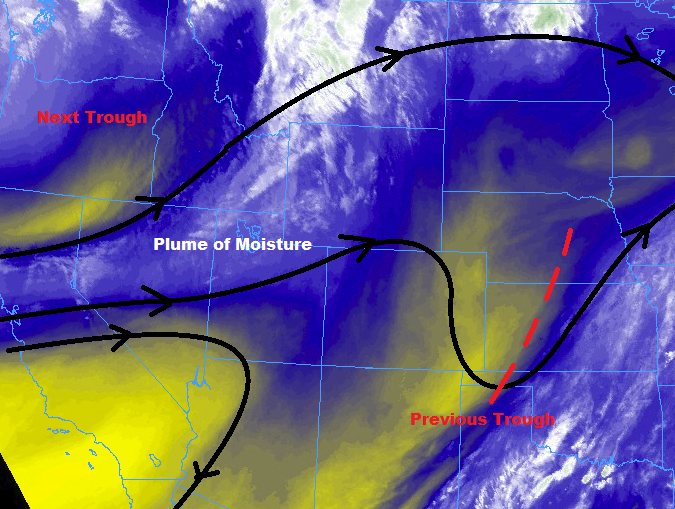
The upper-level trough that had been meandering across the region the past couple of days has finally moved on, shifting over the central Great Plains. Behind the recent upper-level trough, and ahead of the next trough, a plume of moisture has begun to push into western Colorado, which will spread east through the day. This next wave of moisture will provide enough fuel for a few isolated-to-widely scattered showers/thunderstorms over the High Country, and a couple isolated showers/storms over adjacent lower elevations.
The best coverage, relatively speaking, will be north of I-70, where the influence of a passing disturbance will provide some support. Overall, there is no threat of flash flooding as the best moisture is confined to the mid-levels (with drier air near the surface) and there will be very little instability with which to work. Thus, gusty winds and light rain will be the main impacts. For more information on rain rates and timing, please see the zone-specific forecast discussions below.
Today’s Flood Threat Map
For more information on today’s flood threat, see the map below (hover over threat areas for more details). For Zone-Specific forecasts, jump below the map.


Zone-Specific Forecasts
Urban Corridor, Palmer Ridge, Northeast Plains, Southeast Plains, and Raton Ridge:
Plenty of sunshine and warmer temperatures are the main weather story for today, providing a nice kickoff to the weekend. During the afternoon/evening hours, a few clouds will bubble, especially over areas near the mountains. A couple of showers, and perhaps a thunderstorm or two will dot the area, mainly north of I-70 thanks to the presence of the passing disturbance. Gusty winds and light rainfall will be the main impacts from any activity, so no flood threat is the call today. Rainfall rates will generally be less than 0.15 inches/hour, with maximum rates of 0.2-0.4 inches/hour.
Timing: 3 PM – 11 PM, with an isolated shower/thunderstorm or two lingering into the early morning hours over the Northeast Plains in association with the passing disturbance.
Front Range, Northern Mountains, Northwest Slope, Central Mountains, Southeast Mountains, Grand Valley, San Juan Mountains, Southwest Slope, and San Luis Valley:
The day will begin with plenty of sunshine, with clouds increasing over the higher terrain during the afternoon and evening hours in response to the increase in mid-level moisture. A few isolated-to-scattered showers will dot the region, with the best coverage, relatively speaking, over the higher terrain of the Northwest Slope, Northern Mountains, Front Range, and Central Mountains. Rain rates will generally be less than 0.1 inches/hour, with maximum rates of 0.2-0.3 inches/hour.
Timing: 2 PM – 10 PM for areas south of I-70, 1 PM – 1 AM for areas along and north of I-70. A few lingering showers will continue into the early morning hours over the higher terrain of the Northern Mountains, Northwest Slope, Grand Valley, and Central Mountains.