FTB 05-07-2019: Showers and Thunderstorms Continue this Afternoon with a Low Flood Threat Issued for the Urban Corridor

Issue Date: Tuesday, May 7th, 2019
Issue Time: 10:00AM MDT

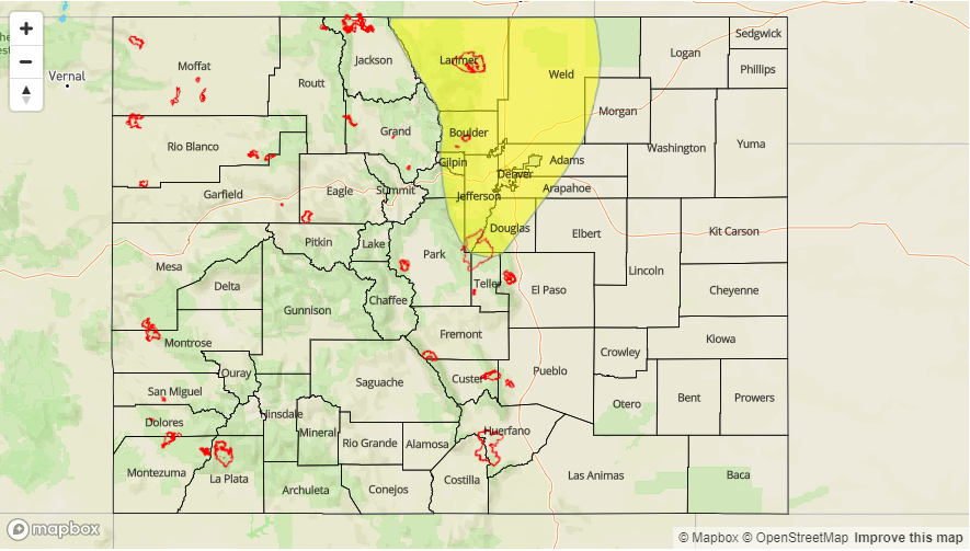
— A LOW flood threat has been issued for portions of the Urban Corridor, Front Range and Northeast Plains

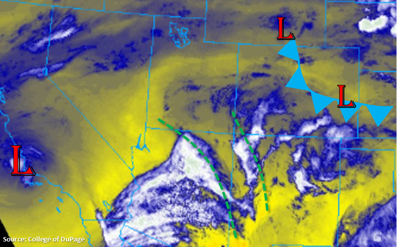
The low coming from southern CA has moved eastward and is currently over Arizona as seen in the water vapor imagery below. Throughout the day, expect the low to keep progressing eastward. This should bring continued favorable dynamics to the state for rainfall and thunderstorms in the mid and upper levels of the atmosphere. Earlier this morning, PW values at DIA were measured at 0.74 inches (which matches the record for this date, but is far from the May record of 1.14 inches). In comparison, the PW value over Grand Junction was at 0.3 inches; however there is some better moisture in the higher terrains near the Divide. Visible satellite shows heavy cloud cover and dense fog over the eastern portion of the state with cloud cover over the Central and Northern Mountains in western Colorado.

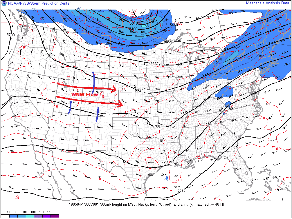
Expecting storm coverage to pick up early this afternoon over the higher terrains with the approaching trough. Storms will be most abundant near the Continental Divide over the northern portions of the high terrains (Central Mountains, Northern Mountains and northern Front Range). Over the Urban Corridor, a bit of instability is possible if low level clouds are able to clear. If this occurs, some thunderstorms with small hail are possible this afternoon/early evening as storms move off of the mountains. A quick 0.5 inches of rain is possible, and combined with small hail, this may cause some urban flooding issues. A Low flood threat has been issued for this reason. Storm movement to the NW at 15 to 20 knots shouldn’t cause many issues over the plains, though some field ponding is possible if multiple storms track over the same area. A cold front will drop through the state overnight, so expecting some light showers overnight.

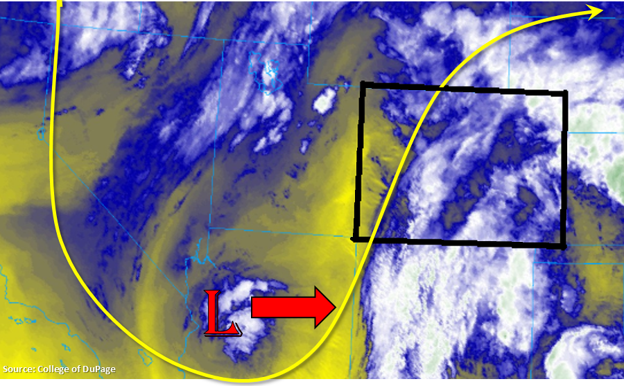
A secondary set of storms forms as a wave passes through the southeast corner of the state. Expecting storms to fire over the Southeast Mountains and Raton Ridge this afternoon. Storm movement this afternoon will be NW at 15 to 20 knots, so not expecting major flooding issues over southeast Colorado. With more instability able to build over the plains, and upper level dynamics combining with low level moisture, another round of severe thunderstorms are likely. Hail up to 1.25 inches is possible along with gusts in the 60mph range for the stronger thunderstorms. Storms and rainfall will likely continue into the night as the upper level jet moves over the eastern plains, so there will be some decent accumulation by morning. As the cold front drops south overnight, there also may be an increase in light shower activity over the Southeast Mountains with the upslope flow.

Today’s Flood Threat Map

For more information on today’s flood threat, see the map below. For Zone-Specific forecasts, scroll below the map.

Flood Threat Legend


Zone-Specific Forecasts:

Front Range, Urban Corridor, Northeast Plains:

Expecting shower coverage to pick up this afternoon as the trough approaches from the west. Low level moisture, mid and upper level dynamics and a bit of clearing over the Urban Corridor may cause some thunderstorm activity this afternoon/early evening. A quick 0.5 inches of rain is possible, and paired with small hail, this may cause drainage issues. Threats for these storms include flooding and field ponding in poorly drained areas. 2-hr totals up to 1 inch may be possible with 1-hr rain rates up to 0.8 inches. Over the higher terrains, max 1-hr rain rates up to 0.6 inches are possible. Expecting some light showers to linger into tomorrow morning as a cold front drops through the state overnight. Temperatures should also begin to drop off today and tonight, which in turn will drop the snow level for tomorrow. A Low flood threat has been issued with a focus on the Urban Corridor.

Primetime: 2PM to 10PM

Southeast Mountains, Palmer Ridge, Raton Ridge, Southeast Plains:

Fog and low level clouds are being reported once again this morning with more dense fog near the mountains. Clearing is expected throughout the morning and with a shortwave moving across the southeast corner of the state this afternoon, storm coverage is also expected to pick up. Showers over the Southeast Mountains and Raton Ridge area are expected to begin by early afternoon. As these storms move into the eastern plains, they will encounter more favorable dynamics. That means another round of severe thunderstorms is possible over the far eastern plains. Max 1-hr rain rates up to 0.8 inches are possible with hail up to 1.25 inches and gusts around 60mph. With decent storm movement, flooding is not expected, although 24-hr totals up to 1 inch are possible as storms linger into the night with the passing cold front and support from the upper level jet. Some light showers are also possible along the Southeast Mountains overnight.

Primetime: 1PM to 5AM

Northwest Slope, Grand Valley, Southwest Slope, Northern Mountains, San Luis Valley, San Juan Mountains, Central Mountains:

Not quite as much moisture over the western portion of the lower elevations with a slot dry air (yellow) seen in the water vapor imagery. Some higher moisture still remains near the Continental Divide, which should allow for some midday precipitation with the approaching wave. Coverage should pick up over the Northern and Central Mountains by noon. With NW movement of the storms, not expecting much rainfall after sundown. Max 1-hr rain rates up to 0.2 inches are possible. A second set of storms moves into western Colorado by early tomorrow morning. With the cold front passing through, low level moisture return is expected, so light showers (and snow above 8-9K ft) are possible by tomorrow morning.

Primetime: 1PM to 8PM

FTB 05-06-2019: Trough Approaches from the West and Widespread Showers return to the Forecast

Issue Date: Monday, May 6th, 2019
Issue Time: 8:40AM MDT

— Flooding is NOT expected today

Today the aforementioned low pressure system starts to move east over southern California. This will cause westerly flow aloft to become more southwesterly throughout the day as the front edge of the trough moves over the state. Currently, upward motion on the front side of the trough can be seen in the water vapor imagery below marked by the green dashed lines. This mid and upper level energy, along with the plume of moisture, will help spark scattered showers and thunderstorms over the higher terrains starting early this afternoon. Over western Colorado, storm movement will be from the southwest to northeast, with the highest accumulations forecast over the Northern Mountains where there is a bit more low-level moisture (dew points in the 30°Fs). A storm or two may also track over the lower elevations of the Northwest Slope. Further south, expect cloudiness with some brief winds and virga.

To the east, a cold front has started dropping through the plains and Urban Corridor. Behind the front, moisture values have increased and dew points are in the upper 40°Fs. This has produced some fog and light rainfall over the northeast corner of the state with cloud cover elsewhere. The front is expected to stall over the Southeast Plains this afternoon, which will could help produce an isolated severe thunderstorm or two over the Southeast Plains along the Colorado and Kansas border. If these storms are able to form (dependent on the low pressure location) threats include hail up to 1 inches and gusts greater than 60 mph. Guidance this morning suggests the bulk of the activity (higher rain rates and more intense storms) will be located over the panhandle of Oklahoma and southern Kansas.

Over the western high terrains, showers and perhaps an isolated thunderstorm or two, will favor the Front Range due to upslope flow and the upper level wave activity coinciding this afternoon. As storms move into the adjacent plains, expected widespread shower activity thanks to the low level moisture return behind the front and easterly low level flow. Highest accumulations will likely be east of I-25 over the Palmer Divide and north of Denver in Weld County. Some showers may linger or reform overnight along the Front Range and Southeast Mountains due to continued upslope flow and shortwave activity with the approaching trough. Despite the widespread rainfall expected this afternoon, flooding is not expected today.

Today’s Flood Threat Map

For more information on today’s flood threat, see the map below. For Zone-Specific forecasts, scroll below the map.

Zone-Specific Forecasts:

Northwest Slope, Grand Valley, Southwest Slope, Northern Mountains, San Luis Valley, San Juan Mountains, Central Mountains:

Southwest to northeast movement of widespread showers over the higher terrains this afternoon will favor southwest and south facing slopes for the highest precipitation accumulations. Rainfall activity is expected to be greatest over the northern Central and Northern Mountains with more isolated activity over the Northwest Slope. Not much accumulation is forecast over the southern regions, but virga and some brief gusty winds are possible. Max 24-hr totals up to 0.35 inches (Northern Mountains/Northwest Slope) and 0.10 inches (northern Central Mountains) are possible. Flooding is not anticipated today.

Primetime: 2PM to 10PM

Front Range, Urban Corridor, Southeast Mountains, Raton Ridge:

A bit of cloud cover over the northern portions of these regions with moisture return behind the cold front. This should start to break up by late morning and allow for more scattered skies this afternoon. Easterly flow at the surface is expected to pair with mid and upper level energy this afternoon to help produce widespread showers. Max 1-hr rain rates up to 0.25 inches are possible. Continued upslope flow overnight may produce continued showers over the higher terrains. Isolated totals by morning of 0.5 inches are possible over the Larimer and Boulder Counties. Flooding is not expected.

Primetime: 1PM to 5AM

Palmer Ridge, Northeast Plains, Southeast Plains:

Fog and low level clouds are being reported behind the front with more dense fog over the Northeast Plains. This means there has been enough moisture return behind the front for more widespread rainfall and thunderstorm activity. A stalled front over the Southeast Plains may allow for an isolated severe thunderstorm or two this evening as storms make their way west from the mountains. Max 1-hr rain rates around 0.5 inches are possible. Over the Palmer Ridge and Northeast Plains, shower activity should be more widespread. Showers are expected to continue overnight with convergence along a boundary over the Northeast Plains. After a couple rounds of rainfall this afternoon and overnight, totals just under 0.5 inches are possible by tomorrow morning.

Primetime: 2PM to 7AM


FTB 05-05-2019: Warmer Again, Isolated-to-Scattered Showers/Storms Expected

Issue Date: 5/5/2019
Issue Time: 8:40 AM

NO FLOOD THREAT IS FORECAST TODAY.

A pleasant start to the day is underway across Colorado, aside from a few clouds over the higher terrain and a mountain wave cloud over the northern Urban Corridor (shown in image below), sunny skies have greeted most of the state. This is in response to high pressure aloft building over the region, and this will allow temperatures to climb a few degrees higher than yesterday’s readings. The abundant sunshine will have its side effects, though, as the high pressure aloft will not be strong enough to suppress a bit of shower/thunderstorm development driven by a combination of daytime heating and a weak disturbance aloft.

With low-level moisture lacking, any shower/thunderstorm development will be high-based, resulting in little precipitation reaching the surface, with the main impact being gusty winds. Over the higher terrain, shower/storm coverage will be scattered, with more isolated activity east of the mountains. There is an opportunity for one or two storms over the far Southeast Plains to tap into some better instability and produce hail up to 1 inch in diameter and gusty winds to 60 mph. For more details on timing, please see the zone-specific discussions below.

Today’s Flood Threat Map

For more information on today’s flood threat, see the map below. For Zone-Specific forecasts, jump below the map.

Zone-Specific Forecasts

Urban Corridor, Northeast Plains, Southeast Plains, Palmer Ridge, and Raton Ridge:

Mostly sunny and a few degrees warmer than yesterday will be the main weather story today. A few isolated, high-based showers/thunderstorms are possible, with the best coverage expected near the interface with the high country. This activity will produce little-to-no precipitation at the surface but will bring gusty winds and plenty of virga. Over the far Southeast Plains, an isolated thunderstorm or two will rumble, producing brief periods of light-to-moderate rainfall, hail up to 0.5-1.0 inches in diameter, and strong winds to 60 mph. The probability of occurrence is 20%, with the better chances existing just across the state line in Kansas, Oklahoma, and Texas.

Maximum rain rates will be less than 0.1 inches for all generic activity, with rain rates from any stronger storms over the Southeast Plains at 0.2-0.5 inches/hour.

Timing: 2 PM – 10 PM

Front Range, Northern Mountains, Northwest Slope, Southeast Mountains, San Luis Valley, Central Mountains, San Juan Mountains, Grand Valley, and Southwest Slope:

Scattered, high-based showers/thunderstorms will kick off over the higher terrain just after lunchtime as daytime heating works in concert with a weak disturbance passing overhead. With low-level moisture lacking, the main impacts will be gusty winds, occasional lightning from weak thunderstorms, and perhaps a brief period of precipitation, mainly over the higher elevations. Activity will diminish quickly after sunset. Maximum rain rates will be less than 0.2 inches/hour for all regions.

Timing: 1 PM – 9 PM

FTB 05-04-2019: Warmer and Mainly Dry, a Few Showers/Thunderstorms

Issue Date: 5/4/2018
Issue Time: 8:40 AM

NO FLOOD THREAT IS FORECAST TODAY.

Surface high pressure has built across much of the state underneath west-northwesterly flow aloft (shown in the image below). This will result in a fairly dry day overall, as below average low-level moisture continues to be ushered in from the west. A ribbon of moisture embedded in the mid-level flow will bring an increase in clouds this afternoon over and near the higher terrain, including the Urban Corridor, with a few high-based, weak showers/thunderstorms developing this afternoon and evening. Little-to-no rainfall is expected from this activity; virga, gusty winds, and occasional lightning will be the main impacts.

Over the eastern plains, a surface trough will develop as the day progresses owing to the west-northwesterly flow aloft. This trough will act as a convergence zone, with westerly surface flow to the west, and easterly surface flow to the east. This trough will set up roughly oriented along a line from Peetz to Akron to Arriba to Las Animas to Kim. A few weak disturbances rippling through the otherwise nondescript flow aloft (blue lines in image) will be the “trigger” mechanism for the development of few scattered thunderstorms east of the line. Due to marginally favorable wind shear enhanced by the surface trough, as well as the increased low-level moisture brought in by the easterly surface flow, a few of the storms will be strong-to-severe, with brief periods of moderate rainfall attending the threat for 0.5-1.5” hail and strong winds. No flood threat is expected from this activity, but isolated ponding issues may arise in poorly drained locations.

Today’s Flood Threat Map

For more information on today’s flood threat, see the map below. For Zone-Specific forecasts, jump below the map.

Zone-Specific Forecasts

Urban Corridor, Northeast Plains, Southeast Plains, Palmer Ridge, and Raton Ridge:

Mostly sunny and dry for most areas, with high temperatures a few degrees warmer than yesterday. A few high-based weak showers/storms will move off of the higher terrain and over adjacent lower elevations between 1 PM and 8 PM, but little-to-no rainfall is expected from this activity; gusty winds and virga will be the main results.

Further to the east, east of the aforementioned line from Peetz to Akron to Arriba to Las Animas to Kim, a few scattered strong-to-severe thunderstorms will rumble this afternoon and evening, kicking off around 2 PM, moving eastward, and ending/exiting the state by 9 PM. Brief periods of moderate rainfall, hail up to 1.5 inches, and strong winds up to 65 mph are possible with these storms.

Front Range, Northern Mountains, Northwest Slope, Southeast Mountains, San Luis Valley, Central Mountains, San Juan Mountains, Grand Valley, and Southwest Slope:

Mostly sunny and dry conditions will be the name of the game for most, with only a few high-based weak showers/thunderstorms over the higher terrain breaking up the otherwise pleasant day. A few sprinkles, and flurries above 12,000 feet, will be possible, but gusty winds and virga will be the main results.

Timing: 1 PM – 9 PM