Issue Date: 5/4/2018
Issue Time: 8:40 AM
NO FLOOD THREAT IS FORECAST TODAY.
Surface high pressure has built across much of the state underneath west-northwesterly flow aloft (shown in the image below). This will result in a fairly dry day overall, as below average low-level moisture continues to be ushered in from the west. A ribbon of moisture embedded in the mid-level flow will bring an increase in clouds this afternoon over and near the higher terrain, including the Urban Corridor, with a few high-based, weak showers/thunderstorms developing this afternoon and evening. Little-to-no rainfall is expected from this activity; virga, gusty winds, and occasional lightning will be the main impacts.
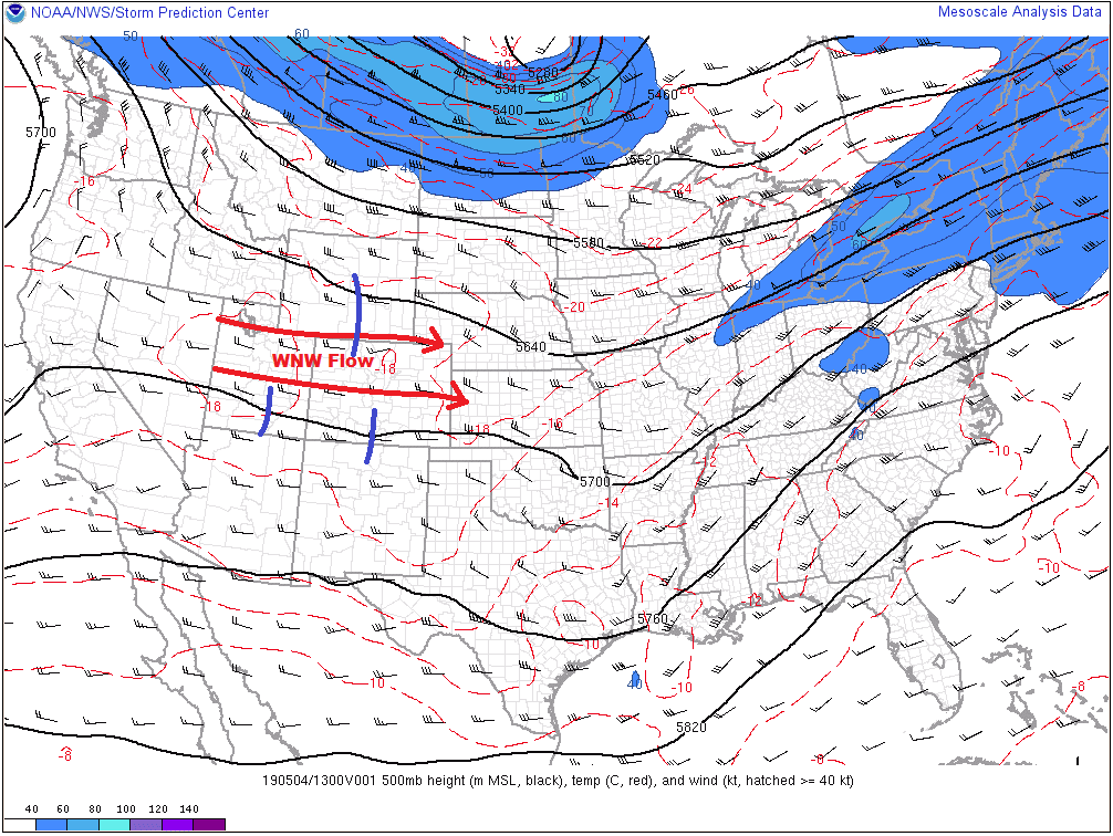
Over the eastern plains, a surface trough will develop as the day progresses owing to the west-northwesterly flow aloft. This trough will act as a convergence zone, with westerly surface flow to the west, and easterly surface flow to the east. This trough will set up roughly oriented along a line from Peetz to Akron to Arriba to Las Animas to Kim. A few weak disturbances rippling through the otherwise nondescript flow aloft (blue lines in image) will be the “trigger” mechanism for the development of few scattered thunderstorms east of the line. Due to marginally favorable wind shear enhanced by the surface trough, as well as the increased low-level moisture brought in by the easterly surface flow, a few of the storms will be strong-to-severe, with brief periods of moderate rainfall attending the threat for 0.5-1.5” hail and strong winds. No flood threat is expected from this activity, but isolated ponding issues may arise in poorly drained locations.
Today’s Flood Threat Map
For more information on today’s flood threat, see the map below. For Zone-Specific forecasts, jump below the map.

Zone-Specific Forecasts
Urban Corridor, Northeast Plains, Southeast Plains, Palmer Ridge, and Raton Ridge:
Mostly sunny and dry for most areas, with high temperatures a few degrees warmer than yesterday. A few high-based weak showers/storms will move off of the higher terrain and over adjacent lower elevations between 1 PM and 8 PM, but little-to-no rainfall is expected from this activity; gusty winds and virga will be the main results.
Further to the east, east of the aforementioned line from Peetz to Akron to Arriba to Las Animas to Kim, a few scattered strong-to-severe thunderstorms will rumble this afternoon and evening, kicking off around 2 PM, moving eastward, and ending/exiting the state by 9 PM. Brief periods of moderate rainfall, hail up to 1.5 inches, and strong winds up to 65 mph are possible with these storms.
Front Range, Northern Mountains, Northwest Slope, Southeast Mountains, San Luis Valley, Central Mountains, San Juan Mountains, Grand Valley, and Southwest Slope:
Mostly sunny and dry conditions will be the name of the game for most, with only a few high-based weak showers/thunderstorms over the higher terrain breaking up the otherwise pleasant day. A few sprinkles, and flurries above 12,000 feet, will be possible, but gusty winds and virga will be the main results.
Timing: 1 PM – 9 PM