Issue Date: Monday, May 6th, 2019
Issue Time: 8:40AM MDT
— Flooding is NOT expected today
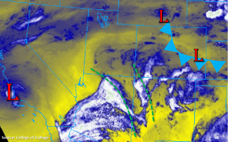
Today the aforementioned low pressure system starts to move east over southern California. This will cause westerly flow aloft to become more southwesterly throughout the day as the front edge of the trough moves over the state. Currently, upward motion on the front side of the trough can be seen in the water vapor imagery below marked by the green dashed lines. This mid and upper level energy, along with the plume of moisture, will help spark scattered showers and thunderstorms over the higher terrains starting early this afternoon. Over western Colorado, storm movement will be from the southwest to northeast, with the highest accumulations forecast over the Northern Mountains where there is a bit more low-level moisture (dew points in the 30°Fs). A storm or two may also track over the lower elevations of the Northwest Slope. Further south, expect cloudiness with some brief winds and virga.
To the east, a cold front has started dropping through the plains and Urban Corridor. Behind the front, moisture values have increased and dew points are in the upper 40°Fs. This has produced some fog and light rainfall over the northeast corner of the state with cloud cover elsewhere. The front is expected to stall over the Southeast Plains this afternoon, which will could help produce an isolated severe thunderstorm or two over the Southeast Plains along the Colorado and Kansas border. If these storms are able to form (dependent on the low pressure location) threats include hail up to 1 inches and gusts greater than 60 mph. Guidance this morning suggests the bulk of the activity (higher rain rates and more intense storms) will be located over the panhandle of Oklahoma and southern Kansas.
Over the western high terrains, showers and perhaps an isolated thunderstorm or two, will favor the Front Range due to upslope flow and the upper level wave activity coinciding this afternoon. As storms move into the adjacent plains, expected widespread shower activity thanks to the low level moisture return behind the front and easterly low level flow. Highest accumulations will likely be east of I-25 over the Palmer Divide and north of Denver in Weld County. Some showers may linger or reform overnight along the Front Range and Southeast Mountains due to continued upslope flow and shortwave activity with the approaching trough. Despite the widespread rainfall expected this afternoon, flooding is not expected today.
Today’s Flood Threat Map
For more information on today’s flood threat, see the map below. For Zone-Specific forecasts, scroll below the map.
Zone-Specific Forecasts:
Northwest Slope, Grand Valley, Southwest Slope, Northern Mountains, San Luis Valley, San Juan Mountains, Central Mountains:
Southwest to northeast movement of widespread showers over the higher terrains this afternoon will favor southwest and south facing slopes for the highest precipitation accumulations. Rainfall activity is expected to be greatest over the northern Central and Northern Mountains with more isolated activity over the Northwest Slope. Not much accumulation is forecast over the southern regions, but virga and some brief gusty winds are possible. Max 24-hr totals up to 0.35 inches (Northern Mountains/Northwest Slope) and 0.10 inches (northern Central Mountains) are possible. Flooding is not anticipated today.
Primetime: 2PM to 10PM
Front Range, Urban Corridor, Southeast Mountains, Raton Ridge:
A bit of cloud cover over the northern portions of these regions with moisture return behind the cold front. This should start to break up by late morning and allow for more scattered skies this afternoon. Easterly flow at the surface is expected to pair with mid and upper level energy this afternoon to help produce widespread showers. Max 1-hr rain rates up to 0.25 inches are possible. Continued upslope flow overnight may produce continued showers over the higher terrains. Isolated totals by morning of 0.5 inches are possible over the Larimer and Boulder Counties. Flooding is not expected.
Primetime: 1PM to 5AM
Palmer Ridge, Northeast Plains, Southeast Plains:
Fog and low level clouds are being reported behind the front with more dense fog over the Northeast Plains. This means there has been enough moisture return behind the front for more widespread rainfall and thunderstorm activity. A stalled front over the Southeast Plains may allow for an isolated severe thunderstorm or two this evening as storms make their way west from the mountains. Max 1-hr rain rates around 0.5 inches are possible. Over the Palmer Ridge and Northeast Plains, shower activity should be more widespread. Showers are expected to continue overnight with convergence along a boundary over the Northeast Plains. After a couple rounds of rainfall this afternoon and overnight, totals just under 0.5 inches are possible by tomorrow morning.
Primetime: 2PM to 7AM