Issue Date: Friday, August 5th, 2022
Issue Time: 10:30AM MDT
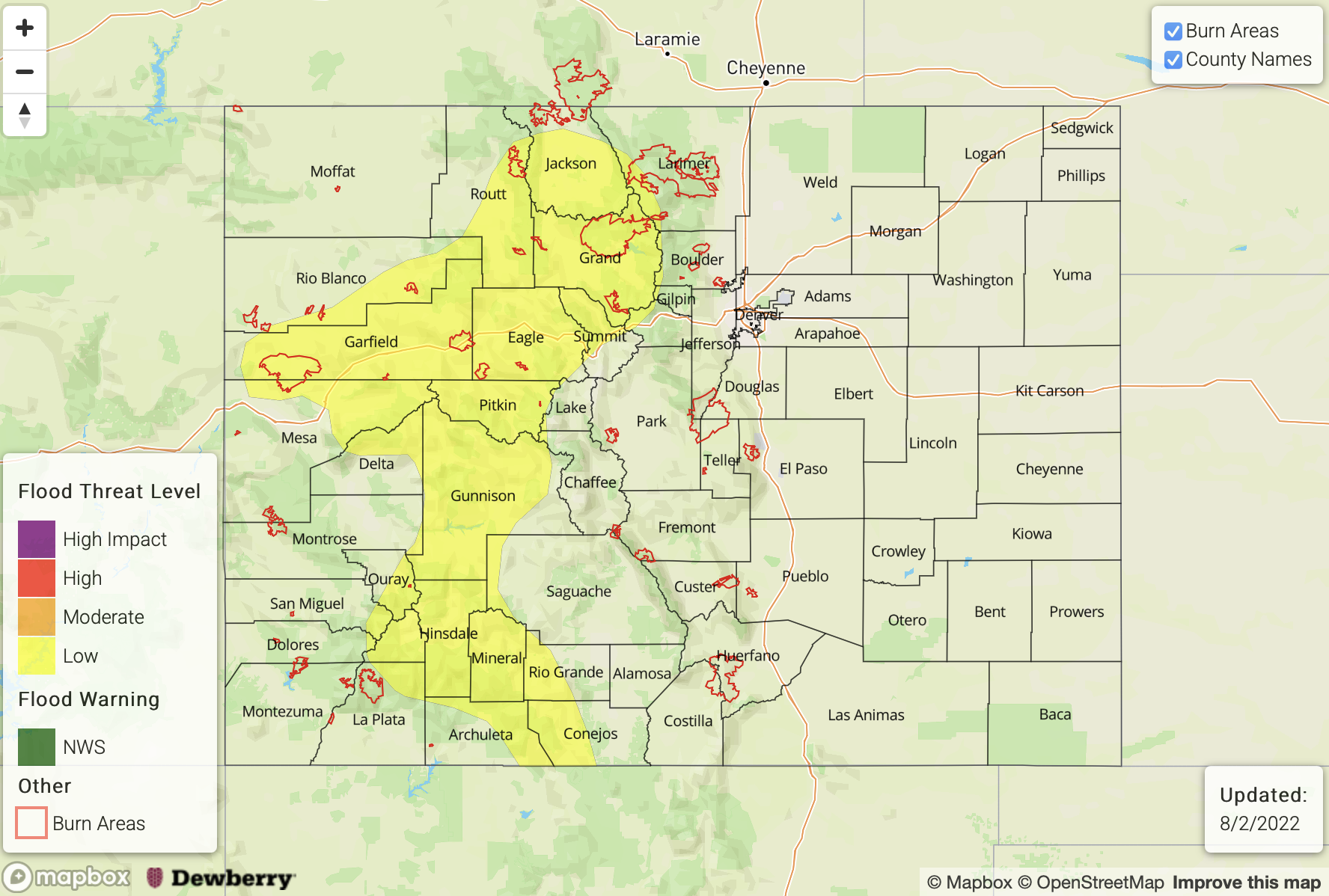
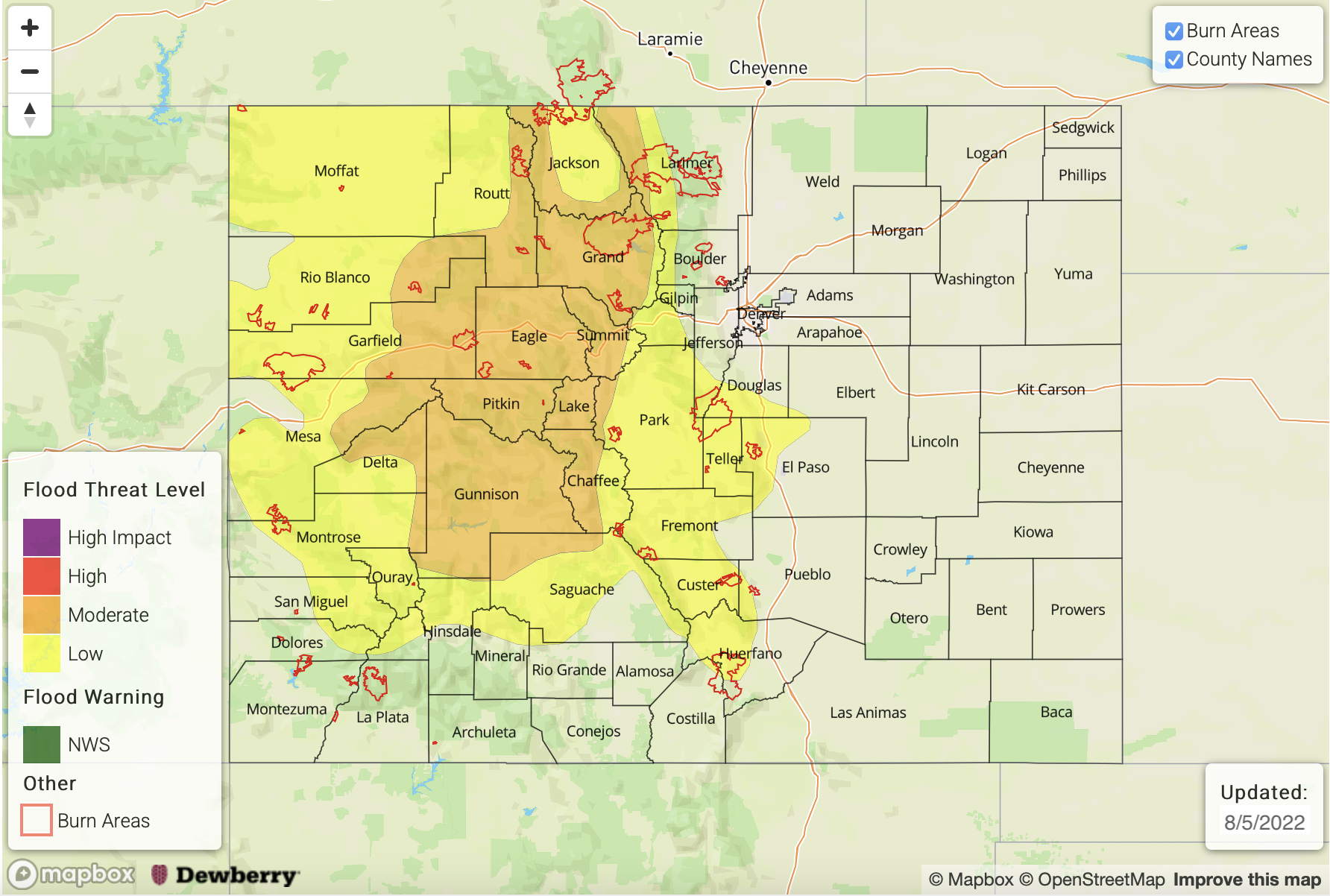
— A MODERATE flood threat has been posted for parts of the Central Mountains and Northern Mountains
— A LOW flood threat has been posted for parts of the Front Range, Palmer Ridge, Southeast Mountains, San Juan Mountains, Grand Valley and Northwest Slope
— Fire-Burn Forecast Summary: 6 burn areas under MODERATE threat; 4 areas under LOW threat; click HERE for more info
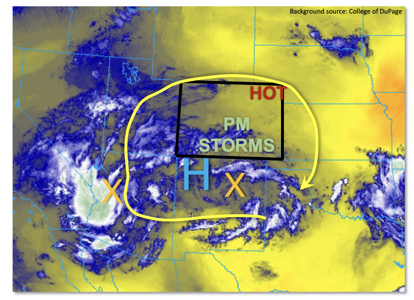
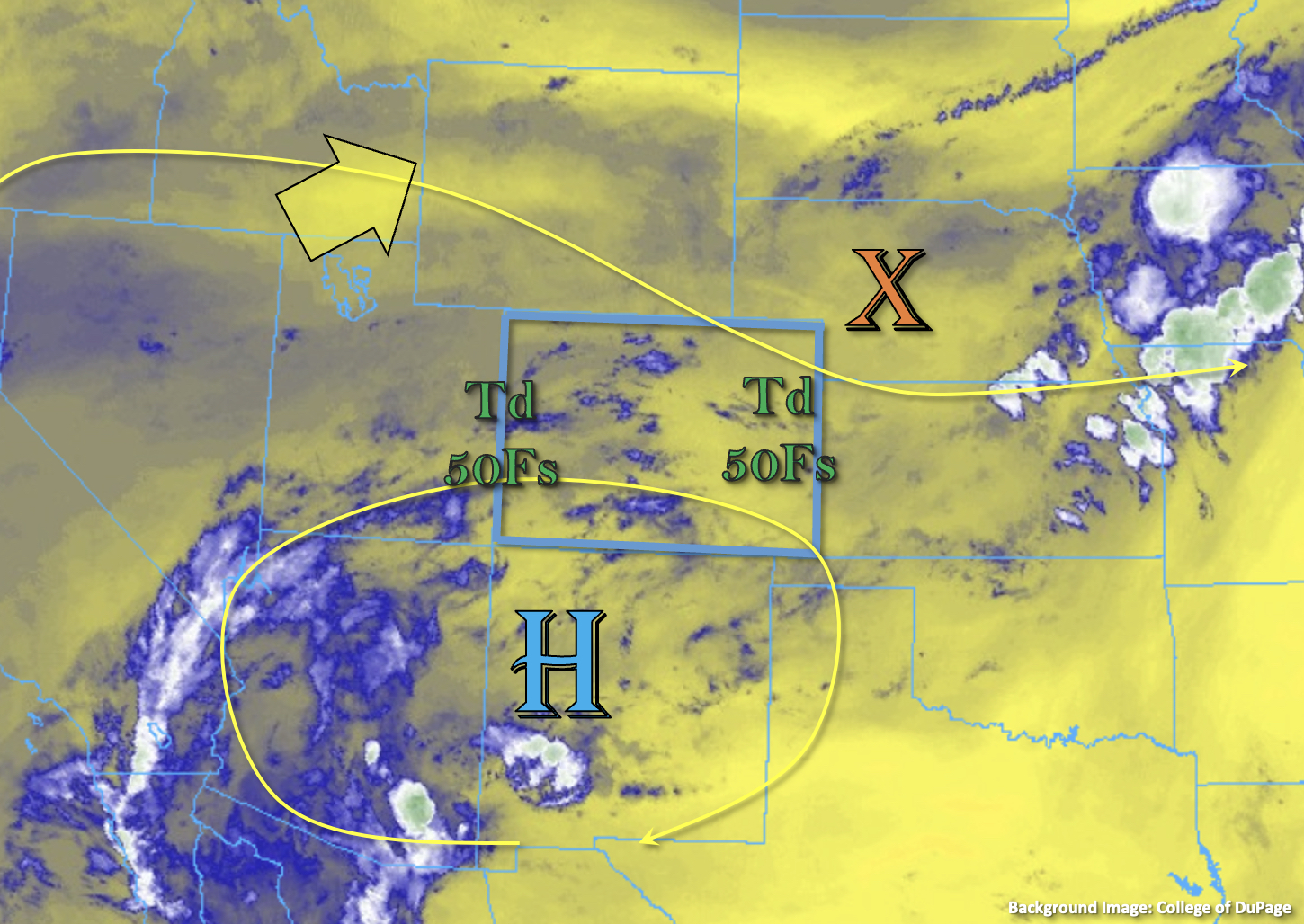
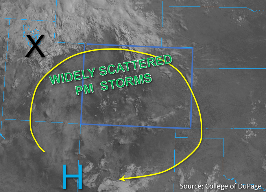
Another active day of heavy rainfall is expected today, as monsoonal moisture has begun to spread north and east across Colorado. As shown the visible satellite image, below, the monsoonal upper-level ridge has shifted southeast of our state. This puts western Colorado in steady, southerly flow, transporting moisture laden air into our higher terrain. PW at Grand Junction jumped ~20% to 1.14 inches, continuing a stretch of well above normal readings. Further east, PW at the Platteville research site came in at 0.94 inches, also notably higher than yesterday. PW is expected to stay steady or increase over central and western Colorado today. With morning sunshine to boost temperatures and create widespread instability, we expect another round of scattered to numerous higher terrain storms. Activity will generally spread north of where it has been over the past 24-48 hours.
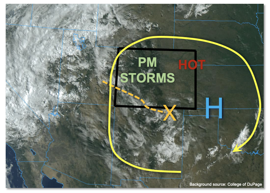
Dynamics-wise, a pronounced disturbance was noted along the NM border this morning (see visible satellite image). This is showing up as a bubble of cooler mid-level air, along with an associate surface circulation, albeit a weak one. This will trek slowly north today, acting as the main focal point for afternoon and evening activity. Meanwhile, very warm mid-level temperatures are again present over eastern Colorado. This will continue to favor subsidence, little to no storm activity and very hot surface temperatures. Daily temperature records could be broken for elevations below 5,500 feet over eastern Colorado, depending on the extent of any afternoon cloud cover.
So, to summarize, we expect scattered to numerous afternoon and evening storms, with the best coverage over the central and northern higher terrain today. With plenty of moisture, adequate instability and slow steering flow, another MODERATE flood threat is warranted today. This is further reinforced by the past few days of activity producing numerous reports of flash flooding, debris slides and mud flows. In short, wet soils are definitely beginning to play a part in enhancing the flood threat. Further east, storms will once again have a hard time forming. However, isolated to perhaps widely scattered activity is possible over the Northeast and Southeast Plains, especially closer to the foothills.
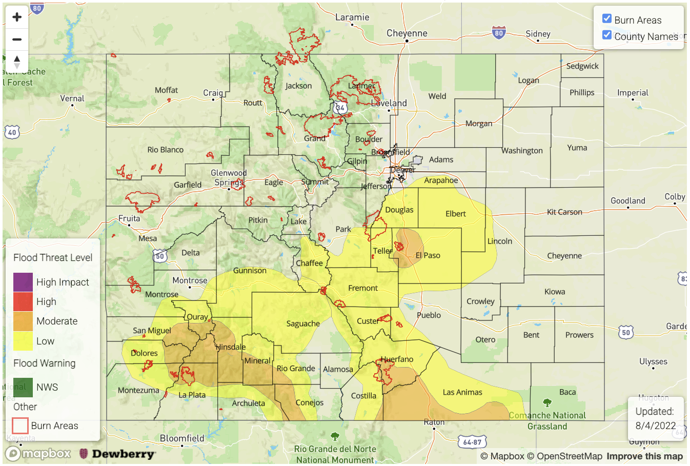
Today’s Flood Threat Map
For more information on today’s flood threat, see the map below. If there is a threat, hover over the threat areas for more details, and click on burn areas to learn more about them. For Zone-Specific forecasts, scroll below the threat map.
Zone-Specific Forecasts:
Northern Mountains, Central Mountains, Front Range, Palmer Ridge, Grand Valley, San Juan Mountains, Southwest Slope, Southeast Mountains, San Luis Valley & Northwest Slope:
Becoming partly to mostly cloudy with scattered to numerous showers and storms developing by mid-afternoon. Highest coverage will be over the northern and central higher terrain, above 7,500 feet. Max 30-min rain rates up to 1.4 inches and max 1-hour rain rates up to 2.0 inches will be possible, warranting a MODERATE flood threat for the central and northern higher terrain and a LOW flood threat for surrounding regions. For lower elevations, rainfall will be more spotty and lighter, along with a chance of gusty winds with the stronger storms.
Primetime: 1PM through 11PM
Northeast Plains, Southeast Plains, Urban Corridor & Raton Ridge:
Mostly sunny and very hot today with near record heat possible for the lower elevations. Isolated to widely scattered storms are possible today, expecially near the foothills. Max 30-min rain rates up to 0.8 inches (west) and 1.2 inches (east) could cause nuisance ponding of roads and low-lying areas. However, flooding is NOT expected today.
Primetime: 2PM through 11PM