Issue Date: Thursday, August 4th, 2022
Issue Time: 11AM MDT
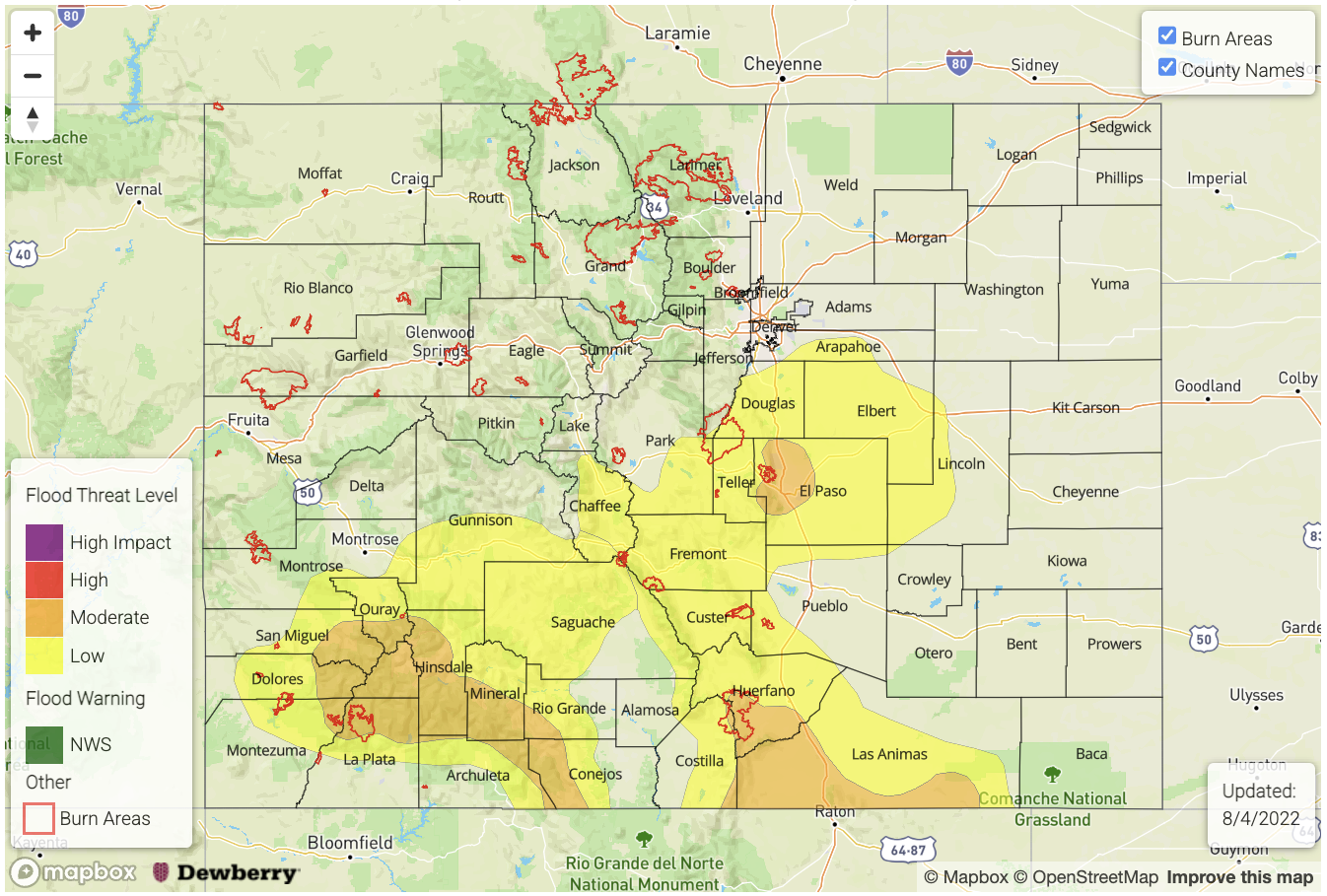
— A MODERATE flood threat has been posted for parts of the Palmer Ridge, Urban Corridor, Southeast Mountains, Raton Ridge and San Juan Mountains
— A LOW flood threat has been posted for parts of the Front Range, Southeast Plains, Central Mountains and Southwest Slope
— Fire-Burn Forecast Summary: 1 burn area under HIGH threat; 1 burn area under MODERATE threat; 3 burn areas under LOW threat; click HERE for more info
Moisture continues to be in abundance over Colorado this morning, as the infamous monsoonal upper-level ridge hangs over our state (see water vapor image below). PW at Grand Junction measured 0.95 inches, down notably since yesterday’s 1.1 inches, but still well above normal. PW at the Platteville research site was 0.75 inches, also down from yesterday’s 0.86. However, a strong moisture gradient was present across southern and eastern Colorado today with PW as high as 1.3 inches along our eastern border and right around 1 inch along our southern border.
Nearly clear skies were observed over most of the state this morning, which will allow for a quick warm-up in temperatures and instability by late morning. A weak surface low pressure was noted over north-central New Mexico. This will likely help focus storm activity over our southern higher terrain today, which will be the prime area for heavy rainfall potential. With pockets of instability exceeding 1,000 J/kg CAPE by early afternoon, slow moving storms will carry the potential for 30-60 minutes of very heavy rainfall. A MODERATE flood threat has been re-issued for the climatologically favored Southeast Mountains, Raton Ridge and San Juan Mountains today for isolated flash flooding, debris slides and mud flows. Numerous mud flows have been reported over the past few days over the steeper terrain, implying that antecedent wet soils have been taking a toll.
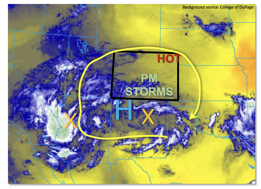
Further north and east, the upper-level ridge is expected to strengthen slightly this afternoon, which will warm mid-level temperatures over northeast Colorado. This subsidence will promote very hot temperatures and be a major obstacle to storm formation. Nonetheless, a steady southerly flow should develop a strong Palmer Ridge meso-low (a.k.a. Denver Convergence Vorticity Zone). This convergence zone will likely fire off at least a few storms from the peak of the Palmer Ridge, possibly stretching northeast all the way to the Nebraska border. Although the threat will be more conditional with mixing out of the boundary layer favoring large dewpoint depressions, any storm that forms will have 2,000+ J/kg of CAPE instability to work with. Thus, a LOW flood threat is warranted for parts of the region, with a narrow MODERATE threat for the climatologically preferred Colorado Springs area.
Today’s Flood Threat Map
For more information on today’s flood threat, see the map below. If there is a threat, hover over the threat areas for more details, and click on burn areas to learn more about them. For Zone-Specific forecasts, scroll below the threat map.
Zone-Specific Forecasts:
Southeast Plains, Urban Corridor, Palmer Ridge, Southeast Mountains & Raton Ridge:
Sunny early then mostly cloudy with scattered to numerous showers and storms developing by early afternoon. Max 30-minute rain rates up to 1.6 inches with max 1-hour rainfall up to 2.6 inches warrants a MODERATE flood threat for the climatologically preferred higher terrain. Isolated flash flooding will be possible, along with the elevated chance of mud flows and debris slides given the antecedent wet soils. A LOW flood threat has been posted for adjoining areas.
Primetime: 12PM to 11PM
Northern Mountains, Central Mountains, Grand Valley, San Juan Mountains, Southwest Slope, San Luis Valley & Northwest Slope:
Mostly sunny early then partly to mostly cloudy with widely scattered (north) to numerous (south) showers and storms expected this afternoon and evening. Max 30-min/60-min rain rates up to 1.0/1.5 inches, respectively, warrant a MODERATE flood threat for southern areas for isolated flash flooding, and more importantly, debris slides and mud flows given wet soils.
Further north, storms will be more spotty with the ability for a quick 0.6 inches in 30 minutes, but flooding is NOT expected north of I-70 (outside burn areas).
Primetime: 12PM through 10PM
Front Range & Northeast Plains:
Mostly sunny early then very hot with isolated to widely scattered storms possible this afternoon. Max 30-minute rain rates up to 0.8 inches possible, but flooding is NOT expected today. Gusty winds could accompany the strongest cells.
Primetime:
2PM through 8PM