Issue Date: Wednesday, August 3rd, 2022
Issue Time: 10:20AM MDT
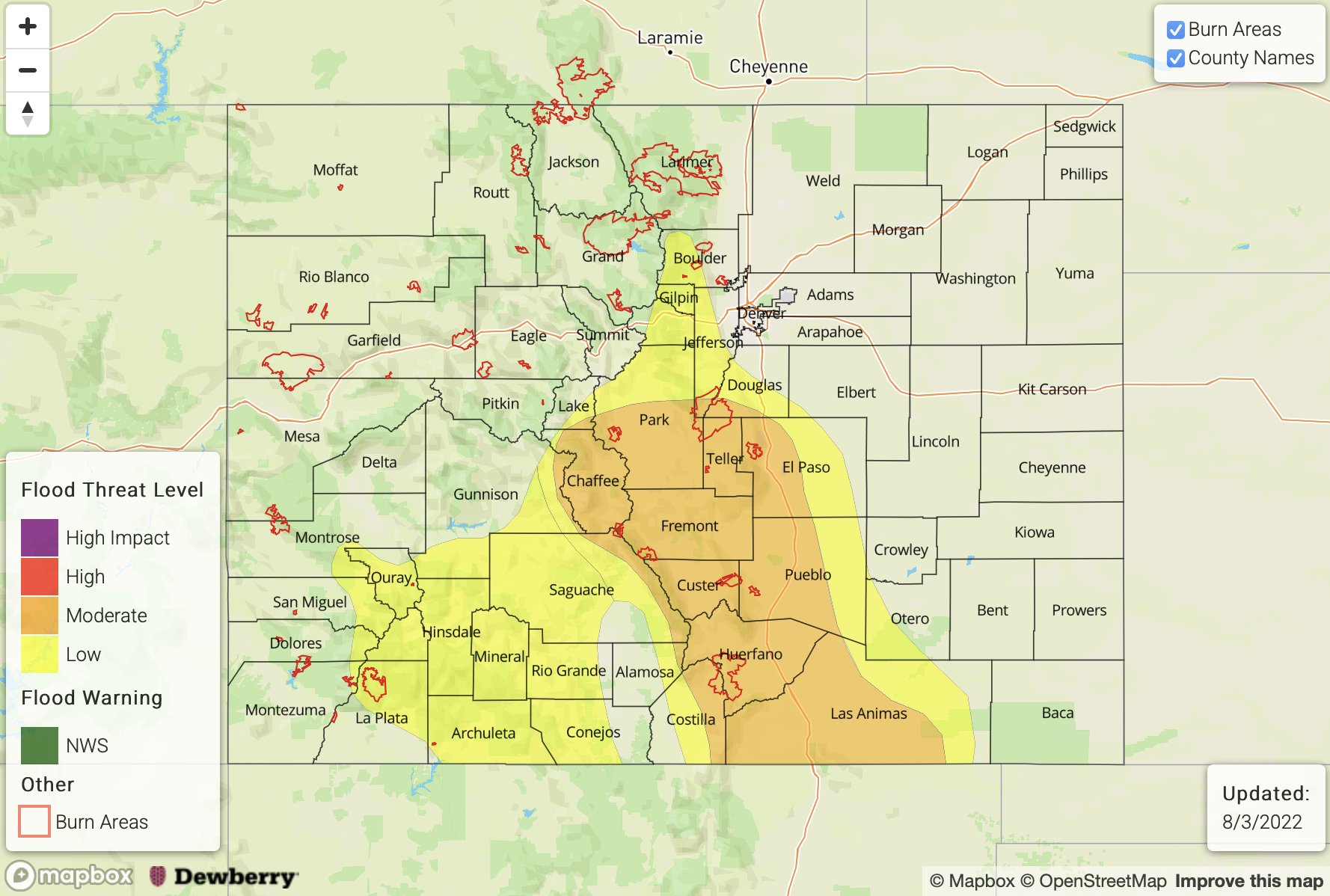
— A MODERATE flood threat has been issued for the Southeast Mountains, Raton Ridge and portions of the Central Mountains, Front Range, Urban Corridor and Southeast Plains
— A LOW flood threat has been issued for the San Juan Mountains and portions of the Southwest Slope and Palmer Ridge
— Fire-Burn Forecast Summary: 1 burn area under HIGH threat, 1 burn area under MODERATE threat; click HERE for more info
Yesterday’s shortwave is now over Nebraska (orange “X”) and behind the trough, northerly surface flow is helping to create some pockets of cooler temperatures over northern Colorado and the I-25 Corridor this morning. Today, over northern Colorado, subsidence behind the trough and building High pressure should help suppress rainfall activity with only isolated storms forecast across the Front Range. Moisture remains quite elevated across the state with dew points over the lower elevations, both east and west, in the 50°Fs. PW at Grand Junction was measured at 1.1 inches and over Platteville, measured at 0.86 inches. With upslope flow developing by early this afternoon, there shouldn’t be a reason for this moisture to mix out. In addition to high moisture, slower steering flows are forecast, which will return the flood threat.
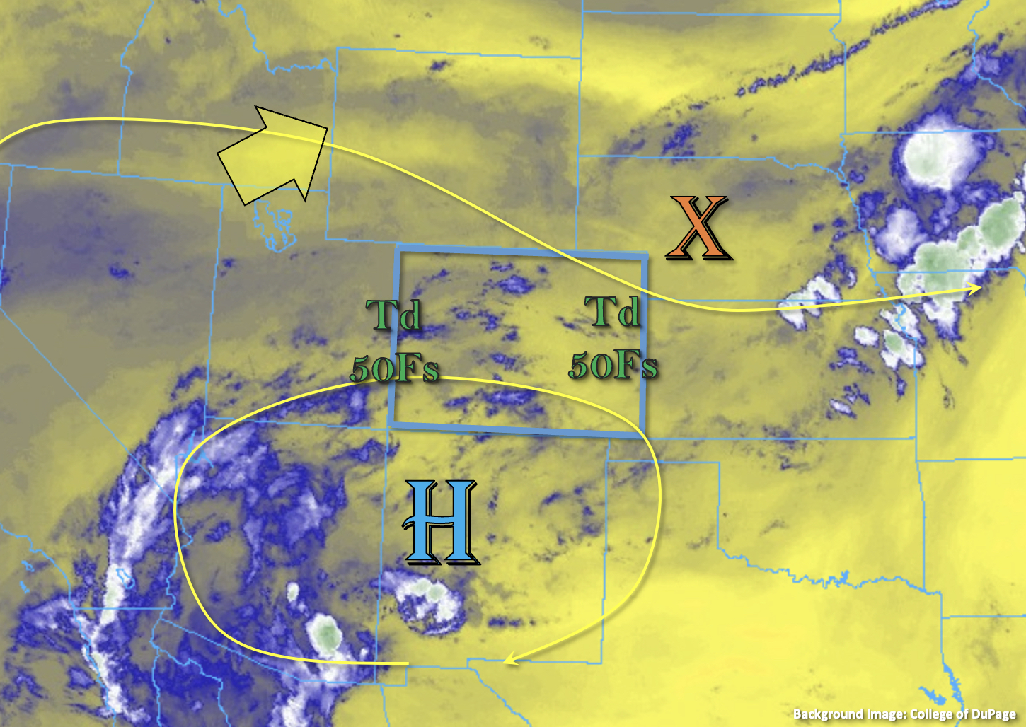
One area of concern for flooding is once again the San Juan Mountains where several days of rainfall have caused soils to become saturated. With another round of afternoon and evening thunderstorms forecast for the area, isolated mud flows, debris slides and road flooding will be possible, so a LOW flood threat has been issued. Over eastern Colorado, if a storm or two is able to overcome subsidence along the Front Range (most likely south), heavy rainfall would be possible, so a LOW flood threat has been issued. Further south, better upslope flow and less subsidence will allow for scattered to numerous thunderstorms to develop by early afternoon over the mountains. For the most part, the storms should stick to the high terrain, but rainfall activity could occur over the immediate adjacent plains with slightly more westerly steering flow and outflow boundaries from the mountain storms possibly initiating additional convection. Due to the high moisture content of the atmosphere and slow steering flows, a MODERATE flood threat has been issued. In addition to heavy rainfall, stronger thunderstorms are likely to produce strong wind gusts and lightning along with small hail.
Today’s Flood Threat Map
For more information on today’s flood threat, see the map below. If there is a threat, hover over the threat areas for more details, and click on burn areas to learn more about them. For Zone-Specific forecasts, scroll below the threat map.
Zone-Specific Forecasts:
Southeast Mountains, Front Range, Central Mountains, Raton Ridge, Urban Corridor, Palmer Ridge, Northeast Plains & Southeast Plains:
Storms should mostly stay over the high terrain today, but some spillover is possible onto the ridges and adjacent plains further south. Max 30-minute rain rates up to 1.5 inches and 1 to 2-hour totals up to 2.5 inches will be possible. A MODERATE flood threat has been issued. Less certainty about isolated storms over the Front Range, but if one or two develop, max 30-minute rain rates up to 0.9 inches and 1-hour totals up to 1.25 inches would be possible. For this area a LOW flood threat has been issued. Threats today include mud flows and debris slides over steeper terrains, road flooding, field ponding and rises in local streams and creeks. Light showers may linger overnight, but most rainfall activity should come to an end by midnight.
Primetime: 1PM to 12AM
San Juan Mountains, Southwest Slope, San Luis Valley, Northwest Slope, Northern Mountains & Grand Valley:
It should stay mostly dry north today with some isolated rainfall activity possible over the high terrain of the Grand Valley and Northwest Slope. Isolated storm totals up to 0.85 inches will be possible, but most storms will produce wind and totals under 0.5 inches. Further south, the saturated soils are likely to take another hit from the scattered storms that develop with residual monsoon moisture. Max 30-minute rain rates up to 1.1 inches and storm totals up to 1.5 inches will be possible. This could cause isolated mud flows and debris slides along with road flooding and rises in local streams and rivers. A LOW flood threat has been issued. The flood threat should end just after sunset, but some lighter showers may linger into tomorrow morning.
Primetime: 12PM to Ongoing