FTB 05-31-2019: Sunny and Warm with Isolated Afternoon Storms Forecast

Issue Date: Friday, May 31st, 2019
Issue Time: 8:15AM MDT

–Flooding is NOT expected today

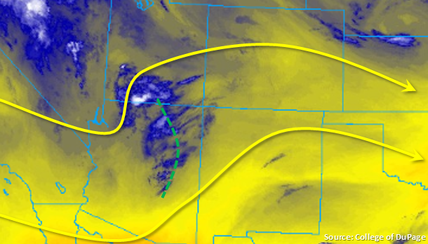
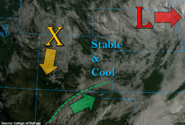
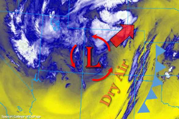
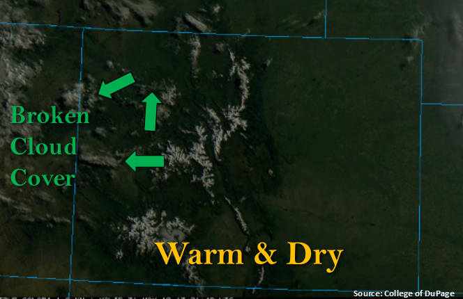
Minus some isolated, broken cloud cover over the Grand Valley and Northwest Slope (green arrows), this morning is off to a clear start. Temperatures are forecast to increase a couple more degrees today, which will feel quite pleasant to round out a chilly May. The ridge builds back to the northwest throughout the day with westerly flow aloft, similar to yesterday. Reduced low-level moisture and downsloping flow over the southern portion of the state should keep this area rain free. So while some afternoon cloud cover is likely over the San Juan, Southeast Mountains and immediate, adjacent Southeast Plains, only expect trace amounts of precipitation at the most. Upslope flow is expected to trigger isolated showers and possibly a weak thunderstorm or two over the Northern Mountains, Front Range and northern Central Mountains this afternoon. A few weak thunderstorms are also possible over the Palmer Ridge with northeast surface flow. Activity will likely spread into the Urban Corridor and Northeast Plains, but high-bases should limit rainfall. A couple weak thunderstorms are possible with lightning and gusty winds being the main threats. Flooding is not forecast.

Today’s Flood Threat Map

For more information on today’s flood threat, see the map below. For Zone-Specific forecasts, scroll below the map.

Zone-Specific Forecasts:

Front Range, Northern Mountains, Central Mountains, Urban Corridor, Palmer Ridge, Raton Ridge:

Isolated rainfall with a couple weak thunderstorms may be possible this afternoon. High-bases will make gusty winds and lightning the main threat. Expect storms in the immediate adjacent plains to produce the most rainfall. Max 1-hr rain rates up to 0.2 inches (east) and 0.25 inches (west) are possible under the strongest storms. Activity is forecast to end shortly after sundown.

Primetime: 1PM to 9PM

Southeast Mountains, San Juan Mountains, Southeast Plains, Northwest Slope, Grand Valley, Southwest Slope, Northeast Plains, San Luis Valley:

High temperatures are still on the up and up, so expected those to increase 5°F or so degrees this afternoon when compared to the same time yesterday. Afternoon cloud cover is likely over the mountains and immediate, adjacent Southeast Plains/Raton Ridge area. Low level moisture will scour out quickly with the westerly flow aloft, so only expecting a couple sprinkles at most from these clouds.


FTB 05-30-2019: Rinse and Repeat Pattern with High Temperatures Beginning to Rebound

Issue Date: Thursday, May 30th, 2019
Issue Time: 8:50AM MDT

–Flooding is NOT expected today

Temperatures begin to rebound today with highs 5-10°F warmer than yesterday. This is still slightly below average, but with the coolness this month, it’s going to feel like summer has arrived. A ridge will begin to build over the state today, which will produce westerly winds aloft. With only residual moisture remaining under the ridge (as seen in the water vapor imagery below), upslope flow will spark only isolated to scattered storms over the mountains this afternoon. Lightning will be the main threat as well as brief, moderate rainfall in isolated incidences. A weak shortwave over Arizona will move west, which may help enhance storm coverage over the southern third of the state. Not expecting much rainfall action over the adjacent plains this afternoon and evening, except over the Palmer and Raton Ridges. Expect most storms to dissipate similar to yesterday as they move east. The passing shortwave may allow a weak thunderstorm or two to survive over the far Southeast Plains along the southern Colorado border. Isolated gusts up to 30 mph may accompany these thunderstorms along with lightning and small hail. Activity is expected to end a couple hours after sundown, and as anticipated, there is no flood threat.

Today’s Flood Threat Map

For more information on today’s flood threat, see the map below. For Zone-Specific forecasts, scroll below the map.

Zone-Specific Forecasts:

Front Range, Northern Mountains, Southeast Mountains, San Juan Mountains, Central Mountains, Urban Corridor, Palmer Ridge, Raton Ridge, Southeast Plains:

Isolated storms expected over the mountains this afternoon with increased coverage over the southern Front Range, Southeast Mountains and San Juans. With a passing shortwave, a weak thunderstorm may be able to survive as it moves off the Raton Ridge into the Southeast Plains along the southern border. With dew points in the low 40°Fs over this area, storms will be high-based, so brief gusty winds (30 mph range) may be possible with lightning, 1 inch hail and only moderate, brief rainfall. Storms that pass directly over the Spring Creek burn area should be monitored closely, but quick storm motion and lack of low-level moisture over this area should keep it threat free. Max 1-hr rain rates up to 0.4 inches (west) and 0.6 inches (east) are possible.

Primetime: 1PM to 10PM

Northwest Slope, Grand Valley, Southwest Slope, Northeast Plains, San Luis Valley:

High temperatures will increase 5-10°F this afternoon. Skies will be mostly clear except when the weak shortwave passes overhead. This will increase cloud cover, but will only provide a little shade from the sun. Light rainfall may be possible over the Southwest Slope over the steeper terrains of San Miguel and Dolores Counties as well as over the Flat Tops. Totals are expected to remain under 0.1 inches.

Primetime: 1PM to 7PM

FTB 05-29-2019: Cool Temperatures Continue with Scattered Storms Forecast for the High Country

Issue Date: Wednesday, May 29th, 2019
Issue Time: 8:30AM MDT

–Flooding is NOT expected today

Busy visible satellite image below to start Wednesday. Over Nebraska, the low pressure system that has affected our weather the last couple of days will begin to move east and break apart. A vorticity max has broken off the back side of the low and is currently over the northwest corner of the state. This will slide south throughout the day and help spark some scattered showers and weak thunderstorms over the mountains this afternoon in tandem with the diurnal flow. Lastly, there is a weaker wave brushing the southern border that is helping produce some early morning cloud cover in the wake of the cold front over the Southeast Mountains and Raton Ridge. Expecting this feature to move to the ENE throughout the day, which should help spark a few weak thunderstorms and rainfall over the Raton Ridge this afternoon. A stable and cool air mass will remain intact over the Eastern Plains, which will reduce high temperatures today. Storms that move into this area are forecast to dissipate quickly, so only trace amounts of accumulation (if any) are forecast for this region.

Diurnal flow, residual moisture and the vorticity max will start to spark scattered rainfall and weak thunderstorms over the mountains beginning later this morning. The snow line should remain above 10,000 feet, so this will not be a major winter weather event. Weak steering winds will allow storms to fester over an area for a couple of hours, so totals up to 1 inch are possible over the Central and southern Front Range Mountains near the Divide. The stratiform rain pushes into the adjacent plains late this afternoon, but outside of the immediate adjacent plains where the Palmer Ridge will help provide a little more convergence, storms are expected to dissipate quickly. Rain accumulations are expected to stay west of I-25. Flooding is not expected.

Today’s Flood Threat Map

For more information on today’s flood threat, see the map below. For Zone-Specific forecasts, scroll below the map.

Zone-Specific Forecasts:

Front Range, Northern Mountains, Southeast Mountains, San Juan Mountains, Central Mountains, Urban Corridor, Palmer Ridge, Raton Ridge:

Scattered storms with gradual accumulating rainfall are expected over the mountains today with the highest accumulations forecast along the Continental Divide where a little more convection is possible. Isolated 24-hour totals over the eastern Central Mountains, southern Front Range may reach 1 inch, but max 1-hr rain rates will stay below 0.35 inches. Over the Southeast and San Juan Mountains, 24-hour totals will be closer to 0.5 inches. Rainfall is forecast to move into the adjacent plains over the Palmer Ridge area (accumulations west of I-25) this afternoon with max 1-hr rain rates of 0.2 inches possible. Further south, the Raton Ridge storms may produce totals up to 0.4 inches closer to the Southeast Mountains. Small hail is possible with the weak thunderstorms this afternoon along with some brief gusty winds, but severe storms are not forecast. Storm will come to an end a couple hours after sundown, and flooding is not forecast.

Primetime: 11AM to 11PM

Northwest Slope, Grand Valley, Southwest Slope, Northeast Plains, Southeast Plains, San Luis Valley:

Cooler temperatures have worked their way into southern Colorado. Expect high temperatures to remain below average throughout the day with highs in 60°Fs. With a stable air mass in place over the eastern plains and western valleys, storms should dissipate as they move into the areas. Thus, accumulation will be zero to trace amounts at most. The best chance for accumulation is over northern portion of the Southwest Slope, but totals will remain under 0.1 inches. Flooding is not expected.

Primetime: 11AM to 8PM

FTB 05-28-2019: Showers and Weak Thunderstorms Forecast for Northeastern Colorado as Upper Low Passes Overhead

Issue Date: Tuesday, May 28th, 2019
Issue Time: 9:20AM MDT

–Flooding is NOT expected today

Cooler temperatures to start the day with the passage of a cold front, which can be seen in the water vapor imagery below. High temperatures are forecast to be 10-15°F cooler than Monday putting us back below average for late May. Dry air has worked its way into the eastern mountains and Front Range for a sunny start today, minus some light convection over the Northeast Plains. Ongoing showers were present in this area overnight thanks to left exit region of the jet associated with the approaching system. This helped produce a strong (and loud) overnight thunderstorm in Denver that produced a lot of nickel to quarter sized hail around 1 AM.

Today, the low will move towards the Nebraska panhandle. Storm motion will be to the northwest on the front side of the low and southeast on the backside of the low. This will keep the majority of the Southeast Mountains, Raton Ridge and southern Southeast Plains dry due to downsloping winds. However, some light accumulation may be possible over the Southeast Mountains at the highest elevations. Forecasting an increase in scattered rainfall and some thunderstorms over the Urban Corridor, Northeast Plains and Palmer Ridge this afternoon. Storms may produce some small hail and gusty winds under the strongest storms. An isolated severe storm cannot be ruled out over the Northeast Plains where temperatures are a little warmer (more instability). Although rain may continue over an area for 2-3 hours, dew points are only in the upper 40°Fs and temperatures will only reach the low 50°Fs. This should limit the amount of instability, so rainfall will be more gradual than convective in nature. Soils may be saturated in some areas from the last couple of days (Weld, Morgan, Adams, Logan), but minus some minor field ponding over these areas, flooding is not anticipated.

Over the Northern Mountains and Front Range, wrap around precipitation will bring snow to elevations above ~8K feet with the snow line dropping a little bit more tonight. Accumulations over the higher elevations will be in the 5 to 10 inch range (Northern Mountains/southern Front Range) and 8 to 16 inch range over the northern Front Range. For western Colorado, expect precipitation to mostly be confined to the higher elevations with some isolated rainfall moving off the higher elevations into the adjacent valleys with the northerly storm motion. Flooding is not expected.

Today’s Flood Threat Map

For more information on today’s flood threat, see the map below. For Zone-Specific forecasts, scroll below the map.


Zone-Specific Forecasts:

Front Range, Northern Mountains, Urban Corridor, Palmer Ridge, Northeast Plains:

Expecting showers to pick up in coverage this afternoon as the low passes through the area. Snow will fall over the northern mountains above ~8K feet with cold rain at the lower elevations in the mountains. The snow line may drop tonight 1,000-1,500 feet after sundown for a couple of hours of snowfall. Rainfall with some embedded convection is likely over the adjacent plains with an isolated severe storm possible over the Northeast Plains where temperatures are a little warmer. Max 2-hr totals up 1.3 inches are possible with widespread 24-hr totals over northern Urban Corridor reaching 1 inch. Small hail and gusty winds are possible as well. To the south, 2-hr totals will drop to around 0.5 inches. Flooding is not forecast, although some minor field ponding is possible over areas with saturated soils. Storms should end west to east this evening beginning around 10PM, and light showers over the Northeast Plains may be possible overnight.

Primetime: 11AM to 2AM

Northwest Slope, Grand Valley, Southwest Slope, San Juan Mountains, Central Mountains:

Cooler temperatures to start the day. Wrap around moisture and diurnal flow will bring some scattered showers to the northern portion of these lower elevation regions this afternoon. Coverage will be much less further south with the expectation of the Central and San Juan Mountains. Max 1-hr rain rates up to 0.3 inches are possible with 24-hour totals up to 0.6 inches.

Primetime: 12PM to 10PM

Raton Ridge, Southeast Plains, Southeast Mountains, San Luis Valley:

Downsloping winds should keep most of these regions rain free today. There will be some light accumulation possible over the highest elevations of the Southeast Mountains. Temperatures will also be a few degrees warmer than over northeast Colorado. Overnight, another cold front will push south, which should drop low temperatures tonight and high temperatures tomorrow. Brief gusty winds may be possible as this pushes south.