Issue Date: Thursday, May 30th, 2019
Issue Time: 8:50AM MDT
–Flooding is NOT expected today
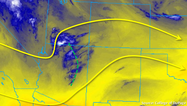
Temperatures begin to rebound today with highs 5-10°F warmer than yesterday. This is still slightly below average, but with the coolness this month, it’s going to feel like summer has arrived. A ridge will begin to build over the state today, which will produce westerly winds aloft. With only residual moisture remaining under the ridge (as seen in the water vapor imagery below), upslope flow will spark only isolated to scattered storms over the mountains this afternoon. Lightning will be the main threat as well as brief, moderate rainfall in isolated incidences. A weak shortwave over Arizona will move west, which may help enhance storm coverage over the southern third of the state. Not expecting much rainfall action over the adjacent plains this afternoon and evening, except over the Palmer and Raton Ridges. Expect most storms to dissipate similar to yesterday as they move east. The passing shortwave may allow a weak thunderstorm or two to survive over the far Southeast Plains along the southern Colorado border. Isolated gusts up to 30 mph may accompany these thunderstorms along with lightning and small hail. Activity is expected to end a couple hours after sundown, and as anticipated, there is no flood threat.
Today’s Flood Threat Map
For more information on today’s flood threat, see the map below. For Zone-Specific forecasts, scroll below the map.
Zone-Specific Forecasts:
Front Range, Northern Mountains, Southeast Mountains, San Juan Mountains, Central Mountains, Urban Corridor, Palmer Ridge, Raton Ridge, Southeast Plains:
Isolated storms expected over the mountains this afternoon with increased coverage over the southern Front Range, Southeast Mountains and San Juans. With a passing shortwave, a weak thunderstorm may be able to survive as it moves off the Raton Ridge into the Southeast Plains along the southern border. With dew points in the low 40°Fs over this area, storms will be high-based, so brief gusty winds (30 mph range) may be possible with lightning, 1 inch hail and only moderate, brief rainfall. Storms that pass directly over the Spring Creek burn area should be monitored closely, but quick storm motion and lack of low-level moisture over this area should keep it threat free. Max 1-hr rain rates up to 0.4 inches (west) and 0.6 inches (east) are possible.
Primetime: 1PM to 10PM
Northwest Slope, Grand Valley, Southwest Slope, Northeast Plains, San Luis Valley:
High temperatures will increase 5-10°F this afternoon. Skies will be mostly clear except when the weak shortwave passes overhead. This will increase cloud cover, but will only provide a little shade from the sun. Light rainfall may be possible over the Southwest Slope over the steeper terrains of San Miguel and Dolores Counties as well as over the Flat Tops. Totals are expected to remain under 0.1 inches.
Primetime: 1PM to 7PM