Issue Date: Tuesday, May 28th, 2019
Issue Time: 9:20AM MDT
–Flooding is NOT expected today
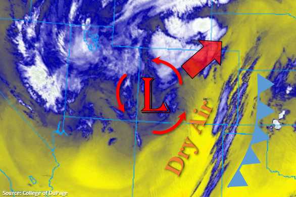
Cooler temperatures to start the day with the passage of a cold front, which can be seen in the water vapor imagery below. High temperatures are forecast to be 10-15°F cooler than Monday putting us back below average for late May. Dry air has worked its way into the eastern mountains and Front Range for a sunny start today, minus some light convection over the Northeast Plains. Ongoing showers were present in this area overnight thanks to left exit region of the jet associated with the approaching system. This helped produce a strong (and loud) overnight thunderstorm in Denver that produced a lot of nickel to quarter sized hail around 1 AM.
Today, the low will move towards the Nebraska panhandle. Storm motion will be to the northwest on the front side of the low and southeast on the backside of the low. This will keep the majority of the Southeast Mountains, Raton Ridge and southern Southeast Plains dry due to downsloping winds. However, some light accumulation may be possible over the Southeast Mountains at the highest elevations. Forecasting an increase in scattered rainfall and some thunderstorms over the Urban Corridor, Northeast Plains and Palmer Ridge this afternoon. Storms may produce some small hail and gusty winds under the strongest storms. An isolated severe storm cannot be ruled out over the Northeast Plains where temperatures are a little warmer (more instability). Although rain may continue over an area for 2-3 hours, dew points are only in the upper 40°Fs and temperatures will only reach the low 50°Fs. This should limit the amount of instability, so rainfall will be more gradual than convective in nature. Soils may be saturated in some areas from the last couple of days (Weld, Morgan, Adams, Logan), but minus some minor field ponding over these areas, flooding is not anticipated.
Over the Northern Mountains and Front Range, wrap around precipitation will bring snow to elevations above ~8K feet with the snow line dropping a little bit more tonight. Accumulations over the higher elevations will be in the 5 to 10 inch range (Northern Mountains/southern Front Range) and 8 to 16 inch range over the northern Front Range. For western Colorado, expect precipitation to mostly be confined to the higher elevations with some isolated rainfall moving off the higher elevations into the adjacent valleys with the northerly storm motion. Flooding is not expected.
Today’s Flood Threat Map
For more information on today’s flood threat, see the map below. For Zone-Specific forecasts, scroll below the map.
Zone-Specific Forecasts:
Front Range, Northern Mountains, Urban Corridor, Palmer Ridge, Northeast Plains:
Expecting showers to pick up in coverage this afternoon as the low passes through the area. Snow will fall over the northern mountains above ~8K feet with cold rain at the lower elevations in the mountains. The snow line may drop tonight 1,000-1,500 feet after sundown for a couple of hours of snowfall. Rainfall with some embedded convection is likely over the adjacent plains with an isolated severe storm possible over the Northeast Plains where temperatures are a little warmer. Max 2-hr totals up 1.3 inches are possible with widespread 24-hr totals over northern Urban Corridor reaching 1 inch. Small hail and gusty winds are possible as well. To the south, 2-hr totals will drop to around 0.5 inches. Flooding is not forecast, although some minor field ponding is possible over areas with saturated soils. Storms should end west to east this evening beginning around 10PM, and light showers over the Northeast Plains may be possible overnight.
Primetime: 11AM to 2AM
Northwest Slope, Grand Valley, Southwest Slope, San Juan Mountains, Central Mountains:
Cooler temperatures to start the day. Wrap around moisture and diurnal flow will bring some scattered showers to the northern portion of these lower elevation regions this afternoon. Coverage will be much less further south with the expectation of the Central and San Juan Mountains. Max 1-hr rain rates up to 0.3 inches are possible with 24-hour totals up to 0.6 inches.
Primetime: 12PM to 10PM
Raton Ridge, Southeast Plains, Southeast Mountains, San Luis Valley:
Downsloping winds should keep most of these regions rain free today. There will be some light accumulation possible over the highest elevations of the Southeast Mountains. Temperatures will also be a few degrees warmer than over northeast Colorado. Overnight, another cold front will push south, which should drop low temperatures tonight and high temperatures tomorrow. Brief gusty winds may be possible as this pushes south.