Issue Date: Saturday, June 8th, 2019
Issue Time: 9:10AM MDT
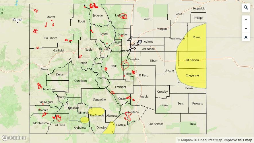
–A LOW flood threat has been issued for potions of the Northeast Plains, Palmer Ridge and Southeast Plains.
–A LOW flood threat has been issued for portions of the San Antonio and Conejos Rivers, Rio Grande River near Del Norte and in southern Mineral County along highway 160 between mile markers 160 and 161 near Wolf Creek Pass.
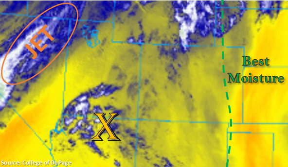
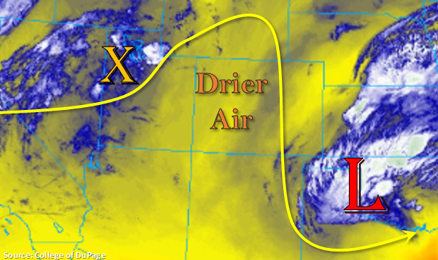
The cold front from the approaching trough has moved into the northwest corner of the state. Temperatures this morning are in the 40°Fs over this area and then rise to 60°Fs over the Grand Valley (further south), which shows you the strength of the front. Today, the front will begin to drop south with a second, more powerful surge occurring overnight. Expect temperatures tomorrow morning statewide, to be similar to what is currently occurring over the Northwest Slope. Western Colorado will be lacking low level moisture once again today, so the best chance for trace amounts of accumulation will be over the Northern Mountains with clear conditions to the south.
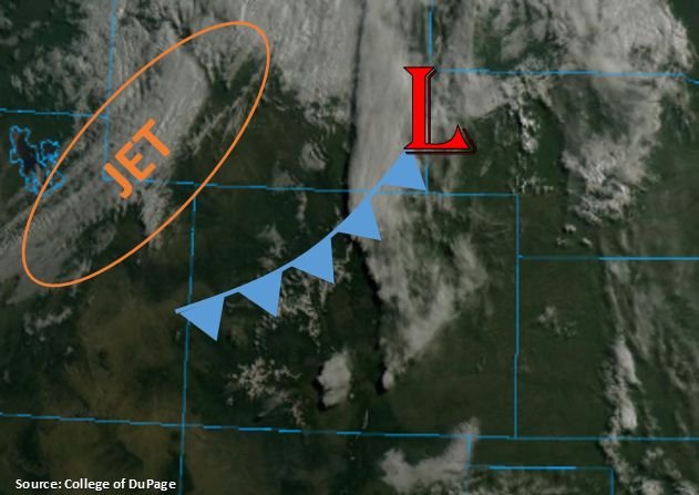
This afternoon, expect storms to fire over the eastern mountains once again. With the first front semi-stalling over the northeast corner of the state, more low level moisture will be available over this area. Thus, storms are expected to have the most coverage over the Front Range. Some showers and weak thunderstorms will likely spill into the Urban Corridor late this afternoon. However, the best chance for storms over the Southeast Mountains will occur early tomorrow morning with post frontal upslope flow.
A secondary set of storms is expected to form over the eastern plains this afternoon associated with convergence along the dry line. Severe storms will be possible along the Kansas/Colorado border at the intersect of the Northeast Plains and Palmer Ridge regions. With quick storm motion, they should cross into Kansas relatively quickly and only drop only moderate rainfall accumulations. As the front makes its secondary surge overnight, a second set of severe thunderstorms will be possible over the Northeast Plains. With better low-level moisture and PW values over 1 inch, these storms will likely drop some heavy overnight rainfall. A Low flood threat has been issued for these thunderstorms. As mentioned above, also anticipating some weak showers and thunderstorms over the Urban Corridor, Front Range, Southeast Mountains and Raton Ridge areas late tonight with post frontal upslope flow.
A Low flood threat has also been issued for portions of the San Antonio and Conejos Rivers, Rio Grande River near Del Norte and in southern Mineral County along highway 160 between mile markers 160 and 161 near Wolf Creek Pass, which are currently under a Flood Warning through this weekend for minor flooding.
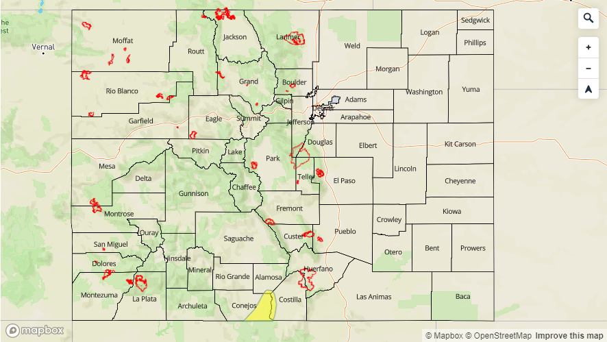
Today’s Flood Threat Map
For more information on today’s flood threat, see the map below. For Zone-Specific forecasts, scroll below the map.

Zone-Specific Forecasts:
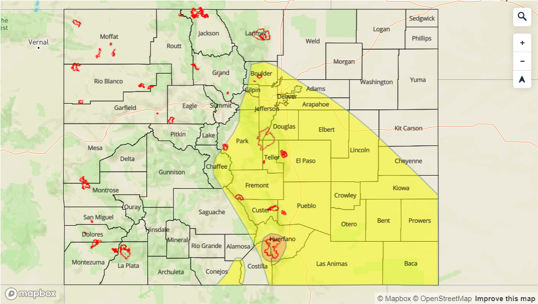
Front Range, Southeast Mountains, Raton Ridge, Palmer Ridge, Urban Corridor, Northeast Plains, Southeast Plains:
Afternoon storms are expected to fire over the Front Range foothills early this afternoon with activity spilling into the Urban Corridor. Max 1-hr rain rates up to 0.3 inches (west) and 0.45 inches (east) are possible. Severe storms along a dry line are possible near the Kansas border. Threats include hail up to 1.5 inches, strong winds and moderate rainfall. A second set of storms with the surge of the cold front south will occur overnight. Severe storms will be possible again over the Northeast Plains with max 1-hr rain rates up to 1.75 inches possible. A Low flood threat has been issued with field ponding, road, arroyo and small stream flooding possible. Weak thunderstorms and showers will be likely over the mountains and adjacent plains this evening as well as the front drops south. For the most part, 1-hr rain rates will remain below 0.15 inches.
Primetime: 1PM to 2AM
San Juan Mountains, San Luis Valley, Northern Mountains, Central Mountains, Northwest Slope, Grand Valley, Southwest Slope:
Not much rainfall expected except a sprinkle or two over the Northern Mountains. However, another warm day for the southern portions of these regions mean runoff continues. A Flood Watch is in place for portions of the San Juan Mountains and San Luis Valley citing rapid snowmelt causing creeks, streams and rivers to run high and fast with minor flooding reports. The watch remains in effect through Wednesday morning. There are currently Flood Warnings for the following: portions of the San Antonio and Conejos Rivers, Rio Grande River near Del Norte and in southern Mineral County along highway 160 between mile markers 160 and 161 near Wolf Creek Pass. Areal Flood Advisories are issued for the following: Gunnison River above Grand Junction, Manco River near Mancos and the La Plata River at Hesperus. Several other flood statements can be found at NWS Pueblo. Follow them for the latest updates on the daily runoff and river stages.