Issue Date: Friday, June 7th, 2019
Issue Time: 8:45AM MDT
–A LOW flood threat has been issued for portions of the San Antonio and Conejos Rivers
As the next system starts to approach from the west, Colorado’s upper level flow turns more southwesterly this afternoon. This will help eject some mid-level energy seen the water vapor imagery below over the state (orange “X”). Paired with an incoming jet, extra upper dynamics should produce more widespread showers over the mountains this afternoon (when compared to yesterday) with activity transitioning into the adjacent plains by early afternoon. The one catch is moisture. To the west, low relative humidity values should keep the accumulation of rainfall along and near the Continental Divide with broken cloud cover elsewhere. A Red Flag Warning is in place for the Grand Valley and northern Southwest Slope as gusty surface winds from the approaching trough will produce relative humidity less than 15% and winds greater than 25 mph for a period greater than 3 hours.
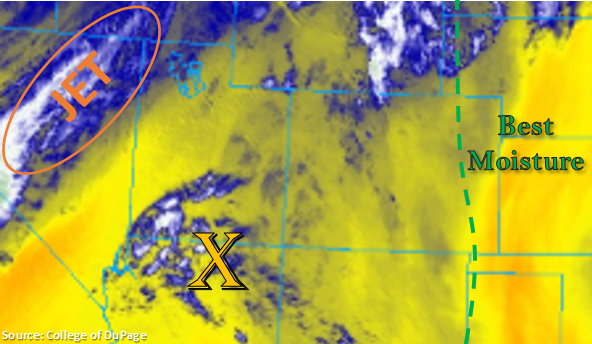
There is a bit more moisture to the east, so storms will be more numerous over the Front Range and Southeast Mountains. However with high bases, not expecting much rainfall until they transition east of the green line below. A few severe storms are possible over the Northeast Plains and eastern Palmer Ridge area with large hail, strong winds and brief, heavy rainfall being the main threats. Max 1-hr rain rates will remain below flood threat criteria, so there is no flood threat issued. Expect the majority of the storms to end a couple hours after sundown, with a lingering weak thunderstorm possible through midnight due to the right entrance region of the jet moving into the area.
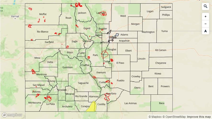
A Low flood threat has been issued for the San Antonio and Conejos Rivers, which are currently under a Flood Warning through Monday morning for minor flooding.
Today’s Flood Threat Map
For more information on today’s flood threat, see the map below. For Zone-Specific forecasts, scroll below the map.

Zone-Specific Forecasts:
Front Range, Southeast Mountains, Raton Ridge, Palmer Ridge, Urban Corridor, Northeast Plains, Southeast Plains:
Forecasting storms to begin to fire over the mountains early this afternoon and move into the adjacent plains with northeast movement by mid-afternoon. To the west, limited moisture will keep rain rates below 0.25 inches/hour. However, once the storms are able to reach east of 104°W, most moisture will increase rain rates and instability. Expecting max 1-hr rain rates up to 0.8 inches with isolated 24-hour totals around 1 inch possible over the Palmer Ridge/Northeast Plains intersect. Severe storms are also possible with strong gusts, hail up to 1.5 inches and local heavy rainfall being the main threats.
Primetime: 12PM to Midnight
San Juan Mountains, San Luis Valley, Northern Mountains, Central Mountains, Northwest Slope, Grand Valley, Southwest Slope:
Not a ton of moisture in this area, so rainfall will mostly be confined to near the Continental Divide over the Central Mountains with increasing cloud cover elsewhere this afternoon. Totals up to 0.4 inches will be possible, although 0.25-0.3 inches is a more likely range. A Red Flag Warning is in place through 9PM for the Grand Valley and northern Southwest Slope, so please use caution with any open flames.
The Low flood threat and Flood Warning by the NWS continues through Monday for portions of the San Antonio and Conejos Rivers with minor flooding forecast. Additional Areal Flood Advisories for the Gunnison River above Grand Junction, the La Plata River at Hesperus and for the Mancos River in Montezuma County for minor lowland flooding have been issued. These advisories will continue until further notice by the NWS. Minor flooding has not reported at any of these locations, although rivers remain at or slightly above bankfull, which makes the banks unstable.
Primetime: 1PM to 6PM