Issue Date: Wednesday, June 5th, 2019
Issue Time: 9:10AM MDT
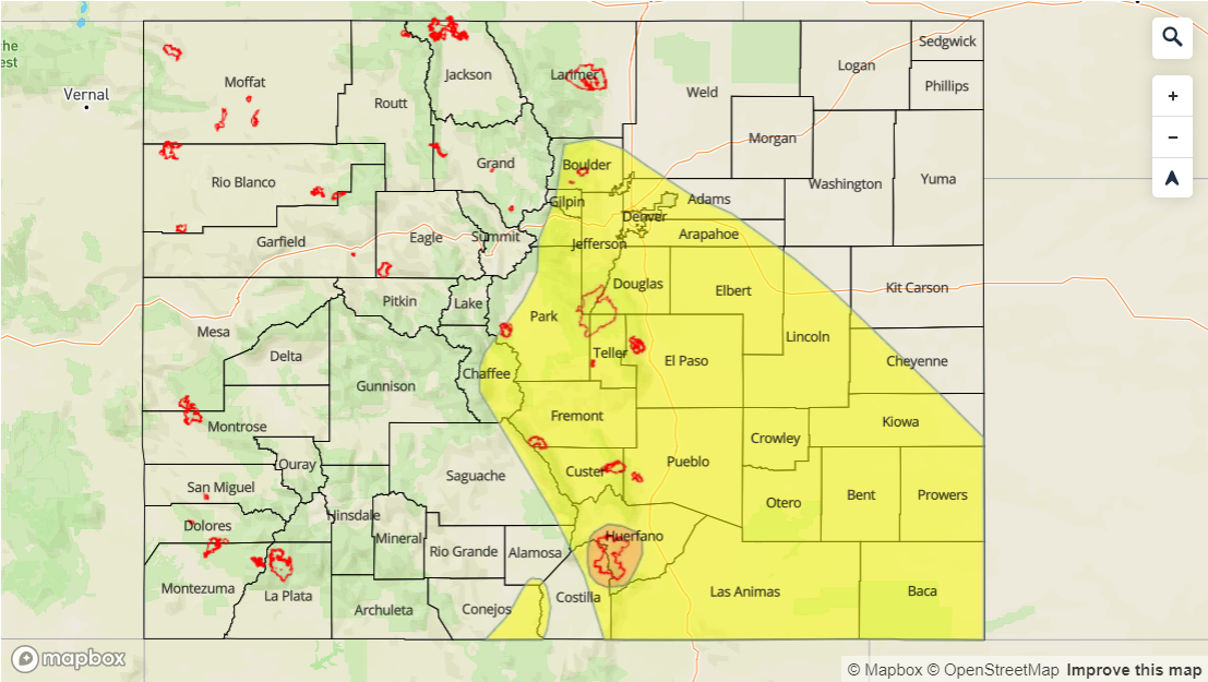
–A MODREATE flood threat has been issued for the Spring Creek burn area
–A LOW flood threat has been issued for the Southeast Mountains, Palmer Ridge, Raton Ridge, Southeast Plains, portions of the Front Range and Urban Corridor, and the Junkins and Hayden Pass burn areas
–A LOW flood threat has been issued for San Antonio and Conejos Rivers
The aforementioned cutoff upper low begins to move eastward today, just south of Colorado’s border. Currently, the low can be seen in the water vapor imagery below centered over central Arizona/New Mexico. By late tonight, the low is forecast to be over the Texas panhandle. As the low moves to the east, it will start to pull in the high moisture values to the east of the green line below on its east and north side. This will increase dew points the most over the Southeast Plains, Raton Ridge, Southeast Mountains, Palmer Ridge and San Luis Valley as flow at the surface becomes more easterly early this afternoon. This morning PW was measured at 0.63 inches in the Denver sounding. The increase in upslope flow, low level moisture and slow steering winds will allow heavy rainfall to occur over the Southeast Mountains, Palmer Ridge and Raton Ridge this afternoon and evening with multiple rounds of rain possible. While moisture won’t be quite as deep over the Front Range and Urban Corridor, slow steering winds will allow more rainfall to accumulate and small hail may cause issues over populated areas. A Low flood threat has been issued for this area, and a Moderate flood threat has been issued for the Spring Creek burn area as last year, it only took 1-hour rain rates as low as 0.3 inches to trigger mud flows, debris slides and flash flooding. The Junkins and Hayden Pass burn areas should also be monitored closely for flash flooding/debris slides and fall within the Low flood threat.

Expecting storms to start firing west to east today over the mountains with the diurnal flow and approaching low increasing coverage of storms. The highest concentrations of showers and thunderstorms will be over the higher terrains favoring the peaks east of the Continental Divide and the San Juan Mountains. This also includes the Raton and Palmer Ridges. An isolated severe thunderstorm or two are additionally forecast over the Southeast Plains, which will be supported by the low moving to the east and a stronger convective environment. Even the San Luis Valley will be getting in on the action, which could cause already high rivers to produce minor flooding. A Low flood threat has been issued for the San Antonio and Conejos Rivers, which are currently under a Flood Warning through Thursday morning. Storms this afternoon and evening are expected to end around midnight with atmospheric cooling and subsidence behind the low. For more details, see the Zone-Specific forecasts below.
Today’s Flood Threat Map
For more information on today’s flood threat, see the map below. For Zone-Specific forecasts, scroll below the map.

Zone-Specific Forecasts:
Front Range, Southeast Mountains, San Juan Mountains, San Luis Valley, Southeast Plains, Raton Ridge, Palmer Ridge, Urban Corridor:
With an increase in low level moisture expected this afternoon along with favorable mid-level dynamics, widespread showers and thunderstorms are expected. Slow steering winds and continuous development will cause a Low flood threat for these regions. The threat has been extended to the Southeast Plains as a couple severe storms will be possible, which would be capable of producing 1.25 inch hail, strong winds and heavy rainfall. A Moderate flood threat has been issued for the Spring Creek burn area with the Junkins and Hayden Pass burn areas falling within the Low threat. Additionally, a Low flood threat has been issued for portions of the San Antonio and Conejos Rivers with rain expected over the San Luis Valley this afternoon and evening. A Flash Flood Watch is effect for the Southeast Mountains through this evening for recent burn areas. Max 1-hr rain rates are the following:
Southern Front Range, Southeast Mountains and Urban Corridor: 0.75 to 1 inch
Southeast Plains, Raton Ridge and Palmer Ridge: 1 inch (west) to 1.4 inches (east) with isolated 24-hr totals up to 2.2 inches over the SE Plains possible
San Luis Valley: 0.5 inches with 24-hour totals up to 0.75 inches
Primetime: 11:30AM to Midnight
Northern Mountains, Central Mountains, Northwest Slope, Grand Valley, Southwest Slope, Northeast Plains:
Not quite as much moisture or upper level dynamics affecting these areas. A few mountain storms could wander into the adjacent lowlands with southwesterly storm movement. Accumulations are forecast to be under 0.1 inches for these storms. Max 1-hr rain rates up to 0.2 inches (north) and 0.4 inches (south) are possible. Main threats will be gusty winds, small hail and lightning. Flooding is not forecast.
Primetime: 12PM to 11PM