FTB 06-28-2019: Light Precipitation over the Southwest and Central Mountains & Hot Temperatures Statewide

Issue Date: Friday, June 28th, 2019
Issue Time: 10:55 AM MDT

—Flooding is NOT expected today

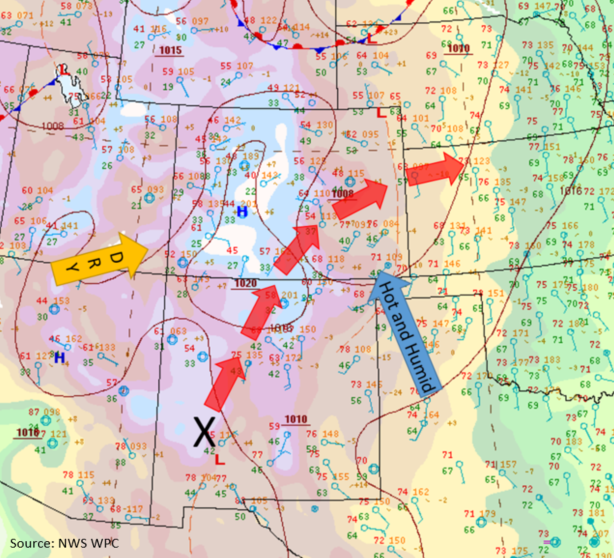
Colorado’s weather pattern has not changed much over the last few days. Upper level flows remain weak out of the southwest (blue arrow in image below), with mid-level moisture slowly creeping its way into the state throughout the day and into tomorrow morning. High pressure remains centered over the high country, providing downslope flow throughout the morning and into the early afternoon (yellow surface streamlines).  A broad region of low pressure sits over the eastern plains advecting in hot, semi-moist air to the far eastern plains. These two features will converge, creating a dryline over the area by this afternoon.  Moisture arriving from the east will mix out throughout the day, keeping skies clear and precipitation chances negligible.

Southerly to southwesterly flow along the New Mexico and Utah boarders will bring in hot, relatively moist air at the surface, providing rain chances for this afternoon and early evening. A weak, mid-level shortwave and local vorticity maximum will move over the southern edge of the state early this evening, helping provide lift to weak thunderstorms. Moisture will be primarily in the lower and mid-levels, but high-based thunderstorms are expected over the southwest quadrant of the state later this afternoon and evening.  Additional storm activity over the southern Front Range and Central Mountains will initiate with residual moisture under the ridge by midday. Activity will likely move into the adjacent plains over the southern Urban Corridor, Palmer Ridge and Raton Ridge areas. Flooding is not forecast.

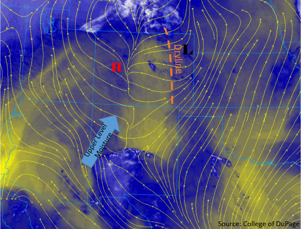
Surface temperatures are expected to increase slightly from yesterday’s values over the eastern plains. Downsloping flow and sunny skies this morning will allow temperatures to increase rapidly. Highs in the mid 100°Fs are forecast for the Southeast Plains, with temperatures in the 90°Fs for most areas west of the foothills. Over the high country, high temperatures are expected to be in the 80°Fs once again, decreasing down into the 60°Fs over the highest elevations. The Grand Valley is also forecast to be in the 90°Fs and dry at the surface.

Today’s Flood Threat Map

For more information on today’s flood threat, see the map below.  For Zone-Specific forecasts, scroll below the map.


Zone-Specific Forecasts:

Southwest Slope, San Juan Mountains, Central Mountains, Grand Valley, Front Range, Urban Corridor, Southeast Mountains, Raton Ridge, Palmer Ridge

High-based, weak thunderstorms and showers are forecast for this afternoon into tonight.  Southwest flow and a mid-level shortwave will create lift for thunderstorms over the southwest corner of the state.  Diurnal flow will provide lift and forcing for showers and thunderstorms over the Front Range, and Central Mountains by midafternoon.  Most precipitation is expected to evaporate prior to reaching the surface, so most surface accumulation will be light or confined to the upper elevations.  Maximum 1-hour accumulations of 0.3 inches are expected over the San Juan and Central Mountains, with maximum 1-hour accumulations of 0.15 inches over the Front Range, Urban Corridor and Palmer Ridge.  Gusty winds (up to 35 mph) are expected near the storms vicinity once again today.  Thunderstorm and light rainfall may last a couple hours after sundown with the shortwave overhead, but activity should end as instability decreases.

Primetime: 2PM to 12AM

Northwest Slope, Northern Mountains, Northeast Plains, Palmer Ridge, Southeast Plains, San Luis Valley

Conditions will be hot and dry over the area today, with little to no precipitation expected as storms will dissipate as they move east away from the lifting source and into drier air.  Morning downsloping winds and warm air advection will keep these regions hot and dry.  Snowmelt will continue for another day, but river levels remain steady and below Action stage over the Northern Mountains.


FTB 06-27-2019: Isolated, Weak Showers to the South and East and Hot Temperatures Statewide

Issue Date: Thursday, June 27, 2019
Issue Time: 10:40 AM MDT

Flooding is NOT expected today

Upper level flow over Colorado remains from the southwest, as a ridge continues to build to the east and the trough further deepens back to the west.  At the surface, high pressure has expanded back to the west, which will keep rainfall chances low west of the Continental Divide (see the surface map below). Due to high temperatures, low relative humidity and gusty winds a Red Flag Warning remains in effect for  the Grand Valley and Southwest Slope below 6500 ft.

The shortwave and surface low that brought rain to the Northeast Plains yesterday remains over the northeast corner of the state this morning.  This feature, along with high pressure centered over the Mississippi Valley, will bring hot temperatures and some decent low-level moisture to the eastern plains throughout the day (blue arrow).  Dew points over the eastern plains this morning are up to 60°F and decrease back to the west, measuring in the 30°Fs along the foothills.  PW measurements are less than 0.5 inches over most of the state, with Denver’s morning sounding measuring only 0.39 inches this morning.  With atmospheric moisture once again lacking statewide, showers and thunderstorms should be confined to over the southern half of the state. Later today, a shortwave (marked by X below) will move into the southern half of the state and help initiate some weak, high-based thunderstorms with the diurnal flow over the southern high terrains and Palmer Ridge.  A couple additional storms may be possible over the Southern Front Range with activity likely spreading into the Urban Corridor as the weak disturbance moves east.  Accumulations will remain light, with the main threat once again being gusty winds. Thunderstorms are forecast to begin in the early afternoon and end late this evening.  Storm motion will be eastward around 25 mph.  Flooding is not forecast.

No riverine flooding is expected today.  Waters retreated from Action stage on the Arkansas River at La Junta early yesterday. The only gage statewide remaining at Action level is the Rio Grande River near Alamosa. With water levels steady and no flood reports yesterday, no threat has been issued.

Today’s Flood Threat Map

For more information on today’s flood threat, see the map below.  For Zone-Specific forecasts, scroll below the map.


Zone-Specific Forecasts:

San Juan Mountains, San Luis Valley, Southeast Mountains, Southeast Plains, Raton Ridge, Central Mountains, Palmer Ridge, Front Range, Urban Corridor, Northeast Plains:

Warm air advection from the south and mostly sunny skies will increase high temperatures today over the area.  Temperatures are forecast to be in the 90°Fs over the eastern plains and may creep into the 100°Fs over the Southeast Plains. Over the high country, temperatures will reach into the 80°Fs in the valleys, with temperatures in the 60°Fs over the higher elevations.  Precipitation will begin near the CO-NM border, with storms to the north initiating a few hours later.  For today, max 1-hr rain rates up to 0.5 inches (SE plains & Raton Ridge), 0.4 inches (southern mountains) and 0.2 inches (Front Range & Central Mountains) will be possible under the stronger storms. Air below cloud base will remain dry, causing gusts up to 40 mph with Inverted-V soundings.  There isn’t a huge concern for flash flooding over recent burn areas, though storms that track over the Spring Creek Burn Area should be monitored closely.

Primetime: 12PM to 11:30PM

Southwest Slope, Grand Valley, Northwest Slope, Northern Mountains:

Repeat pattern underway with hot temperatures, sunny skies and gusty winds over the area. The dry air and wind combination today are anticipated to heighten fire danger to critical levels over the Southwest Slope and Grand Valley today below 6500 ft.  A Red Flag Warning is in place once again. Gusts up to 35 mph are possible throughout the day with surface wind speeds between 20 and 25 mph.  Temperatures are again expected to climb into the low 90°Fs in Grand Valley, with temperatures in the 70°Fs and 80°Fs over the high country.  No precipitation is expected today.

FTB 06-26-2019: Weak Afternoon Thunderstorms Anticipated Over the Eastern Plains

Issue Date: Wednesday, June 26th, 2019
Issue Time: 10:05AM MDT

–Flooding is NOT expected today

Flow aloft over the state has turned to the southwest as the trough off the Pacific coast begins to deepen. Currently there is some cloud cover over the mountains and southwest corner of the state associated with some mid-level energy moving through the area. With shallow moisture in place again today, expecting these clouds to burn off after a couple hours of heating. Marked in green below is the dew point gradient. As noted the last couple of days, a very dry air mass remains over western Colorado. With a tightening pressure gradient aloft, surface winds will likely pick up to the 15-20 knot range along the western border today. This will increase fire danger, although critical fire weather is not anticipated until tomorrow. Some light showers may be possible over the southern San Juan Mountains this afternoon as the shortwave (marked in orange below) helps kick off some high-based, weak thunderstorms. The shortwave and diurnal flow will also help initiate some showers and weak thunderstorms over the eastern mountains with the main activity centered over the southern Front Range and Palmer Ridge. As storms move off the mountains into the adjacent plains, only light rainfall is anticipated. Threats also include brief gusty winds, similar to yesterday.

A lee trough is expected to setup over the Northeast Plains and will tighten the dew point gradient (dry line). This will produce some convergence for storm initiation over the eastern plains this afternoon in a north/south oriented line east of Highway 71. Better moisture will be located over Nebraska and Kansas, so the main threat for storms today will again be gusty winds, severe hail and moderate rainfall. Storm activity will move east of the border by early this evening. Therefore, flooding is not expected.

Another day with no riverine flooding expected as well. While a couple gages remain at Action stage, streamflow levels are predicted to decrease statewide. Thus, since no flooding was reported yesterday, there is no riverine flood threat issued today. For the most up to date information on the riverine flooding threat, follow your local NWS Weather Forecast Office.

Today’s Flood Threat Map

For more information on today’s flood threat, see the map below. For Zone-Specific forecasts, scroll below the map.

Zone-Specific Forecasts:

Front Range, Southeast Mountains, Raton Ridge, Urban Corridor, Northeast Plains, Palmer Ridge, Southeast Plains:

High temperatures will continue to creep up a couple of degrees today with the 5880mb ridge pushing north thanks to warm air advection. Highs over the Southeast Plains will reach just under the 100°F mark. Feeling more like summer! For storms today, max 1-hour rain rates up to 0.15 inches (west) and 0.6 inches (east) will be possible under the stronger storms. Thus, brief gusty winds will also be possible again with Inverted-V soundings. Over the eastern plains, storms will be capable of producing stronger gusts (up to 50 mph), hail up to 1.5 inches and dangerous lightning. These threats should end by the early evening as activity moves east of the state. Flooding is not anticipated.

Primetime: 1PM to 9PM

San Juan Mountains, Northern Mountains, Central Mountains, Northwest Slope, Grand Valley, Southwest Slope, San Luis Valley:

Low dew points and increasing surface winds will escalate fire danger this afternoon. Critical fire weather is not anticipated until tomorrow, but be sure to use caution with any open flame. Surface winds in the 15-20 knot range are anticipated to mix to the surface with gusts between 30 and 35 knots possible by later this afternoon. Winds will then decrease overnight. High temperatures today will be similar to yesterday with an increase in afternoon cloud cover as the shortwave passes overhead. Very light showers may be possible over the southern San Juan Mountains, but the weak storms will likely only produce gusty winds and a drop or two of rain.

Primetime: 2PM to 7PM

FTB 06-25-2019: High-Based Storms for Central Colorado & Rising High Temperatures Statewide

Issue Date: Tuesday, June 25th, 2019
Issue Time: 9:05AM MDT

–Flooding is NOT expected today

The main weather story today will be warmer temperatures with highs expected to be 5-10°F greater than yesterday. Currently, flow aloft is westerly (west) and northwesterly (east). As the ridge begins to build northward over Wyoming today, flow will gradually turn from the southwest statewide. The southwesterly and westerly surface flow this morning is expected to entrain a dry air mass over southern Colorado. This will push the dry line (dashed green in the water vapor imagery below) eastward throughout the day and help mix out the shallow low-level moisture present over eastern Colorado. This should inhibit most of the storm activity over the southern high terrains as dew points to the east of this line are in the 30°Fs.

Approaching from the west is a weak shortwave, which is marked with the orange “X” in the image below. The arrival of this wave during peak heating, should help kick off some weak thunderstorms and high-based showers over the central mountains and Palmer Ridge areas. PW values at DIA this morning were measured at 0.52 inches. Storm activity is forecast to spread into the adjacent, eastern plains by mid-afternoon. However, storms today will produce little, if any, rainfall accumulations due to the aridness of the atmosphere and quick storm motion. The main threat with storms today will be gusty outflow winds (up to 55mph) and lightning. A little better moisture will be able to hang on over the northeast corner of the state, so if storms that form over the Cheyenne Ridge track into the area, expect some light accumulation. Flooding is not forecast today.

The riverine flood threat has ceased for the moment with river levels forecast to drop statewide or remain below Action stage. The one exception is along the Arkansas River at La Junta. High water from Avondale will continue to traverse east and may cause the AHPS gage to briefly reach Minor flooding stage. This is not expected to last long, so no flood threat has been issued. For the most up to date information on the riverine flooding threat, follow your local NWS Weather Forecast Office.

Today’s Flood Threat Map

For more information on today’s flood threat, see the map below. For Zone-Specific forecasts, scroll below the map.

Zone-Specific Forecasts:

Front Range, Southeast Mountains, Raton Ridge, Urban Corridor, Northeast Plains, Palmer Ridge, Southeast Plains, Central Mountains:

High temperatures today over the eastern plains could reach the mid 90°Fs with 80°Fs along the Urban Corridor. Most mountainous regions should reach the upper 60°Fs to low 70°Fs. Storms today will be capable of producing 1-hour totals up to 0.1 inches (east) and 0.35 inches (northwest corner). However, the majority of storms will produce only trace amounts with strong outflow winds. Light overnight showers may be possible over the Southeast Plains, but flooding is not anticipated. Lastly, expect a crest at the La Junta gage along the lower Arkansas River, which may briefly push the gage into Minor flooding.

Primetime: 1PM to 11PM

San Juan Mountains, Northern Mountains, Northwest Slope, Grand Valley, Southwest Slope, San Luis Valley:

Another day with very low dew points. Thankfully surface winds should be rather light, so not anticipating any critical fire weather. Cloud cover is anticipated this afternoon over the high terrains as the shortwave pushes east, but rainfall accumulation above 0.05 inches is not forecast. At this time, there is no riverine flooding anticipated although the Rio Grande gage at Alamosa and North Platte River gage at Northgate are in Action stage.

Primetime: 1PM to 9PM