Issue Date: Thursday, June 27, 2019
Issue Time: 10:40 AM MDT
—Flooding is NOT expected today
Upper level flow over Colorado remains from the southwest, as a ridge continues to build to the east and the trough further deepens back to the west. At the surface, high pressure has expanded back to the west, which will keep rainfall chances low west of the Continental Divide (see the surface map below). Due to high temperatures, low relative humidity and gusty winds a Red Flag Warning remains in effect for the Grand Valley and Southwest Slope below 6500 ft.
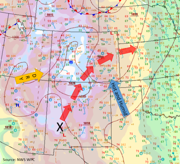
The shortwave and surface low that brought rain to the Northeast Plains yesterday remains over the northeast corner of the state this morning. This feature, along with high pressure centered over the Mississippi Valley, will bring hot temperatures and some decent low-level moisture to the eastern plains throughout the day (blue arrow). Dew points over the eastern plains this morning are up to 60°F and decrease back to the west, measuring in the 30°Fs along the foothills. PW measurements are less than 0.5 inches over most of the state, with Denver’s morning sounding measuring only 0.39 inches this morning. With atmospheric moisture once again lacking statewide, showers and thunderstorms should be confined to over the southern half of the state. Later today, a shortwave (marked by X below) will move into the southern half of the state and help initiate some weak, high-based thunderstorms with the diurnal flow over the southern high terrains and Palmer Ridge. A couple additional storms may be possible over the Southern Front Range with activity likely spreading into the Urban Corridor as the weak disturbance moves east. Accumulations will remain light, with the main threat once again being gusty winds. Thunderstorms are forecast to begin in the early afternoon and end late this evening. Storm motion will be eastward around 25 mph. Flooding is not forecast.
No riverine flooding is expected today. Waters retreated from Action stage on the Arkansas River at La Junta early yesterday. The only gage statewide remaining at Action level is the Rio Grande River near Alamosa. With water levels steady and no flood reports yesterday, no threat has been issued.
Today’s Flood Threat Map
For more information on today’s flood threat, see the map below. For Zone-Specific forecasts, scroll below the map.
Zone-Specific Forecasts:
San Juan Mountains, San Luis Valley, Southeast Mountains, Southeast Plains, Raton Ridge, Central Mountains, Palmer Ridge, Front Range, Urban Corridor, Northeast Plains:
Warm air advection from the south and mostly sunny skies will increase high temperatures today over the area. Temperatures are forecast to be in the 90°Fs over the eastern plains and may creep into the 100°Fs over the Southeast Plains. Over the high country, temperatures will reach into the 80°Fs in the valleys, with temperatures in the 60°Fs over the higher elevations. Precipitation will begin near the CO-NM border, with storms to the north initiating a few hours later. For today, max 1-hr rain rates up to 0.5 inches (SE plains & Raton Ridge), 0.4 inches (southern mountains) and 0.2 inches (Front Range & Central Mountains) will be possible under the stronger storms. Air below cloud base will remain dry, causing gusts up to 40 mph with Inverted-V soundings. There isn’t a huge concern for flash flooding over recent burn areas, though storms that track over the Spring Creek Burn Area should be monitored closely.
Primetime: 12PM to 11:30PM
Southwest Slope, Grand Valley, Northwest Slope, Northern Mountains:
Repeat pattern underway with hot temperatures, sunny skies and gusty winds over the area. The dry air and wind combination today are anticipated to heighten fire danger to critical levels over the Southwest Slope and Grand Valley today below 6500 ft. A Red Flag Warning is in place once again. Gusts up to 35 mph are possible throughout the day with surface wind speeds between 20 and 25 mph. Temperatures are again expected to climb into the low 90°Fs in Grand Valley, with temperatures in the 70°Fs and 80°Fs over the high country. No precipitation is expected today.