Issue Date: Tuesday, June 25th, 2019
Issue Time: 9:05AM MDT
–Flooding is NOT expected today
The main weather story today will be warmer temperatures with highs expected to be 5-10°F greater than yesterday. Currently, flow aloft is westerly (west) and northwesterly (east). As the ridge begins to build northward over Wyoming today, flow will gradually turn from the southwest statewide. The southwesterly and westerly surface flow this morning is expected to entrain a dry air mass over southern Colorado. This will push the dry line (dashed green in the water vapor imagery below) eastward throughout the day and help mix out the shallow low-level moisture present over eastern Colorado. This should inhibit most of the storm activity over the southern high terrains as dew points to the east of this line are in the 30°Fs.
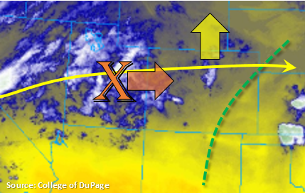
Approaching from the west is a weak shortwave, which is marked with the orange “X” in the image below. The arrival of this wave during peak heating, should help kick off some weak thunderstorms and high-based showers over the central mountains and Palmer Ridge areas. PW values at DIA this morning were measured at 0.52 inches. Storm activity is forecast to spread into the adjacent, eastern plains by mid-afternoon. However, storms today will produce little, if any, rainfall accumulations due to the aridness of the atmosphere and quick storm motion. The main threat with storms today will be gusty outflow winds (up to 55mph) and lightning. A little better moisture will be able to hang on over the northeast corner of the state, so if storms that form over the Cheyenne Ridge track into the area, expect some light accumulation. Flooding is not forecast today.
The riverine flood threat has ceased for the moment with river levels forecast to drop statewide or remain below Action stage. The one exception is along the Arkansas River at La Junta. High water from Avondale will continue to traverse east and may cause the AHPS gage to briefly reach Minor flooding stage. This is not expected to last long, so no flood threat has been issued. For the most up to date information on the riverine flooding threat, follow your local NWS Weather Forecast Office.
Today’s Flood Threat Map
For more information on today’s flood threat, see the map below. For Zone-Specific forecasts, scroll below the map.
Zone-Specific Forecasts:
Front Range, Southeast Mountains, Raton Ridge, Urban Corridor, Northeast Plains, Palmer Ridge, Southeast Plains, Central Mountains:
High temperatures today over the eastern plains could reach the mid 90°Fs with 80°Fs along the Urban Corridor. Most mountainous regions should reach the upper 60°Fs to low 70°Fs. Storms today will be capable of producing 1-hour totals up to 0.1 inches (east) and 0.35 inches (northwest corner). However, the majority of storms will produce only trace amounts with strong outflow winds. Light overnight showers may be possible over the Southeast Plains, but flooding is not anticipated. Lastly, expect a crest at the La Junta gage along the lower Arkansas River, which may briefly push the gage into Minor flooding.
Primetime: 1PM to 11PM
San Juan Mountains, Northern Mountains, Northwest Slope, Grand Valley, Southwest Slope, San Luis Valley:
Another day with very low dew points. Thankfully surface winds should be rather light, so not anticipating any critical fire weather. Cloud cover is anticipated this afternoon over the high terrains as the shortwave pushes east, but rainfall accumulation above 0.05 inches is not forecast. At this time, there is no riverine flooding anticipated although the Rio Grande gage at Alamosa and North Platte River gage at Northgate are in Action stage.
Primetime: 1PM to 9PM