Issue Date: Wednesday, August 7, 2019
Issue Time: 10:30AM MDT
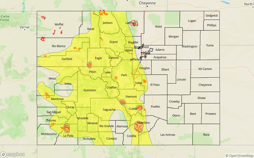
–A MODERATE flood threat has been issued for the 416 burn area
–A LOW flood threat has been issued for the Northeast Plains and portions of the Palmer Ridge, Southeast Plains, Southwest Slope, San Juan Mountains, Grand Valley and Central Mountains. This includes the Spring Creek burn area.
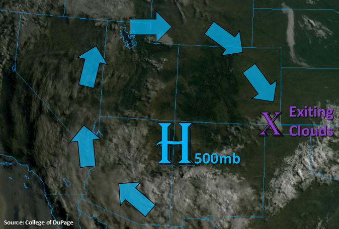
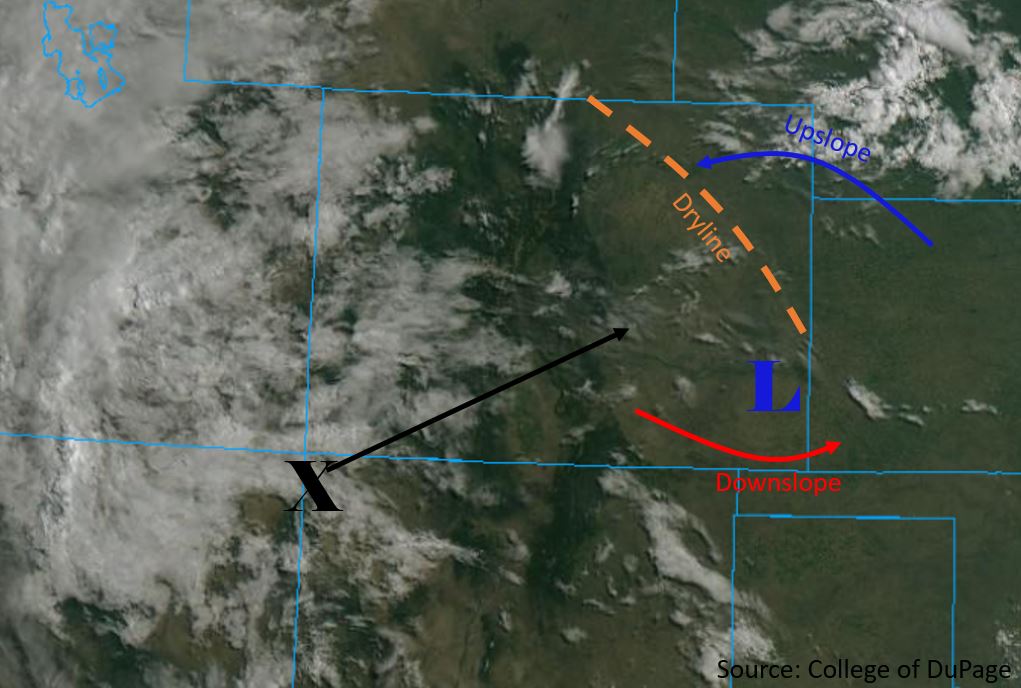
A monsoonal moisture surge will occur over western Colorado today as the subtropical high moves east throughout the day, allowing advection of high PW values northward. This increase in moisture can be seen by the cloud cover over southwest Colorado in the visible satellite imagery below. Embedded within the flow is a shortwave marked by an “X”, which will make its way eastward throughout the day. The high levels of moisture coupled with this upper level dynamic forcing is forecast to cause widespread precipitation over the high country. Upper level steering flows between 10 and 15 mph over western Colorado will allow storms to sit over the Low threat area. Cloud cover associated with the approaching shortwave will likely limit instability for stronger thunderstorms. However, persistent, pulse-like storms over the area will cause some moderate 2-3 hour rainfall totals. The widespread nature of the moderate rainfall totals will cause a Low flood threat to be issued. If multiple storms track over the 416 burn scar, there is a chance for flooding due to totals in the area reaching up to 1 inch over a 2-3 hour period.
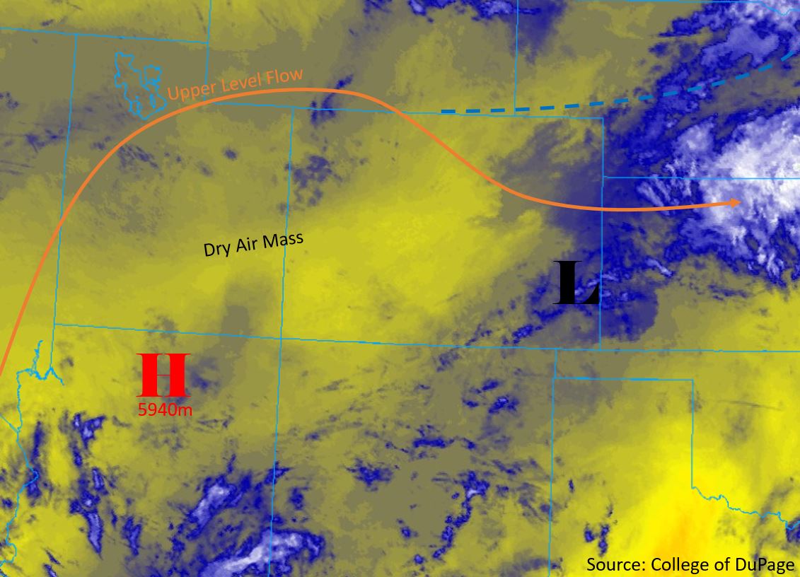
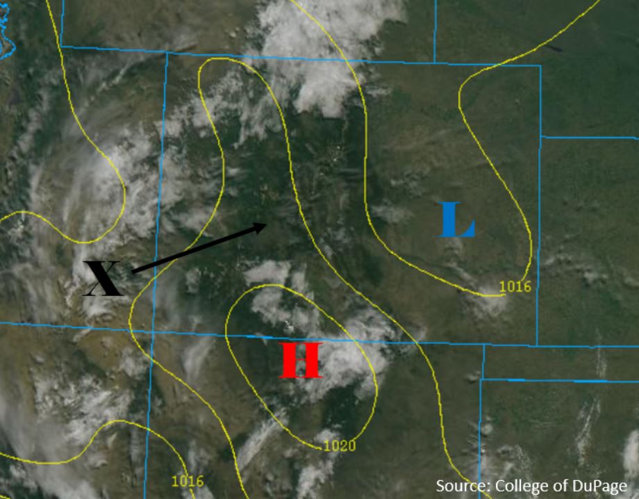
Thunderstorms are also forecast over the eastern plains, which will be generated by a surface dry line (orange dashed line below). The passage of the shortwave overhead will generate and deepen a new surface low over the area by mid-afternoon. This will help to scour out moisture along the Front Range and Southeast Mountains, so more scattered storms are anticipated over the eastern mountains with rain rates under flood threat criteria. The one exception is the Spring Creek burn area. The chances of flooding over the burn area are on the lower end of the Low threat spectrum, but storms early in the day may prime the atmosphere for 1 to 1.5 hour rainfall rates up to 0.5 inches. Higher moisture over the Northeast Plains will cause some heavy rainfall with the shortwave passing at peak heating. Storms moving between 15 and 20 mph to the southeast should be fast enough that the threat should only last for 1 to 2 hours. A couple stronger thunderstorms are possible before an MCS forms, which may cause isolated storms to produce wind gusts up to 60 mph and up to 1.25 inch diameter hail. There is a Low flood threat issued for this area.
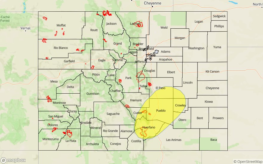
Today’s Flood Threat Map
For more information on today’s flood threat, see the map below. For Zone-Specific forecasts, scroll below the map.


Zone-Specific Forecasts:
San Luis Valley, San Juan Mountains, Southwest Slope, Grand Valley, Northwest Slope, Central Mountains, Northern Mountains:
Storms are expected over the high country throughout the afternoon and some may linger overnight over the high terrains. Heavier rainfall rates are forecast to favor the higher elevations of the Southwest Slope, San Juan Mountains, Grand Valley and southern Central Mountains. Moisture is plentiful over the western San Juan Mountains, so isolated totals up to 1.25 inches will be possible by tomorrow morning. Max 1-hour rainfall rates up to 0.8 inches are possible near the 416 burn area, so a Moderate threat has been issued. Threats over the burn area and steeper mountain slopes include mud slides, debris flows and flash flooding of small creeks and streams. Drier air to the north will limit max 1-hour rainfall rates to 0.25 inches.
Primetime: 11AM to Midnight
Front Range, Urban Corridor, Northeast Plains, Palmer Ridge, Southeast Plains, Southeast Mountains, Raton Ridge:
A line of storms are forecast over the Northeast Plains early this afternoon forming along the boundary. Expect these storms to turn into a MCS later this evening. The primary flood threat will be over a 1.5 to 2 hour period, with 1-hour max rainfall rates just under 2 inches possible. Isolated storm totals up to 2.25 inches may be possible by morning. A couple storms may form over the southeast plains off of outflow boundaries from the north and max 1-hour rainfall rates of 0.3 inches are forecast over the area. Back to the west over the mountains and adjacent northern Urban Corridor, weak thunderstorms may produce max 1-hour rainfall rates up to 0.5 inches. While there is limited moisture over the Southeast Mountains, storms will still be capable of producing rain rates up to 0.5 inches, so a Low threat has been issued for the Spring Creek burn area. Threats over the burn area (if a storm tracks directly over it) include flash flooding, debris slides and mud flows.
Primetime: 1PM to 1:30AM