Issue Date: Monday, August 5, 2019
Issue Time: 10:35AM MDT
-A LOW flood threat has been issued for portions of the Southeast Mountains and Southeast Plains, including the Spring Creek and Junkins burn areas
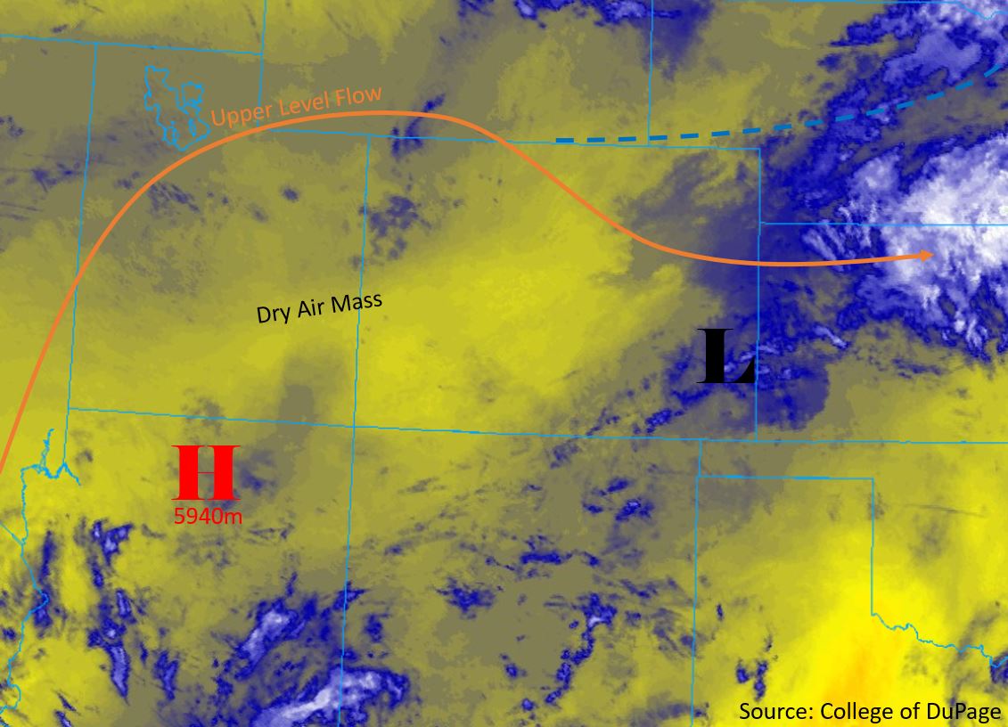
The state will dry out a bit today after widespread precipitation over the high country and Northeast Plains yesterday. Shown in the low-level water vapor imagery below, the subtropical high pressure system (marked “H”) has moved back to the west. This will cut off monsoonal moisture flow slightly and limit precipitation over western Colorado. Isolated showers are still possible over most areas, but will be light in nature. The shortwave and vorticity maximum that effected the state yesterday is now positioned over the Southeast Plains. The surface low pressure system underneath the shortwave will pull moist air down from the north, but limit upslope flow over the eastern mountain ranges this afternoon.
The highest chance for precipitation during the day will be over the Continental Divide and Northeast Plains. Weak upslope flow over the high terrain will generate light storms this afternoon. A cold front (dashed blue line) is forecast to move in from the north late this afternoon, providing chances for thunderstorms to generate off of the Cheyenne Ridge and Palmer Ridge. Fast upper level steering flows up to 30 mph will decrease the chances of moderate and heavy rainfall. Post frontal upslope flow tomorrow morning will provide heightened chances for precipitation over the Southeast Mountains and eastern areas of the Southeast Plains. A strong resurgence of moisture over the area has issued a Low flood threat. The heaviest precipitation is forecast to begin by 11PM and extends to sunrise tomorrow. Slow steering flows overnight will allow storms to linger over areas for 2-3 hours. Areas of moderate to heavy rainfall are not expected to be large, however storms centered over urban environments and burn areas create a higher risk of flooding. High levels of soil moisture over the Southeast Mountains have also increased the flood threat to a Low.
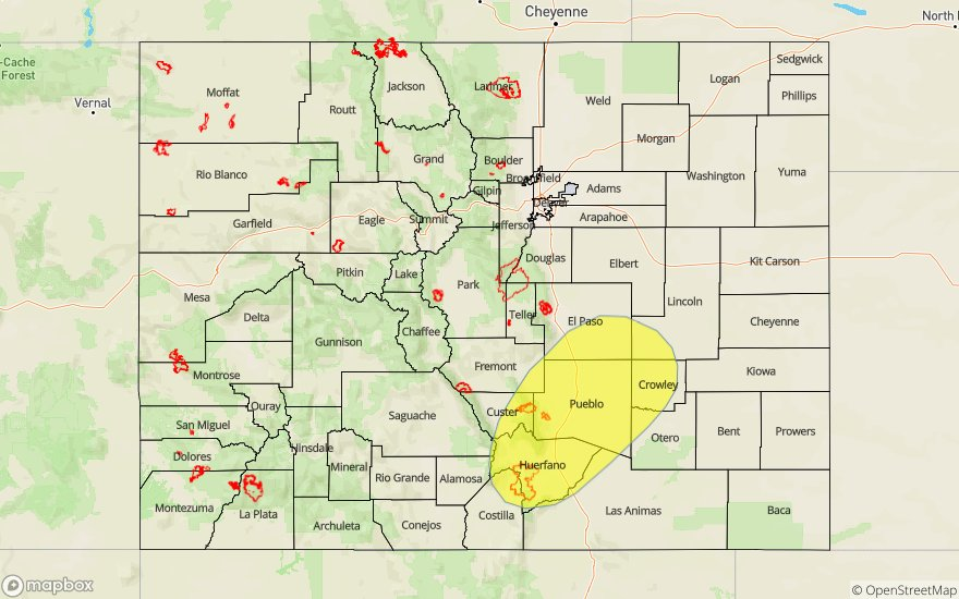
Today’s Flood Threat Map
For more information on today’s flood threat, see the map below. For Zone-Specific forecasts, scroll below the map.

Zone-Specific Forecasts:
Front Range, Urban Corridor, Northeast Plains, Palmer Ridge, Southeast Mountains, Southeast Plains, Raton Ridge:
A cold front will pass over the northern border of Colorado mid afternoon today, initiating storms over the Cheyenne ridge at that time. Isolated storms are forecast over the Northeast Plains and Palmer Ridge this afternoon and tonight, but upper level steering flows between 20 and 30 mph will prevent high accumulations over the area. Isolated max 1-hour rainfall rates up to 0.75 inches are forecast over the northern Urban Corridor, Northeast Plains and Palmer Ridge. Brief afternoon storms are forecast over the Front Range, with max 1-hour rainfall rates up to 0.3 inches. The highest chance for greater rainfall totals will be late tonight and early tomorrow morning over the Low threat area. Max 2-3 hour rainfall rates up to 1.5 inches are forecast over the area. The highest chances for flooding will be over Urban areas and recent burn areas. Max 2-3 hour rainfall rates decrease over the Spring Creek burn area to 0.75 inches. High levels of surface moisture and recent flooding over the area increase the chances for flooding over areas of the Southeast Mountains.
Primetime: 2PM to 5AM
Northwest Slope, Northern Mountains, Grand Valley, Southwest Slope, San Juan Mountains, San Luis Valley, Central Mountains:
Isolated afternoon storms are forecast over the high terrain, but fast steering flows will limit accumulation significantly. Isolated max 1-hour rainfall rates of 0.2 inches are forecast over the area today, with most of the lower elevations forecast to remain dry. Storms are expected to end over most areas early this evening, with chances extending over the Central Mountains and San Juan Mountains later into the night. Expect high temperatures to reach into the 90°Fs over the lower terrains once again today. No flooding is forecast over the area.
Primetime: 2PM to 7PM