Issue Date: Tuesday, August 6th, 2019
Issue Time: 8:45AM MDT
— Flooding is NOT expected today
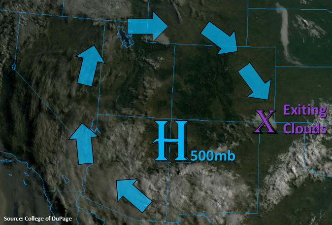
A drier air mass has worked its way into the majority of the state with the subtropical high over the New Mexico and Arizona border. This can be witnessed below (visible satellite imagery) by the lack of cloud cover over our area. Other than a few clouds over the southeast corner, which are exiting to the south as we speak, it’s a clear start to the morning. Dry air should continue to be advected in from Wyoming, which will limit afternoon showers to the southern high terrains where a bit better residual moisture can hold on and mix with some more mid-level energy for greater coverage. The scattered to isolated storms that are able to form over the northern high terrains today will be high-based, so not expecting much accumulation. Storms today will also likely produce some brief, gusty winds. Additional storms are likely over the eastern Northeast Plains/Palmer Ridge area due to convergence near the surface trough. Quick steering flows to the southeast should keep rain rates under flood threat criteria. Therefore, flooding is not forecast.
Today’s Flood Threat Map
For more information on today’s flood threat, see the map below. For Zone-Specific forecasts, scroll below the map.
Zone-Specific Forecasts:
Northwest Slope, Grand Valley, Southwest Slope, Northern Mountains, Central Mountains, San Juan Mountains, San Luis Valley:
Temperatures are on the rise. Highs today over the lower valleys are expected to crawl back into the upper 90°Fs with 80°Fs in the lower mountain valleys. Increased cloud cover is anticipated this afternoon triggered by the elevation and residual moisture. Weak storms over the Northern and Central Mountains will likely produce only trace amounts of precipitation with numerous clouds only producing a couple raindrops and occasional lightning. To the south, more continuous, pulse-like precipitation will help rain rates become more efficient throughout the day. Isolated totals up to 0.5 inches will be possible by tomorrow morning over the eastern and southern slopes of the San Juan Mountains. Rainfall rates will be rather low, so not issuing a threat for the 416 burn area. However, any storm that lingers over the burn scar should be monitored closely.
Primetime: 2PM to Midnight
Front Range, Southeast Mountains, Urban Corridor, Palmer Ridge, Raton Ridge, Northeast Plains, Southeast Plains:
The building ridge and dry air will also produce a 5-7°F rise in high temperatures today over these regions. Heaviest rainfall is anticipated over the southern Southeast Mountains and eastern plains along the Kansas and Colorado border. Isolated max 1-hour rain rates up to 0.4 inches will be possible over the Southeast Mountains/eastern Raton Ridge. With higher dew points over the eastern plains, thanks to the low level flow, max 1-hour rain rates up to 0.9 inches will be possible. The isolated storms that are able to form over the Front Range and Urban Corridor should produce only trace amounts of rain, if any at all. Mostly they’ll provide a cooling effect from the afternoon sun. Flooding is not anticipated.
Primetime: 2:30PM to 11PM