Issue Date: Sunday, August 4, 2019
Issue Time: 10AM MDT
-A MODERATE flood threat has been issued for the 416, Junkins, Spring Creek, Hayden Pass and Lake Christine burn areas
-A LOW flood threat has been issued for portions of the Southwest Slope, San Juan Mountains, Grand Valley, Northwest Slope, Northern Mountains, Front Range, Central Mountains and Southeast Mountains
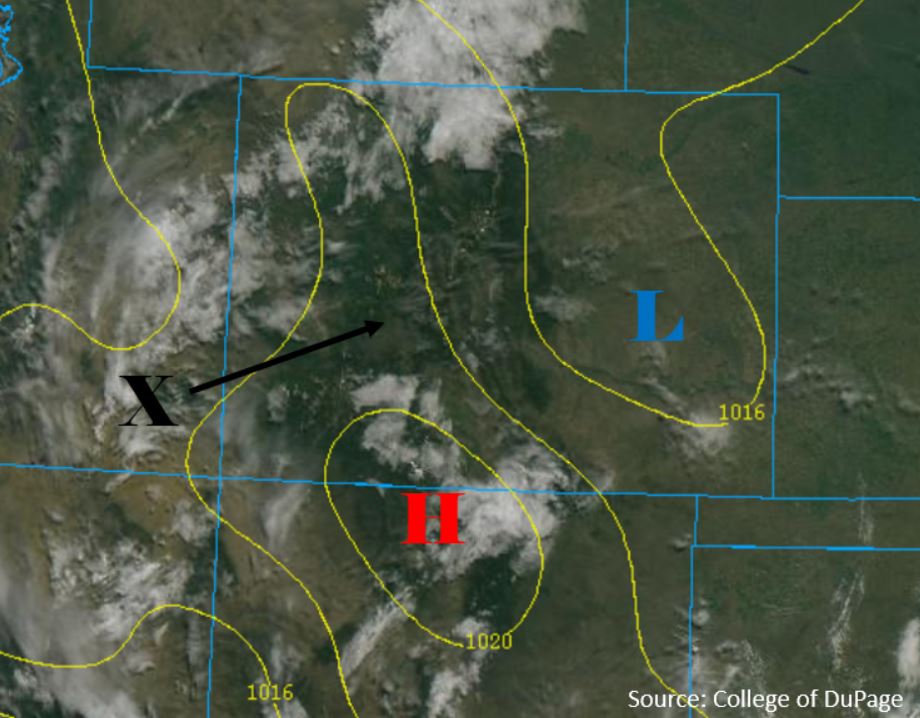
Expect similar weather statewide again today, but with a return of moisture over the northern mountain ranges and areas of the eastern plains. The subtropical high pressure remains overhead, with clockwise flow around the state once again. Embedded within the flow is a shortwave (“X” below) and local vorticity maximum that will move across Colorado today. This feature will provide lift and dynamical forcing for thunderstorms over the high country and eastern plains. Due to extra lift, rain will most likely be heavier than yesterday. Marked below on the visible satellite imagery is a surface high pressure system over the CO/NM border with a broad region of low pressure over the eastern plains. Wind flow around the two features will combine to produce downsloping flow over the Southeast Plains, creating a localized dryline over the area. This dryline will cap most storms over the Southeast Plains but provide a boundary for storms to form to the north. Thunderstorms are forecast over most of the high country as well as the Northeast Plains and Palmer Ridge.
Atmospheric moisture has increased over western Colorado from yesterday, with PW measuring 1.1 inches over Grand Junction this morning. Surface based moisture is very similar, but dewpoints over the high country have increased to the mid 40°Fs due to yesterday’s rain. Over the eastern plains surface moisture is similar to yesterday as well, but sunny skies this morning are likely to mix out low level moisture once again. The shortwave will pass over the high country during peak heating, which will create numerous thunderstorms capable of producing heavy rain. The system will arrive past the time of peak instability over the eastern plains, which should keep storms lighter. Steering flows over the mountains will vary between 10 and 20 mph, creating the primary threat of multiple storms over a 2-3 hour period. Recent rainfall over burn areas has increased the threat to Moderate over the 416, Junkins, Hayden Pass, Spring Creek and Lake Christine burn areas
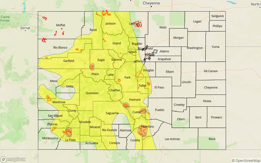
Today’s Flood Threat Map
For more information on today’s flood threat, see the map below. For Zone-Specific forecasts, scroll below the map.

Zone-Specific Forecasts:
Southwest Slope, San Juan Mountains, San Luis Valley, Grand Valley, Central Mountains, Northern Mountains, Northwest Slope:
Chances for precipitation are high throughout the area today. Heavier rainfall rates will once again favor the mountains to the south of I-70, however moderate and heavy rainfall is still possible over areas to the north. The primarily threat today is rainfall over a 2-3 hour period. Max 2-3 hour rainfall rates of 1.25 inches are forecast over the area, with rates up to 1.75 inches over the Southwest Slope and San Juan Mountains. Isolated areas of 1-hour max rainfall rates up to 1 inch are possible, but most areas will have max 1-hour rainfall rates of 0.5 inches. Rainfall will mostly be confined to higher terrain, with greater threats over steeper terrain and recent burn areas. Threats include flash flooding, debris flows and flooding of small rivers and streams.
Primetime: 11AM to 11PM
Front Range, Urban Corridor, Southeast Mountains, Raton Ridge, Southeast Plains, Palmer Ridge, Northeast Plains:
The highest chances of rainfall today will be over the Front Range and Southeast Mountains. Storms may move off of the Front Range this afternoon, but drier air underneath the storm base will limit severe weather potential over the Urban Corridor, Palmer Ridge and Northeast Plains. A few weak storms may move over the Raton Ridge this afternoon, but rainfall will be very limited as well. Max 2-3 hour rainfall rates of 1 inch are forecast over the Southeast Mountains and southern Front Range. Recent rain over the area will increase chances for flooding over these regions, with the highest chance over the recent burn areas. Threats include flash flooding, debris flows and flooding of small rivers and streams. The northern Front Range, Urban Corridor and eastern plains are expected to be drier once again today, with max 1-hour rainfall rates of 0.4 inches. The chance for measurable rain over these areas is confined to the upper elevations, Palmer Ridge and Northeast Plains.
Primetime: 1PM to 12PM