FTB 08-13-2022: Scattered Storms Forecast Mainly West, Dry And Hot East

Issue Date: Saturday, August 13th, 2022
Issue Time: 10:40 AM MDT

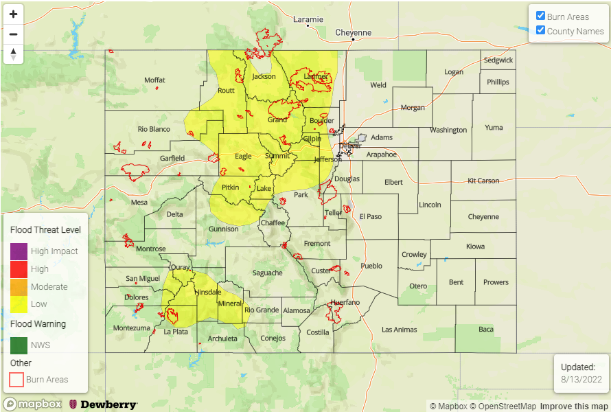
— A LOW flood threat has been issued for the Northwest Slope, Northern Mountains, Front Range, Central Mountains, San Juan Mountains, and Southwest Slope
Fire-Burn Forecast Summary: 1 burn area under HIGH threat, 3 burn areas under MODERATE threat, 2 burn areas under LOW threat; click HERE for more info 

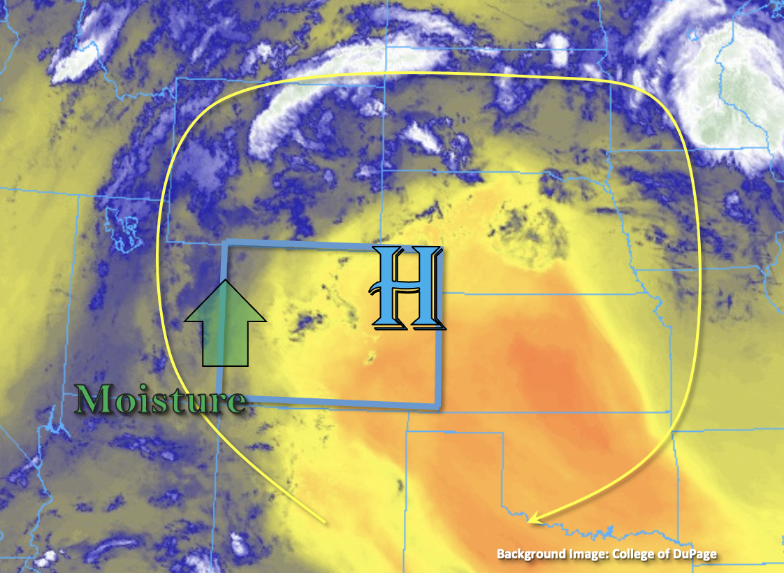
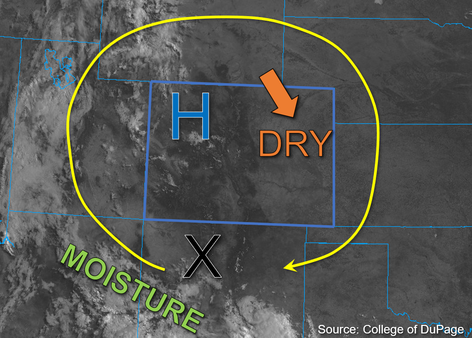
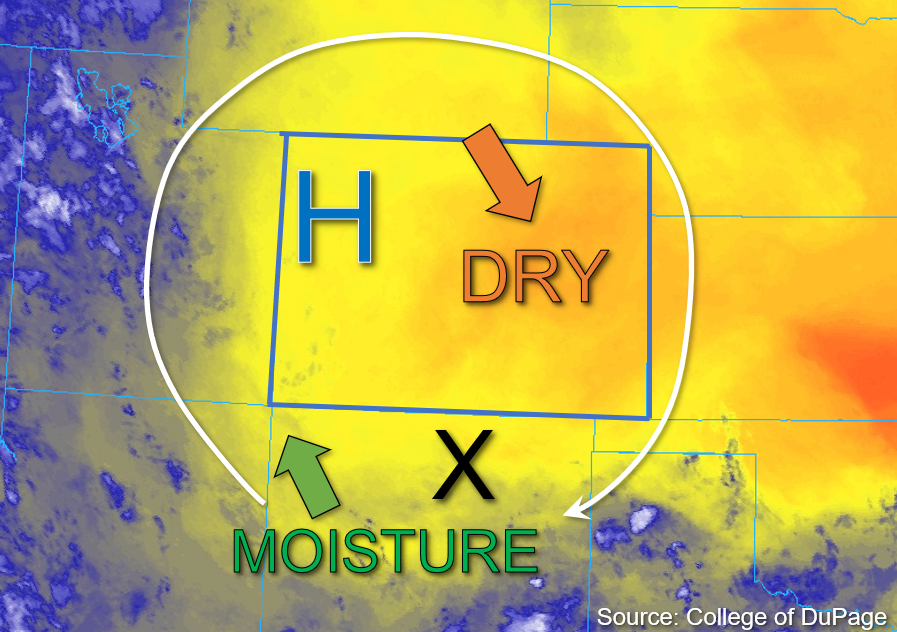
The broad, high-pressure ridge center is located over southwestern Kansas this morning and should slowly begin a slight southeastward track later this afternoon. There is an upper-level disturbance located over central Colorado that is expected to track north to northeast throughout the day and provide some added energy for storm development this afternoon. As upper-level flow shifts more westerly, modest moisture transport over the northern portions of the state is expected, while drier air moves in over the south and east. This morning, Grand Junction measured a PW value of 1.03 inches, only a slight increase from yesterday, and Platteville record a PW value of 0.89 inches, indicating sufficient column moisture. Surface moisture is modest with dew points in the mid-40s°F to low 50s°F for most of the state. Some mixing out of surface moisture is expected statewide, although moisture pooling is anticipated over north-central Colorado due to increasing upslope flow from the east and westerly flow aloft.

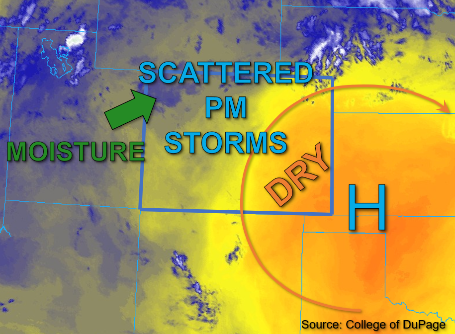
This afternoon, scattered storm development is expected primarily over the higher terrain from north-central Colorado, extending south along and west of the Continental Divide, with storms expected to move east-northeastward at about 10 to 15mph. Some training of storms is possible due to the west to southwesterly flow. By mid-afternoon, instability over north-central Colorado is forecast to reach values of 1500-2000 J/kg of CAPE, and in the presence of forecast dew points in the mid-50s°F and increased convergence over the mountains, isolated heavy rainfall will be possible with the stronger storms. Further to the southwest, slightly drier air is expected along with lesser instability, though likely sufficient for isolated heavy downpours and possible storm training this afternoon which could lead to higher storm totals. A LOW flood threat has been issued for portions of western Colorado through this evening. Eastern Colorado is expected to remain largely dry and hot except for the potential for an isolated storm or two over the Cheyenne Ridge near the Wyoming border later this afternoon.

Today’s Flood Threat Map

For more information on today’s flood threat, see the map below. If there is a threat, hover over the threat areas for more details, and click on burn areas to learn more about them. For Zone-Specific forecasts, scroll below the threat map.

Zone-Specific Forecasts: 

Northwest Slope, Northern Mountains, Front Range, Central Mountains, & Grand Valley:

A few weak early showers are dissipating over the Northwest Slope this morning, though a cloud deck remains over the far northwest corner of the state; otherwise, mostly clear skies further east should allow ample instability for scattered storm development beginning early afternoon. This development should remain confined to the higher terrain and move east to northeastward, with a few rounds of training storms possible. Isolated 1-hour rain rates up to 1.25 inches and storm totals up to 1.75 inches are possible. A LOW flood threat has been issued for portions of the Front Range, Northern Mountains, Central Mountains, and far eastern Northwest Slope. Excessive runoff, mud flows, and debris slides will be possible especially with storms that train over the steeper terrain over a couple hour period.

Primetime: 1PM to 10PM

Southwest Slope, San Juan Mountains, San Luis Valley, & Southeast Mountains:

While lesser instability and moisture is forecast over the southwest portions of the state, clouds are beginning to build over the high terrains already this morning. By the noon hour, widely scattered storm development is likely over the mountains primarily, moving northward. Training storms are possible here as well given the more southerly wind component. Max 30-minute rain rates up to 0.9 inches and 1-to-2-hour storm totals up to 1.5 inches are possible. A LOW flood threat has been issued for portions of the San Juan Mountains and eastern Southwest Slope. Excessive runoff, mud flows, and debris slides will be possible especially with storms that train over the steeper terrain over a couple hour period.

Primetime: 12PM to 9PM

Urban Corridor, Northeast Plains, Palmer Ridge, Southeast Plains, & Raton Ridge:

This morning, skies are clear and warm temperatures are expected to rise quickly into the low to mid-90s°F this afternoon. Under great influence from subsidence from the ridge and high dewpoint depressions, storms are not expected for most of the eastern half of the state. That said, a few isolated storms are possible over the northern Urban Corridor and the northern Northeast Plains border counties. These storms may produce 30-minute rain rates up to .04 inches, but flooding is NOT expected today given nearly nonexistent instability forecast for the Northeast Plains.

FTB 08-12-2022: Rinse & Repeat Pattern With A Slight Downtick In Storm Coverage

Issue Date: Friday, August 12th, 2022
Issue Time: 8:55AM MDT

Flooding is NOT expected today
 Fire-Burn Forecast Summary: 5 burn areas under LOW; click HERE for more info

The High continues to circulate monsoon moisture northwards on its west side and dry air on its east side as shown in the water vapor imagery below. This dry air and subsidence will continue to keep eastern Colorado dry through this forecast period. As the High moves slightly east throughout the day, a bit of monsoon moisture will continue to advect across Colorado’s western border. This moisture can be seen in the Grand Junction sounding this morning, which came in at 1.01 inches. There was also an increase in dew point noted, which has climbed a few degrees over the last couple of days. Generally speaking through, dew points over western Colorado are steady or have undergone a slight decrease from this time yesterday. However, in the valleys where dew points have slightly risen, there may be a slight increase in rain accumulation as storms move off the high terrain, although strong outflow winds should continue to be the main threat. Details aside, there should be plenty of moisture for widely scattered to scattered storms to develop over the mountain and high terrain by this afternoon.

The precipitation pattern is expected to look similar to yesterday with better storm coverage along and west of the Continental Divide, but there should be a slight downtick in coverage with less mid-level energy moving overhead. Slow steering flows in the 10-15 mph range are again forecast, which may allow storms to drop some brief heavy rainfall as the move towards the NW (south) and NNE (central/north). However, smaller storm cores, outflow driven storms and shorter duration heavy rainfall should limit the chance for flooding. Therefore, NO flood threat has been issued.

Today’s Flood Threat Map

For more information on today’s flood threat, see the map below. If there is a threat, hover over the threat areas for more details, and click on burn areas to learn more about them. For Zone-Specific forecasts, scroll below the threat map.

Zone-Specific Forecasts:

San Juan Mountains, Central Mountains, Southwest Slope, Northwest Slope, Northern Mountains & Grand Valley:

Best storm coverage today is forecast over the San Juan Mountains and western elevated plateaus and mesas. South, isolated max 30-minute rain rates up to 0.8 inches and storm totals up to 1 inch will be possible with most storms producing between 0.5 and 0.75 inches of rainfall. Further north, max 30-minute rain rates up to 0.75 inches will be possible. In addition to brief downpours, stronger storms will likely produce outflow winds (up to 55 mph) as the move off the high terrain and possibly some small hail (pea size to marble). Flooding is NOT expected today, and some lighter rainfall may linger overnight in the mountains. Afternoon high temperatures continue to run hot with 90°Fs forecast for the lower valleys and 70Fs for mountain valleys.

Primetime: 1:30PM to 3AM

Front Range, Urban Corridor, Palmer Ridge, Southeast Plains, Southeast Mountains, San Luis Valley, Raton Ridge & Northeast Plains:

It will be likely be dry again for the Southeast Mountains, although an isolated storm may produce some very light rainfall. The bulk of rainfall activity is forecast over the Front Range this afternoon through this evening, and with capping over the adjacent plains and NNE storm movement, little to no spillover is expected into the adjacent plains. Max 1-hour rain rates up to 0.9 inches are forecast with most of the rainfall falling in the first 30-mintues. Flooding is NOT expected today, but some light showers will be possible over the mountains into tomorrow morning. Afternoon high temperatures will remain 5-10°F above average with 90°Fs forecast for elevations below 6000 feet.

Primetime: 1:30PM to 3AM

FTB 08-11-2022: Dry Weather Forecast For Eastern Colorado, Scattered Storms West

Issue Date: Thursday, August 11th, 2022
Issue Time: 10:50 AM MDT

— Flooding is NOT expected today
Fire-Burn Forecast Summary: 1 burn area under MODERATE threat, 6 burn areas under LOW threat; click HERE for more info 

The upper-air pattern is relatively unchanged this morning as compared to yesterday, with the high-pressure system currently located over northwest Colorado. As the High shifts northeastward today, upper-level flow is expected to shift with it and clockwise motion around the High will continue. Dry air continues to advect into eastern Colorado, while moisture over far western Colorado shows a marked increase compared to yesterday. Grand Junction’s morning PW measurement of 1.02 inches reflects this increase, however dewpoint depressions are quite high, indicating more limited surface moisture.

A subtle change in today’s forecast as compared to yesterday is the increase in instability that is forecast for western Colorado, with values between 800-1300 J/kg of CAPE possible. However, given that storms are already beginning to develop over the mountains, earlier rainfall may limit some of these higher CAPE values from being realized. Still, a shortwave disturbance over northern New Mexico, marked by the “X” in the visible satellite image below, should move over southwest Colorado and help drive scattered storm development this afternoon.

Initially, these storms should develop over the higher terrain in southwest Colorado before spreading northwestward over west and northwest Colorado by evening. Given the relatively dry boundary layer, storms today should produce most of their accumulation over the high terrain with an increasing threat for strong outflow winds as they move into the valleys. Additionally, steering speeds up to 20mph and relatively small storm cores should limit the heavy downpours to 30 to 45 minutes, so NO flooding is expected today.

Today’s Flood Threat Map

For more information on today’s flood threat, see the map below. If there is a threat, hover over the threat areas for more details, and click on burn areas to learn more about them. For Zone-Specific forecasts, scroll below the threat map.

Zone-Specific Forecasts:

Southwest Slope, San Juan Mountains, San Luis Valley, Grand Valley, Central Mountains, Northern Mountains, & Northwest Slope:

A few stray high-level clouds are noted across parts of western Colorado this morning. Scattered storm development is already beginning this morning and should increase through the afternoon, beginning over primarily the higher elevations of southwest Colorado and spreading northwest through the afternoon and evening. Several rounds storms are anticipated through the late evening. Isolated max 30-minute rain rates up to 0.8 inches are possible with storm cores that are able to briefly anchor to the higher terrains. In addition to brief rainfall, lightning, strong outflow winds, and small hail may be possible, but flooding is NOT expected today.

Primetime: 1PM to Overnight

Front Range, Urban Corridor, Northeast Plains, Palmer Ridge, Southeast Mountains, Southeast Plains, & Raton Ridge:

Clear skies and dry conditions are expected to continue today for eastern Colorado as dry air continues to move into the area from Wyoming. Precipitation should be confined west of the Continental Divide today. A few isolated storms may develop over the high elevations this afternoon and produce max 1-hour rain rates up to 0.5 inches over the Front Range with limited rainfall chances over the Southeast Mountains. NO flooding is expected today.

FTB 08-10-2022: Warmer With Widely Scattered Storms Possible West

Issue Date: Wednesday, August 10th, 2022
Issue Time: 10:15 AM MDT

— Flooding is NOT expected today

The high-pressure system responsible for the current drying trend in Colorado has shifted slightly north and east from yesterday, as shown in the water vapor image below. As this system continues its northeast track, the deepening High is expected to continue to advect drier air from Wyoming into the eastern half of the state. This is evidenced by Platteville’s measured PW of 0.71 inches this morning, a decrease from yesterday. Meanwhile, the western half of Colorado has seen some increase in moisture relative to yesterday due to monsoonal moisture advection from the south, with Grand Junction measuring a PW value of 0.88 inches this morning.

As the high shifts northeastward, a disturbance in New Mexico, marked by the “X” in the image below, should track across the western part of the state this afternoon and trigger widely scattered storm development this afternoon. Instability should be fairly limited over westerly Colorado, so storms that do form are expected to be of lower intensity and produce only briefly moderate to heavy downpours. A few storms may persist for an hour or two if they are able to anchor to the higher terrain, but rain rates are still expected to remain below flood thresholds, so flooding is NOT expected today.

Today’s Flood Threat Map

For more information on today’s flood threat, see the map below. If there is a threat, hover over the threat areas for more details, and click on burn areas to learn more about them. For Zone-Specific forecasts, scroll below the threat map.

Zone-Specific Forecasts:

Southwest Slope, San Juan Mountains, San Luis Valley, Grand Valley, Central Mountains, Northern Mountains, & Northwest Slope:

Skies are mostly clear aside from some patchy stratus over southwest Colorado, and temperatures are mild to warm. This afternoon, widely scattered storm development is likely over primarily west central and southwest Colorado. These storms could produce isolated heavier rainfall of up to 0.75 inches in one hour over higher terrains of the Southwest Slope and the western San Juan Mountains. These storms will then likely congeal into clusters of lower-intensity storms producing light to moderate rain rates up to 0.5 inches as they track northwest over the Grand Valley and southern Northwest Slope, with a few light showers possible over the western Central Mountains as well. Flooding is NOT expected today.

Primetime: 1PM to Midnight

Front Range, Urban Corridor, Northeast Plains, Palmer Ridge, Southeast Mountains, Southeast Plains, & Raton Ridge:

Skies are mostly clear and temperatures are warm this morning across eastern Colorado. This afternoon, a few isolated to widely scattered storms are possible over the Southeast Mountains and Raton Ridge as upslope flow increases convergence over the higher terrain. Given steering speeds up to 20mph this afternoon, storms that do develop should only have a brief window for producing 30-minute rain rates up to 0.40 inches before moving off into New Mexico. Flooding is NOT expected today.

Primetime: 2PM to 8PM