Issue Date: Thursday, August 11th, 2022
Issue Time: 10:50 AM MDT
— Flooding is NOT expected today
— Fire-Burn Forecast Summary: 1 burn area under MODERATE threat, 6 burn areas under LOW threat; click HERE for more info
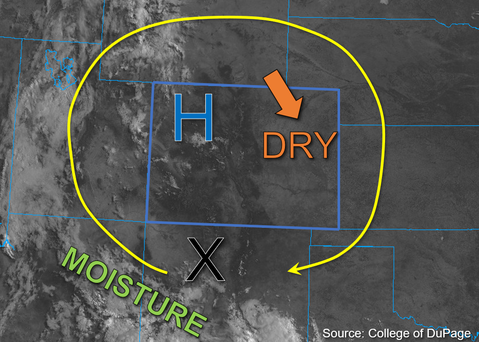
The upper-air pattern is relatively unchanged this morning as compared to yesterday, with the high-pressure system currently located over northwest Colorado. As the High shifts northeastward today, upper-level flow is expected to shift with it and clockwise motion around the High will continue. Dry air continues to advect into eastern Colorado, while moisture over far western Colorado shows a marked increase compared to yesterday. Grand Junction’s morning PW measurement of 1.02 inches reflects this increase, however dewpoint depressions are quite high, indicating more limited surface moisture.
A subtle change in today’s forecast as compared to yesterday is the increase in instability that is forecast for western Colorado, with values between 800-1300 J/kg of CAPE possible. However, given that storms are already beginning to develop over the mountains, earlier rainfall may limit some of these higher CAPE values from being realized. Still, a shortwave disturbance over northern New Mexico, marked by the “X” in the visible satellite image below, should move over southwest Colorado and help drive scattered storm development this afternoon.
Initially, these storms should develop over the higher terrain in southwest Colorado before spreading northwestward over west and northwest Colorado by evening. Given the relatively dry boundary layer, storms today should produce most of their accumulation over the high terrain with an increasing threat for strong outflow winds as they move into the valleys. Additionally, steering speeds up to 20mph and relatively small storm cores should limit the heavy downpours to 30 to 45 minutes, so NO flooding is expected today.
Today’s Flood Threat Map
For more information on today’s flood threat, see the map below. If there is a threat, hover over the threat areas for more details, and click on burn areas to learn more about them. For Zone-Specific forecasts, scroll below the threat map.

Zone-Specific Forecasts:
Southwest Slope, San Juan Mountains, San Luis Valley, Grand Valley, Central Mountains, Northern Mountains, & Northwest Slope:
A few stray high-level clouds are noted across parts of western Colorado this morning. Scattered storm development is already beginning this morning and should increase through the afternoon, beginning over primarily the higher elevations of southwest Colorado and spreading northwest through the afternoon and evening. Several rounds storms are anticipated through the late evening. Isolated max 30-minute rain rates up to 0.8 inches are possible with storm cores that are able to briefly anchor to the higher terrains. In addition to brief rainfall, lightning, strong outflow winds, and small hail may be possible, but flooding is NOT expected today.
Primetime: 1PM to Overnight
Front Range, Urban Corridor, Northeast Plains, Palmer Ridge, Southeast Mountains, Southeast Plains, & Raton Ridge:
Clear skies and dry conditions are expected to continue today for eastern Colorado as dry air continues to move into the area from Wyoming. Precipitation should be confined west of the Continental Divide today. A few isolated storms may develop over the high elevations this afternoon and produce max 1-hour rain rates up to 0.5 inches over the Front Range with limited rainfall chances over the Southeast Mountains. NO flooding is expected today.