Issue Date: Wednesday, August 10th, 2022
Issue Time: 10:15 AM MDT
— Flooding is NOT expected today
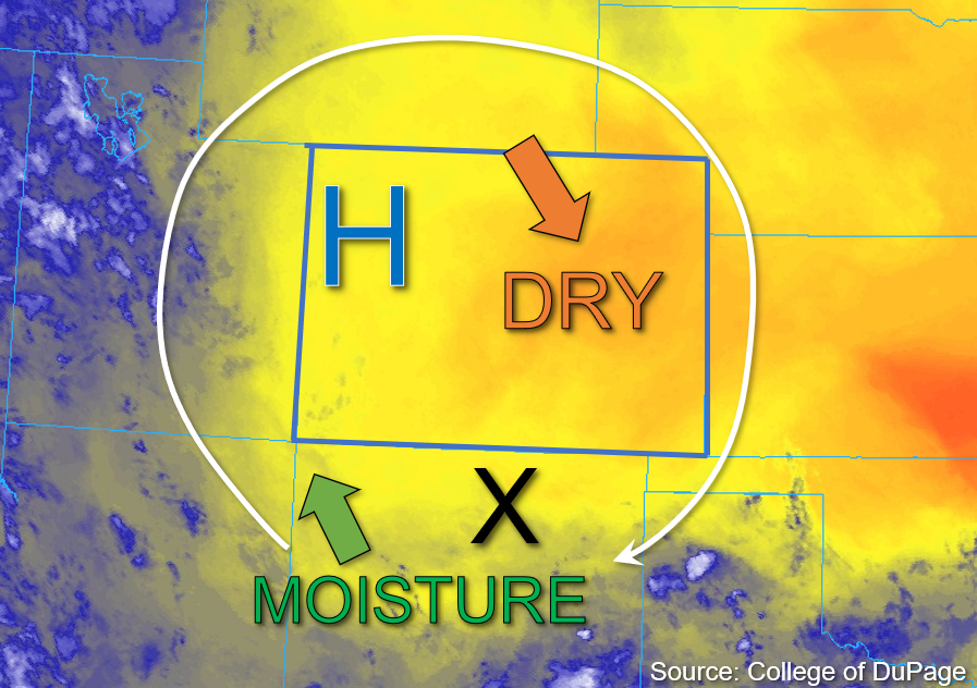
The high-pressure system responsible for the current drying trend in Colorado has shifted slightly north and east from yesterday, as shown in the water vapor image below. As this system continues its northeast track, the deepening High is expected to continue to advect drier air from Wyoming into the eastern half of the state. This is evidenced by Platteville’s measured PW of 0.71 inches this morning, a decrease from yesterday. Meanwhile, the western half of Colorado has seen some increase in moisture relative to yesterday due to monsoonal moisture advection from the south, with Grand Junction measuring a PW value of 0.88 inches this morning.
As the high shifts northeastward, a disturbance in New Mexico, marked by the “X” in the image below, should track across the western part of the state this afternoon and trigger widely scattered storm development this afternoon. Instability should be fairly limited over westerly Colorado, so storms that do form are expected to be of lower intensity and produce only briefly moderate to heavy downpours. A few storms may persist for an hour or two if they are able to anchor to the higher terrain, but rain rates are still expected to remain below flood thresholds, so flooding is NOT expected today.
Today’s Flood Threat Map
For more information on today’s flood threat, see the map below. If there is a threat, hover over the threat areas for more details, and click on burn areas to learn more about them. For Zone-Specific forecasts, scroll below the threat map.

Zone-Specific Forecasts:
Southwest Slope, San Juan Mountains, San Luis Valley, Grand Valley, Central Mountains, Northern Mountains, & Northwest Slope:
Skies are mostly clear aside from some patchy stratus over southwest Colorado, and temperatures are mild to warm. This afternoon, widely scattered storm development is likely over primarily west central and southwest Colorado. These storms could produce isolated heavier rainfall of up to 0.75 inches in one hour over higher terrains of the Southwest Slope and the western San Juan Mountains. These storms will then likely congeal into clusters of lower-intensity storms producing light to moderate rain rates up to 0.5 inches as they track northwest over the Grand Valley and southern Northwest Slope, with a few light showers possible over the western Central Mountains as well. Flooding is NOT expected today.
Primetime: 1PM to Midnight
Front Range, Urban Corridor, Northeast Plains, Palmer Ridge, Southeast Mountains, Southeast Plains, & Raton Ridge:
Skies are mostly clear and temperatures are warm this morning across eastern Colorado. This afternoon, a few isolated to widely scattered storms are possible over the Southeast Mountains and Raton Ridge as upslope flow increases convergence over the higher terrain. Given steering speeds up to 20mph this afternoon, storms that do develop should only have a brief window for producing 30-minute rain rates up to 0.40 inches before moving off into New Mexico. Flooding is NOT expected today.
Primetime: 2PM to 8PM