Issue Date: Sunday, September 8th, 2019
Issue Time: 9:40AM MDT
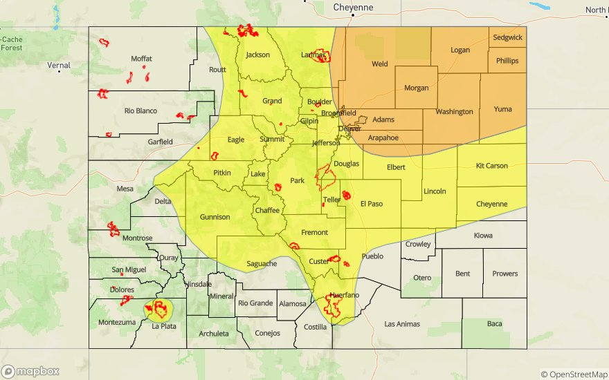
— A MODERATE flood threat has been issued for the Northeast Plains and northern Urban Corridor
— A LOW flood threat has been issued for the Northern Mountains, Central Mountains, northern San Juan Mountains, Front Range and Palmer Ridge
— A LOW flood threat has been issued for the following burn areas: Lake Christine, 416/Burro, Hayden Pass, Spring Creek and Junkins
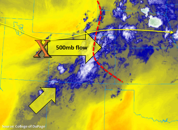
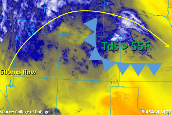
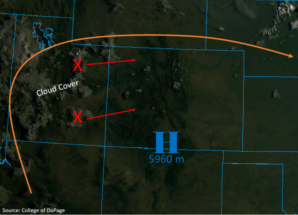
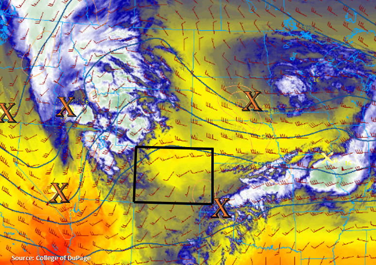
Nearly statewide rainfall is anticipated today as the trough to our west pulls to the northeast and provides moisture and largescale lift for afternoon and evening storms. The negatively tiled trough is currently over Nevada with the base of the trough marked with the orange “X”. Upper level flow will become more southwesterly this afternoon as this feature moves eastward. This pattern will also yield very high PW values (greater than 1.2 inches) over the eastern plains. The Denver sounding is currently at 0.71 inches, but expecting this to increase throughout the day with easterly and southeasterly surface flow. Trailing storms will allow accumulations to increase over the mountains, so the Low threat has been extended to areas where this will be most probable. Extremely dry soils from lack of rainfall may help increase runoff as well. The Low threat over western Colorado also includes the two new newer burn areas: 416 and Lake Christine and a NWS Flood Watch has been issued for these areas as well. Mud flows, debris slides and local stream flash flooding will be possible if storms continually track over these areas.
Over the eastern mountains, higher moisture will be in place along with slightly slower storm speeds, so a Low flood threat has been issued for this and due to the trailing storms/widespread nature of the rainfall this afternoon. Numerous flooding issues are not anticipated, but a few areas with the highest accumulations could experience mud flows, debris slides or flooding of local streams. Not thinking there is flood threat for the Southeast Mountains as drier air moves northward from New Mexico. However, there is still enough moisture and lift to cause concerns that storms will produce rain rates high enough that they could cause flash flooding issues for the Hayden Pass, Junkins, Spring Creek burn areas. Thus, the Low threat has been extended south.
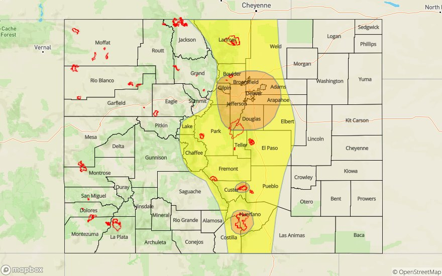
Over the eastern plains, storms are likely over the Southeast Plains (far corner) as they track in from New Mexico, Texas and Oklahoma associated with the disturbance near the “X” above. Not thinking these will cause any flooding issues, but totals near 1 inch will be possible by morning. Highest moisture will be over the Northeast Plains, and as storms move off the mountains this afternoon they will also decrease in speed. Therefore, totals near 2 inches will be possible in the Moderate threat area with a couple storm cores capable of producing around 2.5 inches over the far Northeast Plains. The shortwave will eventually exit the state just after midnight with a couple lingering showers possible over the far southeast corner through early tomorrow morning. A Moderate/Low threat has been issued with Low threats for the burn areas listed above.
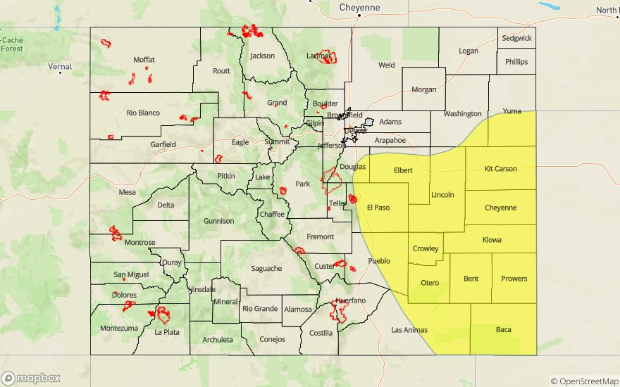
Today’s Flood Threat Map
For more information on today’s flood threat, see the map below. For Zone-Specific forecasts, scroll below the map.

Zone-Specific Forecasts:
Front Range, Southeast Mountains, Central Mountains, Northern Mountains, San Juan Mountains, San Luis Valley:
Trailing thunderstorms and dry soils over these regions may cause flooding issues such as mud flows, debris slides and local stream flash flooding this afternoon. These threats will be exacerbated if storms track over recent burn areas. Storm totals up to 1.25 inch will be possible over the Front Range and Northern Mountains with totals up to 1 inch over the Central Mountains. Max 1-hour rain rates up to 0.75 inches will be possible over the Southeast Mountains. Over the San Juan Mountains, totals up to 0.8 inches will be possible. The San Luis Valley should see rain for the second day in a row! More widespread values of 0.5 inches will be possible with a couple isolated totals up to 0.75 inches. A Low flood threat has been issued, which includes recent burn areas.
Primetime: 12PM to 10:30PM
Urban Corridor, Northeast Plains, Raton Ridge, Palmer Ridge, Southeast Plains:
As thunderstorms exit the mountains and move to the northeast, they will encounter some very high moisture, while also decreasing in pace. Max 1-hour rain rates up to 2 inches will be possible over the Moderate threat area with isolated totals around 2.5 inches over the Northeast Plains. Field ponding, road flooding, local stream flash flooding and flooding of low-lying areas are the main flood threats. Small hail with pockets of severe hail are likely with the stronger storm cores. Flooding remains the main threat, but very strong winds may produce some damage as well with storms gaining a linear component (line of storms) as they move to the northeast. Over the Southeast Plains (southeast corner), totals up to 1 inch are possible by morning for the continuous rainfall. For the Raton Ridge and Palmer Ridge, storm totals between 0.75 and 0.9 inches will be possible. A Moderate threat has been issued with a Low threat for the Junkins, Hayden Pass and Spring Creek burn areas.
Primetime: 3PM to 1AM
Northwest Slope, Grand Valley, Southwest Slope:
Rainfall will be on the earlier end of the forecast with the trough quickly approaching. With widespread storms forecast, rainfall will be likely over the valleys as they track off the higher terrains or in from Utah. Max 1-hour rain rates up to 0.75 inches will be possible over the Northwest Slope with rates dropping to 0.5 inches over the Grand Valley. Not as much moisture is over the Southwest Slopes, but totals up to 0.25 inches (higher terrains) will be possible with 0.15 inches possible over the lower elevations. Flooding is not forecast.
Primetime: 10AM to 8PM