Issue Date: Friday, September 6th, 2019
Issue Time: 8:40AM MDT
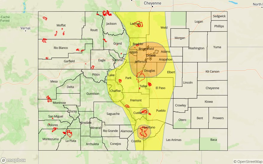
— A MODERATE flood threat has been issued for the Front Range, Urban Corridor, Junkins and the Spring Creek burn areas
— A LOW flood threat has been issued for the Southeast Mountains, Central Mountains, and eastern portions of the Palmer Ridge, Raton Ridge and Southeast Plains. This threat includes the Hayden Pass burn area.
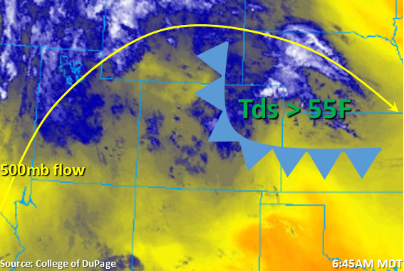
Marked in the water vapor imagery below is the aforementioned cold front from yesterday’s FTO. This feature is currently pushing south and returning lots of moisture to the atmosphere behind it. This low level moisture return is presenting itself with high dew points, heavy cloud cover and a few light showers over the Northeast Plains, Urban Corridor and Palmer Ridge. PW was a whopping 1.06 inches in the Denver sounding this morning! As the cold front pushes south it looks to stall out somewhere south of the Palmer Ridge. Post frontal upslope flow behind the front and slow storm motion will set the stage for the heavy rainfall threat this afternoon. As the next approaching trough to our west moves eastward, upper flow is forecast to turn more westerly. This will allow storms to spill into the adjacent plains this afternoon and evening with another round of lighter rainfall possible overnight with continuous upslope flow in a moisture rich environment.
As the widespread showers and weak thunderstorms kick off over the higher terrains during the early afternoon, storm movement will be to the west at 10 mph. Trailing storms may allow for higher accumulations, thus the Low flood threat for the eastern mountains. With nearly stationary/slow moving storms, a Moderate flood threat has been issued for the Spring Creek and Junkins burn areas. The Low flood threat should suffice for the Hayden Pass burn area as the better moisture will be to the west of the scar. Storms may pick up in intensity as they slide off the foothills, so a couple severe thunderstorms may be possible along the I-25 corridor this afternoon and early evening. Heavy rainfall is possible over the Urban Corridor, so a Moderate flood threat has been issued for the Denver Metro area. Storms are anticipated to weaken as the move east due to a cap and decreasing instability, so expect storms to start to disband just east of Highway 71/104°W. A Moderate/Low flood threat has been issued for Friday. For rain rates, please see the zone-specific discussions below.
Today’s Flood Threat Map
For more information on today’s flood threat, see the map below. For Zone-Specific forecasts, scroll below the map.

Zone-Specific Forecasts:
Front Range, Central Mountains, Southeast Mountains, Raton Ridge, Urban Corridor, Northeast Plains, Palmer Ridge, Southeast Plains:
Widespread showers and thunderstorms are forecast for this afternoon. Over the mountains, storms will be capable of producing max 1-2 hour rain totals up to 1.40 inches (over the Moderate threat area) and 1.25 inches (south). With slower storm motion, a Moderate flood threat has been issued for the Junkins and Spring Creek burn areas, with the Hayden Pass burn area under the Low threat. Threats this afternoon include flash flooding of local streams/creeks, mud flows and debris slides. Those threats are more likely over burn areas if a storm tracks overhead.
A couple severe thunderstorms may be possible as the storms move into the adjacent plains. Threats from the severe storms include severe hail (1-1.25 inch diameter), gusty winds and heavy, local rainfall. Max 1-hour rain rates up to 1.5 inches will be possible with some isolated, slightly higher storm totals. Thus, the heavy rainfall threats include field ponding, flooding of local streams/creeks, road flooding and flooding of low-lying areas. A Moderate flood threat has been issued for the Denver Metro area. Another round of light showers and weak thunderstorms is possible overnight with the continuous upslope flow.
Primetime: 1PM to 2AM
Northwest Slope, Grand Valley, Southwest Slope, Northern Mountains, San Juan Mountains, San Luis Valley:
Unfortunately, the moisture return isn’t quite as strong west of the Continental Divide, but there should be an uptick in storm coverage this afternoon over the high terrains. Expecting another round of scattered, afternoon/evening showers and weak thunderstorms to kick off during the afternoon. Highest accumulations will again be near the Divide and over the San Juan Mountains with up to 0.75 inches possible in the stronger storm cores. A shortwave moves over the southwest corner early tomorrow morning, which may help spark another round of weak showers over the San Juan and Central Mountains. Accumulations up to 0.25 inches may be possible with these storms. Flooding is not forecast.
Primetime: 1PM to 9AM