Issue Date: Thursday, September 5th, 2019
Issue Time: 10:50AM MDT
–Flooding is NOT expected today
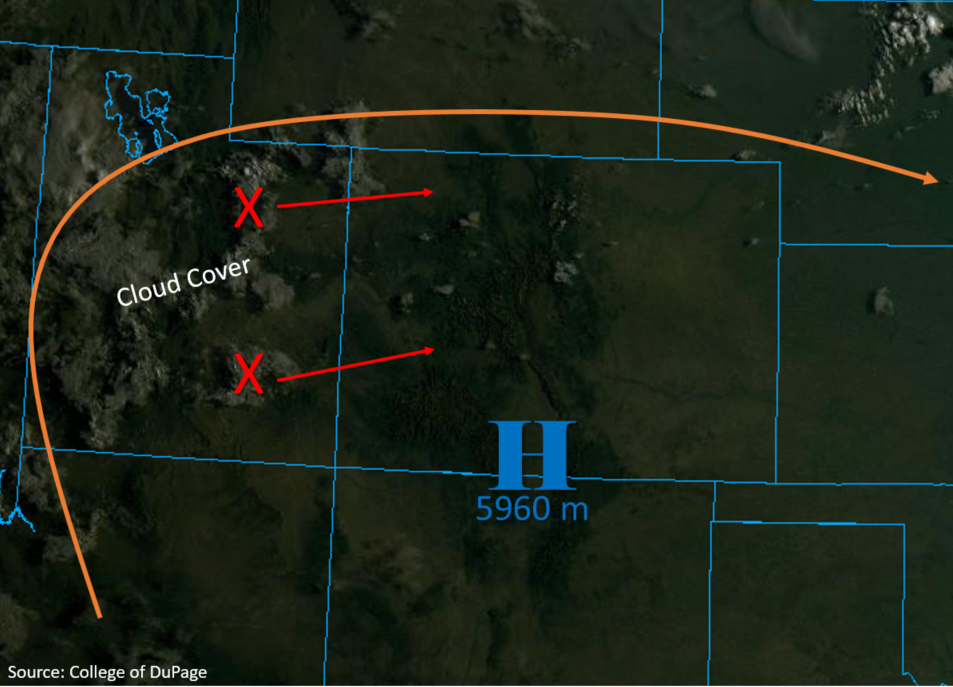
The high pressure ridge remains overhead once again today and has increased in strength slightly with the center of the high now measuring a height of 5,960m (5940m yesterday at this time). This means that the strength of the subsidence (sinking motion) will be stronger today, which has resulted in the mostly clear skies shown in the visible satellite imagery below. Cloud cover and storm potential will increase over western Colorado throughout the day as two weak shortwaves (marked with X below) and mid-level moisture move in from Utah. Downsloping winds this morning will mix out the surface moisture, so storms are expected to be high based once again today with the main threats being light to moderate rainfall, lightning and brief wind. Storm coverage will favor the Northern, Central and Front Range Mountains where subsidence underneath the high pressure center is less severe. Storm motion is expected to be fairly slow under the ridge and continuous storm generation over the mountains is likely. Therefore, as the rainfall continues, the atmosphere will be more conductive for higher rainfall rates later in the day. Isolated storm totals up to 0.9 inches are possible.
To the east clear skies, down sloping winds and a building ridge will allow high temperatures to increase by another 3°F to 5°F from yesterday’s values. This wind pattern will also drop dew points to the 30°Fs and low 40°F by mid-afternoon over the eastern plains. So as storms move off the high terrains into the Urban Corridors and Palmer Ridge, rain rates will be less efficient. As they move west of Highway 71 (104°W) the area looks to remain capped, so storms may produce some gusty winds as they dissipate in similar fashion to yesterday. Flooding is not expected from storms today, but rather looking at a nice wetting rainfall for the high terrains.
Today’s Flood Threat Map
For more information on today’s flood threat, see the map below. For Zone-Specific forecasts, scroll below the map.

Zone-Specific Forecasts:
Northwest Slope, Northern Mountains, Front Range, Grand Valley, Central Mountains, Southwest Slope, San Juan Mountains:
Storms are expected throughout the region this afternoon and into tonight. Coverage will favor the Front Range and Central/Northern Mountains, especially along the Continental Divide. Expecting isolated storm totals up to 0.90 inches near the Continental Divide with most of the mountains having storm totals closer to 0.50 inches. Storms are expected to be high based once again, so brief, isolated gusts up to 40 mph may be possible with the stronger storms. Coverage will begin around noon and extend until 10 PM tonight with a few later storms forecast over the Northwest Slope and Grand Valley. Totals between 0.1 and 0.25 inches may be possible by tomorrow morning over the lower elevations with up to 0.5 inches along the Flat Tops. Flooding is not forecast today.
Primetime: 12PM to Midnight
San Luis Valley, Southeast Mountains, Southeast Plains, Palmer Ridge, Urban Corridor, Northeast Plains, Raton Ridge:
Expecting high temperatures to increase by 3°F to 5°F over the area with highs reaching into the triple digits over the Northeast and Southeast Plains under the building ridge. Thunderstorms are possible over the Urban Corridor, Palmer Ridge and Southeast Mountains, but dry air will keep the storms high-based with light accumulations once again. Isolated storm totals up to 0.6 inches are forecast over these areas favoring the Palmer Ridge once again for the highest accumulations due to extra convergence. Elsewhere over the lower elevations, max 1-hour rainfall rates will drop to 0.25 inches. Threats today include brief, wind gusts up to 40 mph and lightning. Flooding is not expected.
Primetime: 2PM to 11PM