Issue Date: Saturday, September 7th, 2019
Issue Time: 9:50AM MDT
— A LOW flood threat has been issued for the Palmer Ridge, Raton Ridge, Southeast Plains and southern Northeast Plains
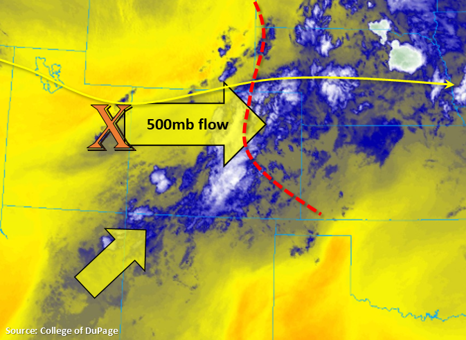
Quite the southwest to northeast disturbance in the water vapor imagery below. This is producing a lot cloud cover, scattered fog over the Northern Mountains and light showers over the San Juan Mountains. The visible satellite imagery (not shown) shows some more convective storms over the Northeast Plains, so some light showers are likely occurring with the right entrance of the jet overhead. As the trough slides west today, flow aloft will turn from southwesterly to westerly. This will pull in the disturbance from Utah (marked with an “X” below) to help spark more numerous showers and weak thunderstorms over the San Juan and Central Mountains this afternoon. This will also allow for some storms to survive over the San Luis Valley, which very much needs the rainfall. Also marked in the image below is a stationary front (red dashed line), which is yesterday’s cold front. This is helping keep moisture high over the region, but westerly flow aloft should mix the best moisture into Kansas and Nebraska (dew points over 60°F). The Northeast Plains looks to mostly remain capped this afternoon with slightly cooler temperatures forecast. There is a small potential for an isolated storm near the Kansas border tonight, and with high moisture returning and nearly stationary storms on a boundary, the Low flood threat has been extended north for this isolated incident.
Storms this afternoon will favor the southern high terrains with the highest rainfall accumulations over western Colorado occurring in the eastern San Juans and along the Divide (south). Not thinking there will be enough moisture for Southeast Mountain burn areas to reach flooding thresholds, plus swifter storm motion should also keep totals low. Of course, caution should always be used any time a storm passes over a recent scar. Over the eastern mountains, westerly flow aloft should push the storms into the adjacent plains by early afternoon where they will initially favor the higher terrains of the Palmer and Raton Ridge. As storms move eastward, outflow boundaries and slightly more southerly steering flows will likely produce storms over the Southeast Plains. Steering flows are anticipated to decrease throughout the day/eastward, and with several boundaries in the area (extra convergence) and mid-level energy moving through the flow, a Low flood threat has been issued. While widespread, heavy rainfall is not forecast, a couple storms could produce totals above flood threat thresholds if they back build/remain stationary.
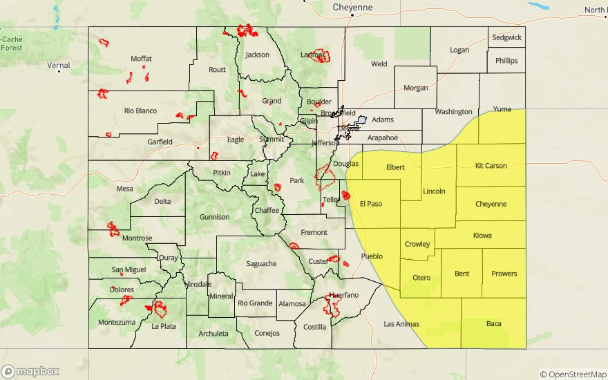
Today’s Flood Threat Map
For more information on today’s flood threat, see the map below. For Zone-Specific forecasts, scroll below the map.

Zone-Specific Forecasts:
Front Range, Southeast Mountains, Raton Ridge, Urban Corridor, Northeast Plains, Palmer Ridge, Southeast Plains:
Max 1-hour rain rates up to 0.50 inches are possible over the southern Front Range and immediate adjacent plains. Rates drop to 0.15 inches over the Southeast Mountains due to lack of low level moisture. Over the Palmer Ridge, max 1-hour rain rates up to 1 inch are possible with that increasing to 1.25 inches over the far eastern plains/eastern Raton Ridge. Should a storm linger over an area or on a boundary, storm totals up to 1.75 to 2 inches may be possible. Thus, a Low flood threat has been issued. Threats include flooding of roads, low-lying areas, field ponding, flash flooding of local streams/creeks and arroyo flooding. A couple storms may be marginally severe this afternoon with the main threat being strong winds and lightning, although marginally severe hail may also be possible, too.
Primetime: 12PM to Midnight
Northwest Slope, Grand Valley, Southwest Slope, Northern Mountains, San Juan Mountains, San Luis Valley, Central Mountains:
Storms should start to form fairly early today with the passing shortwave helping kick off activity. Max 1-hour rain rates up to 0.70 inches will be possible over the San Juan Mountains with isolated totals up to 1 inches possible by tomorrow morning (eastern San Juans). 1-hour rain rates decrease to 0.25 inches over the Central Mountains and to 0.15 inches over the Northern Mountains. Looks like the San Luis Valley will also get some much needed rainfall as well. Accumulations up to 0.50 inches possible over the northern and eastern regions of the valley. The shortwave moves out fairly quickly this afternoon and with westerly flow pulling in a drier air mass, storms should end by early evening. A couple morning showers are possible again over the San Juan Mountains as the next shortwave moves overhead, but flooding is not forecast.
Primetime: 12PM to 7PM