Issue Date: Sunday, August 21st, 2022
Issue Time: 11:00AM MDT
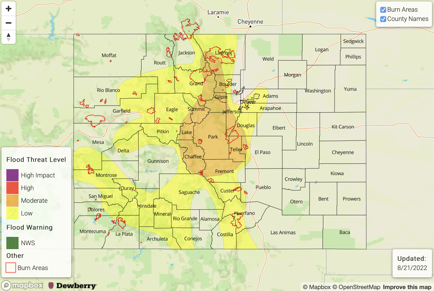
— A MODERATE flood threat has been issued for the Central Mountains, Northern Mountains, & Front Range
— A LOW flood threat has been issued for the Urban Corridor, Northwest Slope, Grand Valley, San Juan Mountains, Southwest Slope, & Southeast Mountains
— Fire-Burn Forecast Summary: 3 burn areas under HIGH threat, 4 burn areas under MODERATE threat, 3 burn areas under LOW threat; click HERE for more info
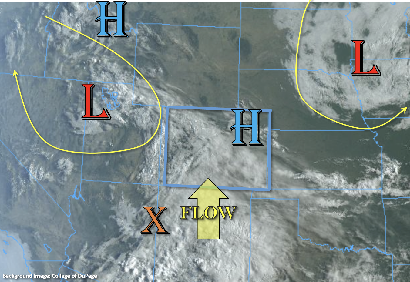
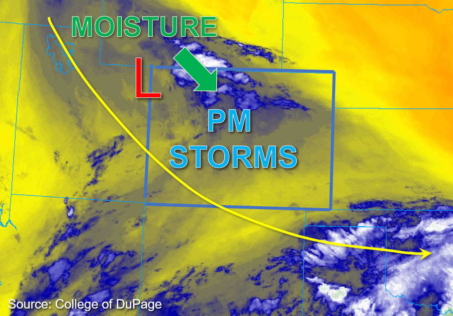
A few widely scattered rain showers are ongoing this morning across portions of northwestern Colorado in association with the upper trough centered over far northeast Utah. As the low moves southeast through Colorado today, moisture advection and mid-level lift will accompany it. This morning, Grand Junction measured a PW value of 1.03 inches, and Platteville measured a similar PW value of 1 inch, indicating plentiful column moisture. Surface dewpoints ranging from the mid-40s to mid-50s°F indicate sufficient moisture through the boundary layer for storms to utilize this afternoon.
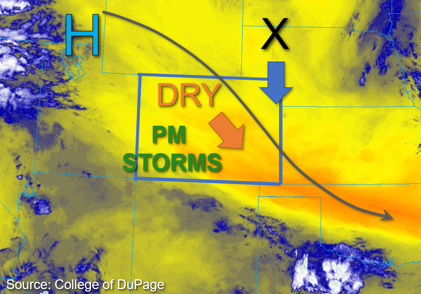
That said, cloud cover and the early rain showers are expected to keep instability fairly limited across the northern portions of the state. Greater clearing further south should allow instability to reach forecast values between 1000-1500 across central Colorado this afternoon. Additionally, the midlevel energy from the deepening Low is forecast to reach central Colorado by early afternoon, by which point numerous rain showers are anticipated to overspread much of the higher elevations west of the Continental Divide. A few of these storms may spill onto the adjacent foothills and Urban Corridor. Upper-level steering flow is anticipated to be quite slow, perhaps only 5 to 10mph, so storms that form are expected to be slow-moving and thus produce a couple to several hours of rainfall.
The greatest concern for heavy rainfall and flooding potential exists over the higher elevations of central and western Colorado where storms are more likely to anchor to the higher terrain given the slow steering speeds. As mentioned, a few storms may drift onto the adjacent foothills and produce isolated, locally heavy rainfall as well. A MODERATE flood threat has been issued for portions of central and northern Colorado, and a LOW flood threat for mainly mountainous areas south and west.
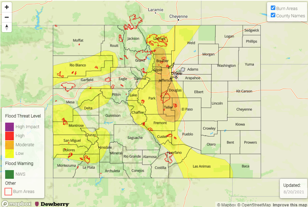
Today’s Flood Threat Map
For more information on today’s flood threat, see the map below. If there is a threat, hover over the threat areas for more details, and click on burn areas to learn more about them. For Zone-Specific forecasts, scroll below the threat map.
Zone-Specific Forecasts:
Northwest Slope, Northern Mountains, Front Range, Urban Corridor, Central Mountains, Grand Valley, Southwest Slope, San Juan Mountains, San Luis Valley, & Southeast Mountains:
Widely scattered rain showers across parts of western Colorado this morning are forecast to increase in coverage this afternoon across mainly the higher elevations, with some spillover into the adjacent lower elevations. Max 1-hour rain rates up to 1.75 inches and 3-hour rain rates up to 2.75 inches over the Front Range, Central Mountains, and Northern Mountains could cause urban and small stream flooding and field ponding in lower elevations with poor drainage, as well as excessive runoff, debris slides, and mud flows over steep terrain. A MODERATE flood threat has been issued for these forecast zones. Several hours of rainfall can be expected, although the greatest threat should be with the initial, more convective rainfall. Afterwards, lighter rain rates associated with more stratiform precipitation is anticipated.
Meanwhile for portions of southern and western Colorado, max 1-hour rain rates up to 1.25 inches and 3-hour rain rates up to 2.5 inches could cause minor urban and small stream flooding, along with excessive runoff, debris slides, and mud flows over steep terrain. A LOW flood threat has been issued for portions of the Southeast Mountains, San Juan Mountains, Southwest Slope, Grand Valley, and Northwest Slope, as well as extending into parts of the Urban Corridor.
Primetime: Ongoing to Midnight
Northeast Plains, Palmer Ridge, Raton Ridge, & Southeast Plains:
Mainly clear skies are noted across eastern Colorado this morning, while slightly below average temperatures are forecast. Most storms and associated heavy rainfall are expected to remain confined to the higher elevations and adjacent foothills west. A stray storm or two may drift into the eastern plains this afternoon and produce brief, isolated 30-minute rain rates up to 0.4 inches, along with gusty winds. NO flooding is expected for the Palmer Ridge or eastern Plains today. Over the western Raton Ridge, max 1-hour rain rates up to 1.25 inches and 3-hour rain rates up to 2.5 inches are possible, and a LOW flood threat has been extended into the western portion of this zone.
Primetime: 3PM to Midnight