Issue Date: Saturday, August 20th, 2022
Issue Time: 9:55AM MDT
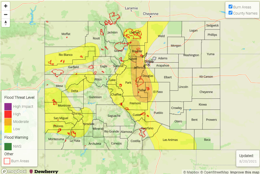
— A MODERATE flood threat has been issued for the Front Range
— A LOW flood threat has been issued for the Northwest Slope, Grand Valley, Southwest Slope, San Juan Mountains, Central Mountains, Southeast Mountains, Raton Ridge, Southeast Plains and Urban Corridor
— Fire-Burn Forecast Summary: 6 burn areas under MODERATE threat; 2 burn areas under LOW threat; click HERE for more info
Monsoon moisture and mid-level energy are over the state this morning helping to create lots of cloud cover and some light to moderate rainfall. The Low over Utah and High over northeast Colorado are combining to create southerly flow, which will continue to pull in more moisture and mid-level energy across the southern border today. A new batch of storms are expected to arrive to the southern border by late morning, and some intensification over the Southeast Plains is anticipated this afternoon. Additional storms are forecast to develop over the northern and central mountain areas. Steering flows look to gain more of a westerly component by late this afternoon as the ridge builds northwards, which should help push some of the storms into the immediate adjacent plains. Not much change is anticipated in the speed of the storms, so some longer duration rainfall will be likely again with coverage expanding to areas along and near the Continental Divide.
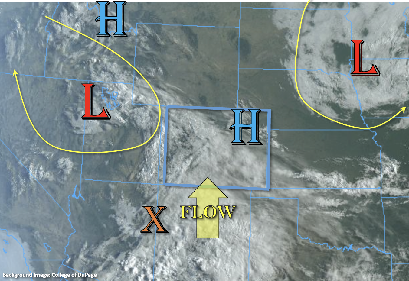
As expected, moisture throughout the atmosphere has increased both east and west with PW at Grand Junction and Platteville measured at 1.03 inches and 0.93 inches, respectively. So, there should be plenty for scattered to numerous storms to develop with increasing upslope flow and some additional lift from mid-level energy. With the ongoing cloud cover, showers and cooler temperatures, instability may be limited today, especially south, which would promote more stratiform instead of convective rainfall. However, pockets of 600-1000 J/kg are still likely to materialize over central and northern Colorado, which will keep the flood threat going today. Similar to yesterday, the initial convective rainfall is expected to pose a flood threat along with longer duration rainfall over a 2-to-3-hour period. A MODERATE and LOW flood threat has been issued.
Today’s Flood Threat Map
For more information on today’s flood threat, see the map below. If there is a threat, hover over the threat areas for more details, and click on burn areas to learn more about them. For Zone-Specific forecasts, scroll below the threat map.
Zone-Specific Forecasts:
Front Range, Central Mountains, Urban Corridor, Palmer Ridge & Northeast Plains:
Initial scattered convection and then more numerous storms with moderate rain rates are anticipated today for the mountains. Max 1-hour rain rates up to 1.5 inches and 3-hour rain rates up to 2.75 inches will be possible. A MODERATE flood threat has been issued. The flood threat should primarily be in the first 1 to 2 hours of storm develop with temperatures expected to drop quickly and produce more stratiform rainfall thereafter. Some spillover into the immediate adjacent plains is forecast this evening with the LOW flood threat extending slightly east into the elevated ridges where max 1-hour rain rates up to 1.75 inches will be possible. Flood threats today include ponding in low-lying areas, road flooding and debris slides/mud flows over steeper terrain. The flood threat should end later this evening with some storms lingering into the overnight hours for the mountains.
Primetime: 12:30PM to 2AM
Southeast Mountains, Raton Ridge, Southeast Plains, San Juan Mountains, Southwest Slope, San Luis Valley, Northwest Slope, Northern Mountains & Grand Valley:
Scattered storms are forecast north today with more numerous storms forecast south. Max 30-minute rain rates up to 1 inch (north) and 1-hour rain rates up to 1.5 inches (south) are forecast. Some longer duration rainfall is again anticipated for the San Juan Mountains and nearby elevated regions with storm totals up to 2.25 inches possible. A LOW flood threat has been issued, and if more intense storms track over the same areas as yesterday, an increase in runoff is expected. Rainfall will likely linger over the mountains tonight with the flood threat ending this evening.
Primetime: 12PM to 4AM