Issue Date: Friday, August 19th, 2022
Issue Time: 10:40AM MDT
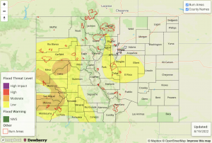
— A MODERATE flood threat has been issued for the Grand Valley, Southwest Slope and portions of the western San Juan Mountains
— A LOW flood threat has been issued for the Northwest Slope, Central Mountains, Northern Mountains, Front Range, Urban Corridor, Palmer Ridge
— Fire-Burn Forecast Summary: 2 burn area under MODERATE threat; 5 burn areas under LOW threat; click HERE for more info
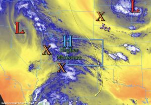
There will be another shift in the synoptic pattern today as the elongated High begins to break up as a Low and associated shortwaves move over the state from the west. In addition to the Low from the west, a Low northeast of Colorado is expected to drop a shortwave and jet into the far eastern plains later this evening, which may allow rainfall to linger over the eastern plains tonight. Both features will help to increase rainfall chances east and west today with storms forecast to become scattered to numerous by late this afternoon.
Over western Colorado, an increase in moisture can be seen by the shades of blue and white in the water vapor imagery above. Lift out in front of the shortwaves (orange “X’s”) has already started to produce moderate showers over the Grand Valley and Southwest Slope. PW at Grand Junction was measured at 0.85 inches with a dew point around 40°F. As the day goes on, rainfall and increasing moisture will likely help to moisten the boundary layer and produce higher rainfall efficiency both over the valleys and high terrain. Slow steering flows should also contribute to higher rainfall accumulations over the high terrain. So, initial convection is expected to pose a flood threat along with longer duration rainfall over a 2-to-3-hour period. A Moderate flood threat has been issued with the potential for road flooding, ponding in low-lying areas and mud flows/debris slides over steeper terrain.
Surface moisture is also on the rise over portions of the eastern mountains, and PW at Platteville was measured at 0.67 inches, showing an increasing trend from yesterday. Upslope flow and moisture advection should take over by this afternoon favoring the northern and central high terrain for scattered storm development. Northwest steering flow is expected to push the storms into the adjacent plains with storms most likely to survive over the elevated ridges. Generally, the lack of surface moisture should limit the flood threat, but isolated heavy rainfall may be possible over the Front Range near the Continental Divide and along the elevated Palmer Ridge where extra convergence my occur. A LOW flood threat has been issued.
Today’s Flood Threat Map
For more information on today’s flood threat, see the map below. If there is a threat, hover over the threat areas for more details, and click on burn areas to learn more about them. For Zone-Specific forecasts, scroll below the threat map.
Zone-Specific Forecasts:
San Juan Mountains, Southwest Slope, Central Mountains, San Luis Valley, Northwest Slope, Northern Mountains & Grand Valley:
Scattered to numerous storms are forecast this afternoon through this evening. Max 1-hour rain rates up to 1.5 inches and 2-to-3-hour storm totals up to 2.25 inches will be possible. With the drier surface layer north/central and higher-end DCAPE values, the more intense thunderstorms that develop could produce some strong outflow winds as well. A MODERATE flood threat has been issued. Flood threats include road flooding, ponding of low-lying areas, rises on local streams/creeks and mud flows/debris slides over steeper terrain. Lighter rainfall will likely linger overnight with a second round of scattered showers beginning tomorrow morning.
Primetime: 11AM to Ongoing
Southeast Mountains, Front Range, Urban Corridor, Palmer Ridge, Northeast Plains, Raton Ridge & Southeast Plains:
Scattered storms return to the eastern mountains today with best coverage forecast along the Front Range. An isolated storm may produce 30-minute rain rates up to 1 inch, which could cause road flooding, mud flows or debris slides under its core. Over the Southeast Mountains, 30-minute rain rates up to 0.4 inches will be possible. As storms move off into the adjacent plains, strong outflow winds are anticipated with rainfall totals generally under 0.5 inches. Slower steering flow, extra convergence over the Palmer Ridge, and moisture advection this afternoon may allow a storm or two to produce 1-hour rain rates up to 1.5 inches this evening. For these reasons, a LOW flood threat has been issued. Some lighter rainfall may linger overnight with a second wave of precipitation possible before tomorrow’s FTB is produced.
Primetime: 12:30PM to Ongoing

