Issue Date: Thursday, August 20th, 2020
Issue Time: 10:50AM MDT
Summary:
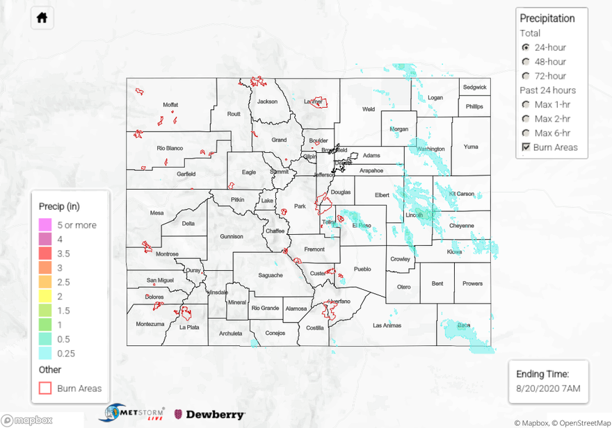
Numerous thunderstorms rolled through the plains of eastern Colorado yesterday, bringing beneficial rainfall to many locations. El Paso County picked up between 0.5 and 1.0 inch of rain from a couple rounds of storms according to CoCoRaHS and Weather Underground stations northeast of Colorado Springs. The highest gauge total was 0.96 inches from a Weather Underground station, with the next highest gauges reporting 0.8 and 0.7 inches. No flooding was reported with these storms.
Up to 0.87 inches of rain fell within 30 minutes in Limon according to a CoCoRaHS observer. Radar indicates a single severe thunderstorm moved through this area between 6:30PM and 7:00PM, which also produced strong outflow winds up to 64 mph according to local storm reports. Higher rain totals near or just over 1 inch are indicated on the QPE as this storm tracked southeast through Lincoln County. The closest rain gauge in Hugo reported 0.41 inches (CoCoRaHS), which is on the northern edge of the storm core, suggesting the higher QPE totals are probable. No flooding was reported with this storm either.
Surprisingly high rain totals were reported in Kit Carson County. A CoCoRaHS observer in Stratton reported 0.65 inches of 24-hour rainfall, and another observer northeast of Burlington reported 0.79 inches. The QPE map does not pick up these higher rain totals over Kit Carson County, likely due to the Denver and Goodland radars being down yesterday. No flooding was reported in Kit Carson County as of this morning.
Storms over the mountains were unable to produce significant rainfall, but wind gusts were reported up to 52 mph from these storms. CoCoRaHS reports across the mountainous regions this morning indicate under 0.1 inches of rain fell from storms yesterday. The strong wind reports were from near Rifle and Aspen. Unfortunately these gusty outflow winds allowed the Williams Fork wildfire to grow rapidly yesterday afternoon. See a summary of current wildfire sizes and containment below.
Wildfire Update:
Pine Gulch – north of Grand Junction: 121,781 acres; 14% contained (still 2nd largest CO wildfire)
Grizzly Creek – Glenwood Canyon: 29,732 acres; 4% contained
Cameron Peak – Medicine Bow Mountains: 16,461 acres; 0% contained
Williams Fork – Arapaho National Forest: 9,457 acres; 3% contained (grew 2,731 acres due to strong winds from thunderstorms)
For rainfall estimates in your area over the last 24, 48, and 72 hours, check out our State Precipitation Map below.
Click Here For Map Overview