SPM 05-31-2021: Widespread Rain Along Front Range and Eastern Plains

Issue Date: Monday, May 31, 2021
Issue Time: 10:15 am MDT

Summary

Yesterday saw widespread, long-duration rain across the eastern half of Colorado – nearly all of it received at least 0.5 inches of rain, as seen in the 24-hour State Precipitation Map at the bottom of this post. Locally, even heavier totals were reported by CoCoRaHs observers which may not yet be reflected in the SPM. The top 5 reports for the state are seen in the table below, as well as estimated Average Recurrence Interval (ARI) from NOAA Atlas 14.

Even though it rained for most of the day yesterday, rainfall rates were relatively low despite available moisture, this was due to cooler temperatures and increased cloud cover preventing enhanced convection. This resulted in the low ARIs observed.

Despite the wet day, flooding was not reported on Sunday and all gauges in the state remain below flood stage. That is not to say that rivers are not running high. Gauges along the Arkansas River in Southeast Colorado, including its tributary the Purgatoire River, remain greater than 95% of normal streamflow for this time of year. In Northern Colorado the Cache la Poudre, Big Thompson, St. Vrain, Boulder Creek, and Cherry Creek are all also above 95% of normal streamflow too.

Click Here For Map Overview

The map below shows radar-estimated, rainfall gage-adjusted Quantitative Precipitation Estimates (QPE) across Colorado. The map is updated daily during the operational season (May 1 – Sep 30) by 11AM. The following six layers are currently available: 24-hour, 48-hour and 72-hour total precipitation, as well as maximum 1-hour, 2-hour and 6-hour precipitation over the past 24 hour period (to estimate where flash flooding may have occurred). The accumulation ending time is 7AM of the date shown in the bottom right corner. Also shown optionally are vulnerable fire burn areas (post 2012), which are updated throughout the season to include new, vulnerable burn areas. The home button in the top left corner resets the map to the original zoom.

SPM 05-30-2021: Heavy Rain, Flooding Along Arkansas River in Southeast Colorado

Issue Date: Sunday, May 30, 2021
Issue Time: 10:00 am MDT

Summary

Saturday was an active day for severe thunderstorms up and down the Eastern Plains, the Front Range Mountains, Palmer Ridge, and Raton Ridge. Storms began to form over the higher elevations in the early afternoon and made their way eastward, producing very heavy rain and large hail. For rainfall estimates in your area, check out our State Precipitation Map the bottom of this post.

Flash flood and flood warnings were issued for several storm cells that produced heavy rain, including for the Cameron Peak burn scar in Larimer County and the Junkins burn scar in Custer County. No flooding was reported over these burn scars yesterday.

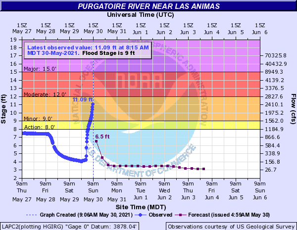
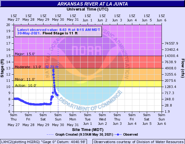
However, heavy precipitation continued well into the night last night, resulting in the Purgatoire River near Las Animas to reach minor flood stage (seen in the first hydrograph below). Additional flood reports from upstream near La Junta in the very early hours of the morning include high water flowing across State Highway 109, several homes flooded, and arroyos draining into the Arkansas River causing that river to also reach minor flood stage overnight, eventually cresting at 12.73 feet before coming back down below flood levels (second hydrograph below).

Click Here For Map Overview

The map below shows radar-estimated, rainfall gage-adjusted Quantitative Precipitation Estimates (QPE) across Colorado. The map is updated daily during the operational season (May 1 – Sep 30) by 11AM. The following six layers are currently available: 24-hour, 48-hour and 72-hour total precipitation, as well as maximum 1-hour, 2-hour and 6-hour precipitation over the past 24 hour period (to estimate where flash flooding may have occurred). The accumulation ending time is 7AM of the date shown in the bottom right corner. Also shown optionally are vulnerable fire burn areas (post 2012), which are updated throughout the season to include new, vulnerable burn areas. The home button in the top left corner resets the map to the original zoom.

Note: The 24-hour, 48-hour and 72-hour total precipitation do not contain bias corrections today due to errors in the CoCoRaHS data. This means there may be underestimations in QPE over the southwest and southeast corners of the state.

SPM 05-29-2021: Isolated Severe Storms Over Raton Ridge, Otherwise Warm and Pleasant Friday For Most

Issue Date: Saturday, May 29, 2021
Issue Time: 10:15 am MDT

Summary

With a transient ridge overhead, sunshine was aplenty for most of Colorado on Friday, along with slightly above normal temperatures. However, in typical Colorado fashion, our unique summer circulation (that is driven strongly by heating over the higher terrain) was able to generate isolated thunderstorms, a few that were severe, over the Raton Ridge, Palmer Ridge and parts of the Northeast Plains.

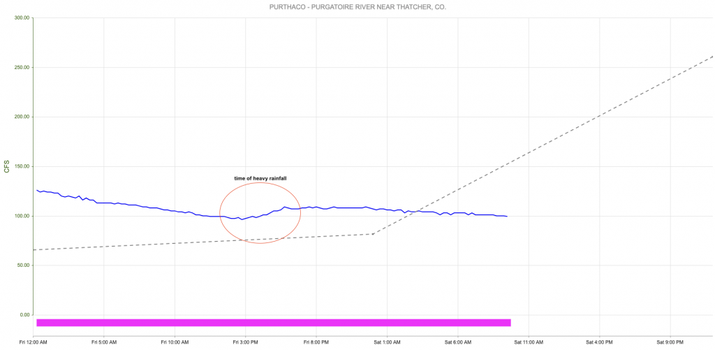
By far the most impressive storms were located over the Raton Ridge, and trekked once again over the Purgatoire River basin. This region is one of the most poorly observed areas of the state, which manifested itself in a huge discrepancy in estimate rainfall rates. Both Stage IV and MRMS guidance estimated that over 2 inches of rainfall occurred in the small Trinchera Creek tributary of the Purgatoire. However, the MetStorm product shown below estimates less than 0.5 inches fell in the 24-hour period (it also estimates max 1-hour intensity of 0.5-1.0 inch; it is common for the 1-hour estimate to be higher than the 24-hour in these situations since the 1-hour is strongly biased towards the more uncertain radar-only estimates). Perhaps the verdict lies in the streamflow. A USGS gage located on the Purgatoire River just downstream of the confluence with Trinchera Creek noted only a ~15 c.f.s. rise in streamflow, shown below. Keep in mind this is the same gauge that rose above 5,000 c.f.s. with the recent rain. With this limited increase in flow yesterday, it is very hard to imagine that anywhere near 2.0 inches of rain actually fell. The most likely outcome was hail contamination causing a spike in the radar estimated rainfall, with actual rainfall likely in the 0.5-1.0 inch range possible.


Click Here For Map Overview

The map below shows radar-estimated, rainfall gage-adjusted Quantitative Precipitation Estimates (QPE) across Colorado. The map is updated daily during the operational season (May 1 – Sep 30) by 11AM. The following six layers are currently available: 24-hour, 48-hour and 72-hour total precipitation, as well as maximum 1-hour, 2-hour and 6-hour precipitation over the past 24 hour period (to estimate where flash flooding may have occurred). The accumulation ending time is 7AM of the date shown in the bottom right corner. Also shown optionally are vulnerable fire burn areas (post 2012), which are updated throughout the season to include new, vulnerable burn areas. The home button in the top left corner resets the map to the original zoom.

Note: The 24-hour, 48-hour and 72-hour total precipitation do not contain bias corrections today due to errors in the CoCoRaHS data. This means there may be underestimations in QPE over the southwest and southeast corners of the state.

SPM 05-28-2021: Calm Conditions Yesterday with Stable River Flows

Issue Date: Friday, May 28, 2021
Issue Time: 9:15 am MDT

Summary

High pressure in Western & Central Colorado yesterday dominated the weather pattern across the state, creating calm conditions. For rainfall estimates in your area, check out our State Precipitation Map at the bottom of today’s post.

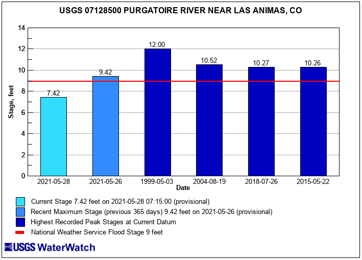
The flows on the Purgatoire River near Las Animas in Bent County are below minor flood stage. The graph below shows todays gauge height in feet at the Purgatoire River near Las Animas, next to the most recent flood stage report, and historical stages for context. The Purgatoire River and Cache la Poudre River are still experiencing higher than normal streamflow but are stable and below flood stage.

Click Here For Map Overview

The map below shows radar-estimated, rainfall gage-adjusted Quantitative Precipitation Estimates (QPE) across Colorado. The map is updated daily during the operational season (May 1 – Sep 30) by 11AM. The following six layers are currently available: 24-hour, 48-hour and 72-hour total precipitation, as well as maximum 1-hour, 2-hour and 6-hour precipitation over the past 24 hour period (to estimate where flash flooding may have occurred). The accumulation ending time is 7AM of the date shown in the bottom right corner. Also shown optionally are vulnerable fire burn areas (post 2012), which are updated throughout the season to include new, vulnerable burn areas. The home button in the top left corner resets the map to the original zoom.

Note: The 24-hour, 48-hour and 72-hour total precipitation do not contain bias corrections today due to errors in the CoCoRaHS data. This means there may be underestimations in QPE over the southwest and southeast corners of the state.