Issue Date: Sunday, May 30, 2021
Issue Time: 10:00 am MDT
Summary
Saturday was an active day for severe thunderstorms up and down the Eastern Plains, the Front Range Mountains, Palmer Ridge, and Raton Ridge. Storms began to form over the higher elevations in the early afternoon and made their way eastward, producing very heavy rain and large hail. For rainfall estimates in your area, check out our State Precipitation Map the bottom of this post.
Flash flood and flood warnings were issued for several storm cells that produced heavy rain, including for the Cameron Peak burn scar in Larimer County and the Junkins burn scar in Custer County. No flooding was reported over these burn scars yesterday.
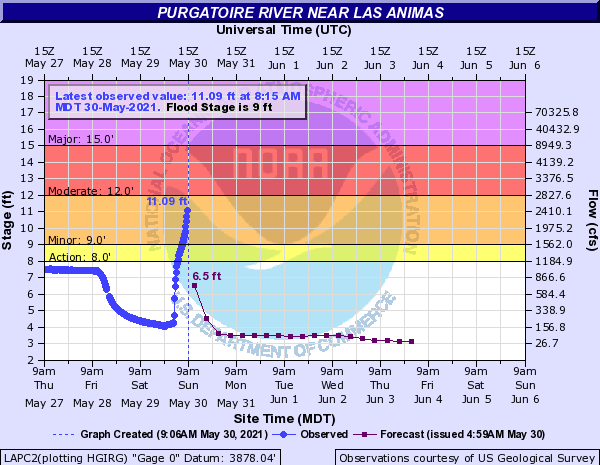
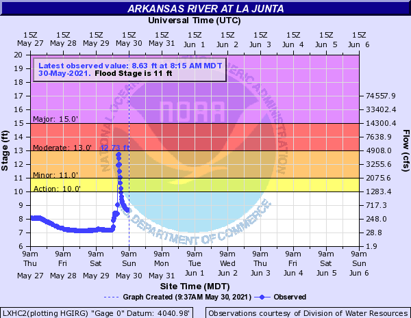
However, heavy precipitation continued well into the night last night, resulting in the Purgatoire River near Las Animas to reach minor flood stage (seen in the first hydrograph below). Additional flood reports from upstream near La Junta in the very early hours of the morning include high water flowing across State Highway 109, several homes flooded, and arroyos draining into the Arkansas River causing that river to also reach minor flood stage overnight, eventually cresting at 12.73 feet before coming back down below flood levels (second hydrograph below).
Click Here For Map Overview
Note: The 24-hour, 48-hour and 72-hour total precipitation do not contain bias corrections today due to errors in the CoCoRaHS data. This means there may be underestimations in QPE over the southwest and southeast corners of the state.


