SPM 07-10-2021: Severe Thunderstorms in East, Extreme Heat in West

Issue Date: Saturday, July 10, 2021
Issue Time: 9:00 AM MDT

Summary:

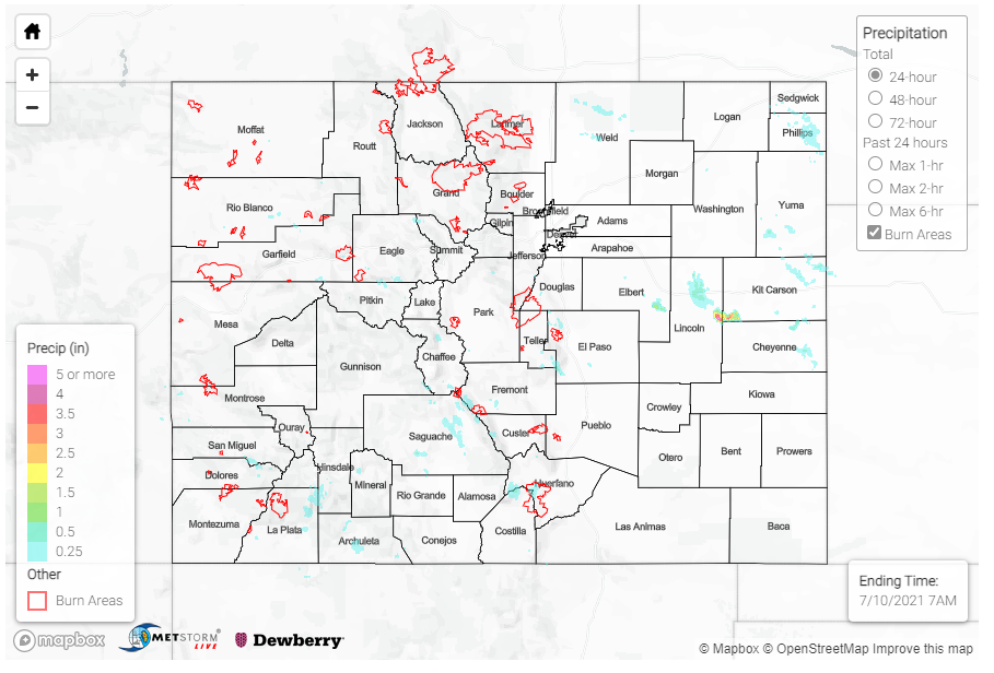
Isolated showers began to develop in the early afternoon in the Southwest Slope and San Juan Mountains, and along the Colorado-Wyoming Border in the Front Range Mountains yesterday before filling in to the Northern and Central Mountains and Palmer Divide as well. Locations lucky enough to be under a cell received heavy precipitation: 1.40 in was reported in Crestone according to a CoCoRaHS observer and nearby 0.75 inches was reported from Sand Dunes RAWS station. Elsewhere, a flash flood warning was issued in Central Grand County, though no flooding reported.

Gusty outflows from thunderstorm activity strengthened fire behavior on some of the high elevation fires. Another fire, the Morgan Creek Fire, was ignited in North Routt County mid-day.

As the day progressed, severe thunderstorms developed on the Northeast and Southeast Plains, with high winds as the biggest threat. Up to 86 mph wind gusts were reported in Granada in the southeast, and 70 mph in Iliff in the northeast. There were stiill some high precipitation totals associated with the storms on the Eastern Plains, including 0.69 from CoCoRaHS observer in Arriba in Lincoln County and 0.35 in Kit Carson. Check out the State Precipitation Map at the bottom of today’s post for rainfall estimates in your area.

The Northwest Slope and Grand Valley stayed dry yesterday, but experienced extremely hot conditions. Grand Junction saw all-time record setting heat yesterday, with a high of 107 degrees.

Click Here For Map Overview

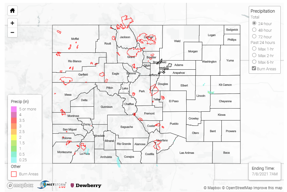
The map below shows radar-estimated, rainfall gage-adjusted Quantitative Precipitation Estimates (QPE) across Colorado. The map is updated daily during the operational season (May 1 – Sep 30) by 11AM. The following six layers are currently available: 24-hour, 48-hour and 72-hour total precipitation, as well as maximum 1-hour, 2-hour and 6-hour precipitation over the past 24 hour period (to estimate where flash flooding may have occurred). The 24-hour, 48-hour and 72-hour total precipitation contain bias corrections that are not disaggregated into the hourly estimates, so there will likely be some differences. The accumulation ending time is 7AM of the date shown in the bottom right corner. Also shown optionally are vulnerable fire burn areas (post 2012), which are updated throughout the season to include new, vulnerable burn areas. The home button in the top left corner resets the map to the original zoom.
Note: The 24-hour, 48-hour and 72-hour total precipitation do not contain bias corrections today due to errors in the CoCoRaHS data. This means there may be underestimations in QPE over the southwest and southeast corners of the state.
SPM 07-09-2021: Hot Day with Isolated Afternoon Thunderstorms

Issue Date: Friday, July 9, 2021
Issue Time: 9:50 AM MDT

Summary:

Yesterday was a hot one, which increased atmospheric stability across the state and limited precipitation overall. Still, isolated high elevation showers began to pop in the early afternoon and filled in as the afternoon progressed with a general eastward movement.

Light accumulations were reported by CoCoRaHS observers in the Northern, Central, and Front Range Mountains, as well as some in the Urban Corridor. Between 0.01-0.0.5 was reported across Fort Collins and Loveland. Totals were higher from isolated cells in the Southwest Slope and San Juan Mountains, including 0.31 inches in Nathrop, 0.46 inches in southern Saguache County, and 0.5 inches northwest of Pagosa Springs.

A flash flood warning was issued for the Spring Burn Scar in Costilla and Huerfano Counties after Doppler radar indicated heavy rain over the area. The Ute Creek SNOTEL station to the west of the burn scar reported 0.6 inches of rain throughout the day, confirming some heavy rainfall. However, no flooding was ultimately reported.

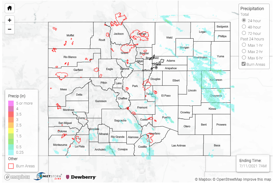
Looking at the State Precipitation Map below, there is an area of what appears to be very high rainfall on the Lincoln-Kit Carson-Cheyenne County borders. This is a radar artifact from a large wind farm producing clutter. There were still some isolated accumulations of note on the Eastern Plains though, 0.3-0.4 was reported in Cheyenne Wells. Additionally, a severe thunderstorm produced a short-lived dust storm that reduced visibility to near zero on the Colorado-Kansas border on I-70.

For rainfall estimates in your area, including antecedent rainfall totals, check out the State Precipitation Map below.

Click Here For Map Overview

The map below shows radar-estimated, rainfall gage-adjusted Quantitative Precipitation Estimates (QPE) across Colorado. The map is updated daily during the operational season (May 1 – Sep 30) by 11AM. The following six layers are currently available: 24-hour, 48-hour and 72-hour total precipitation, as well as maximum 1-hour, 2-hour and 6-hour precipitation over the past 24 hour period (to estimate where flash flooding may have occurred). The 24-hour, 48-hour and 72-hour total precipitation contain bias corrections that are not disaggregated into the hourly estimates, so there will likely be some differences. The accumulation ending time is 7AM of the date shown in the bottom right corner. Also shown optionally are vulnerable fire burn areas (post 2012), which are updated throughout the season to include new, vulnerable burn areas. The home button in the top left corner resets the map to the original zoom.
Note: The 24-hour, 48-hour and 72-hour total precipitation do not contain bias corrections today due to errors in the CoCoRaHS data. This means there may be underestimations in QPE over the southwest and southeast corners of the state.
SPM 07-08-2021: Much Dryer Across Colorado

Issue Date: Thursday, July 8, 2021
Issue Time: 9:15 AM MDT

Summary:

Wednesday, July 7 saw a high-pressure ridge settle into the southwest, bringing subsidence and higher temperatures to the state. Along with the ridge, a dryer air mass prevented all but very isolated showers, which for many was welcome news after several days of wet weather and flooding. Conversely, the warm and dry weather contributed to an increase in heat and fire activity for the Sylvan Fire and Muddy Slide fires yesterday.

The only notable precipitation in Colorado was around Durango in the Southwest Slope, where between 0.38-0.57 inches was reported after an isolated afternoon storm according to CoCoRaHS and MesoWest gages. There was also an isolated cell overnight on the Eastern Plains. However, due to the rural location there are no gage reports to verify magnitude. For rainfall estimates in your area check out the State Precipitation Map at the bottom of today’s post.

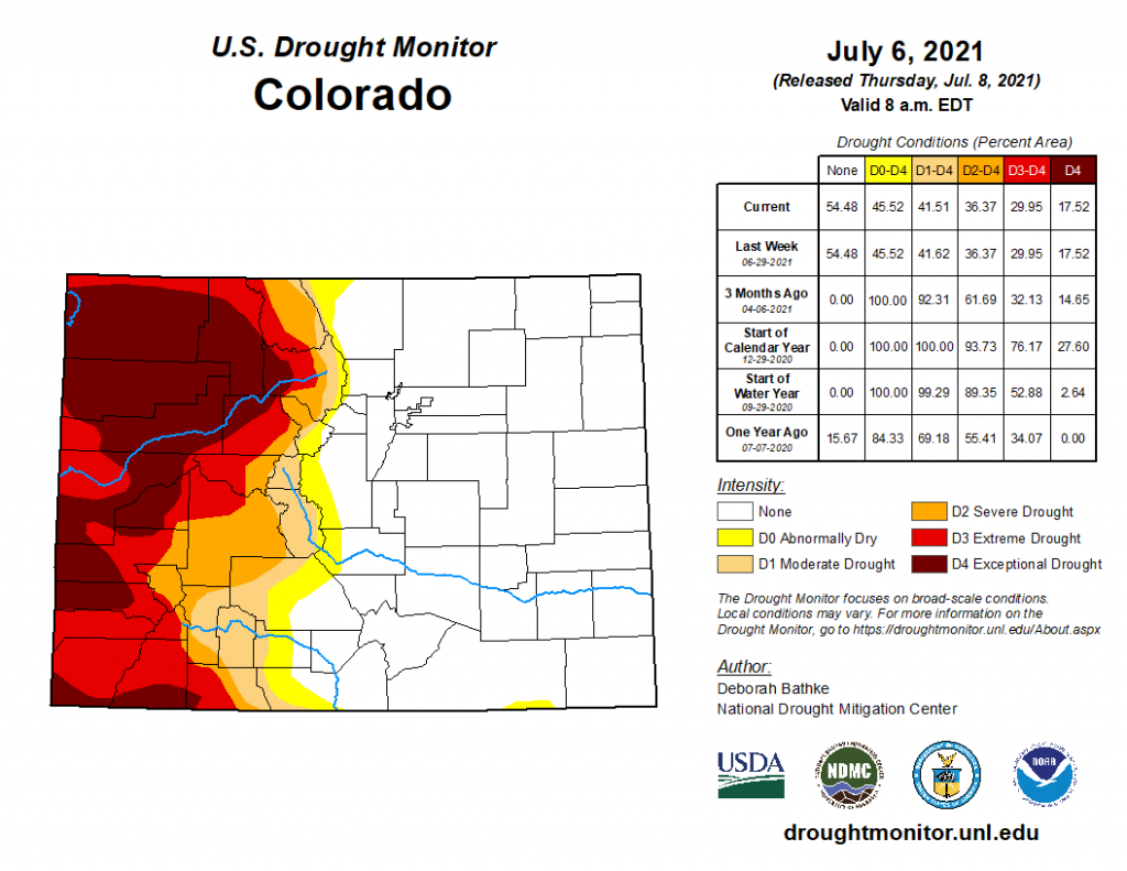
It has been a few weeks since the Drought Monitor was shared here, largely because there hasn’t been much change in drought conditions. The drastic divide between the eastern and western halves of the state still persists, with much of the west experiencing exceptional drought and no drought conditions in the east.

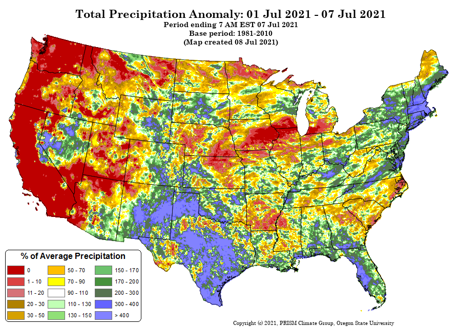
The total precipitation anomaly for the first week of July from PRISM shows that while some portions of Western Colorado have received above average precipitation for the first week of July, conditions have largely been dryer than normal for this time of year, explaining the continued long-term drought. Comparatively, some portions of the eastern half of the state, especially the southeast mountains, have received over 400% of average for the first week of July.

Click Here For Map Overview

The map below shows radar-estimated, rainfall gage-adjusted Quantitative Precipitation Estimates (QPE) across Colorado. The map is updated daily during the operational season (May 1 – Sep 30) by 11AM. The following six layers are currently available: 24-hour, 48-hour and 72-hour total precipitation, as well as maximum 1-hour, 2-hour and 6-hour precipitation over the past 24 hour period (to estimate where flash flooding may have occurred). The 24-hour, 48-hour and 72-hour total precipitation contain bias corrections that are not disaggregated into the hourly estimates, so there will likely be some differences. The accumulation ending time is 7AM of the date shown in the bottom right corner. Also shown optionally are vulnerable fire burn areas (post 2012), which are updated throughout the season to include new, vulnerable burn areas. The home button in the top left corner resets the map to the original zoom.
Note: The 24-hour, 48-hour and 72-hour total precipitation do not contain bias corrections today due to errors in the CoCoRaHS data. This means there may be underestimations in QPE over the southwest and southeast corners of the state.
SPM 07-07-2021: Heavy Rain and Flooding in Southern Colorado

Issue Date: Wednesday, July 7, 2021
Issue Time: 10:00 AM MDT

Summary:

Yesterday afternoon saw severe thunderstorms on the Southeast Plains and Raton Ridge. Storms were associated with a weak and very slow moving cold frontal passage, which produced lines of thunderstorms all the way from Wisconsin to Southeast Colorado. Storms spawned funnel clouds reported by trained spotters and simultaneous landspout tornadoes, in addition to the heavy rain from the slow-moving storms. Lamar picked up 0.73 inches of rain in just under an hour, and nearby Granada saw 0.76 inches in a 2-hour period. Storms continued their southeastward movement through the afternoon as the front exited the state.

Behind the front, thunderstorms began to develop in the late afternoon and evening in the Southeast, Central, and Front Range Mountains, with storms spilling into the Urban Corridor. Heavy rain for these late evening thunderstorms produced flooding in several locations across Southern Colorado.

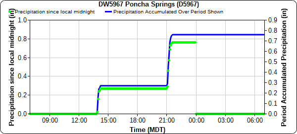
Heavy rain over Poncha Pass resulted in a series of slides that closed Highway 285 shortly after 10:00 pm last night. The time series plot from Poncha Springs shows the area received 0.76 inches of precipitation yesterday in two short bursts, one in the early afternoon around 2:00 pm, and then a greater pulse with around 0.5 inches of rain around 9:00 pm.

Colorado State Patrol in Florence shared the following picture of one of the debris flows on Twitter. Highway 285 has since opened this morning, but several vehicles, including a semi, were stranded overnight.

Another instance of flash flooding occurred on Texas Creek in Fremont County. According to law enforcement, Texas Creek washed out resulting in over 3 inches of water on County Road 21. Floodwaters also caused damage to county roads 2 and 16 as well. A CoCoRaHS observer in rural Fremont county northwest of Cañon City reported 0.71 total rainfall yesterday.

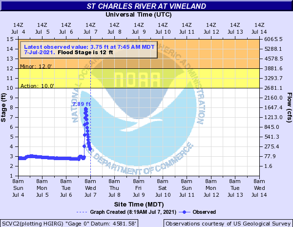
In Pueblo, 0.1 to nearly 1 inch of rain fell across the city and caused street flooding and closure of low-lying roads. East of Pueblo, the St. Charles River at Vineland stage quickly rose from around 3 feet to peaking at 7.89 feet in the early morning hours as a response to the heavy rain in the area.

For rainfall estimates in your area, check out the State Precipitation Map below.

Click Here For Map Overview

The map below shows radar-estimated, rainfall gage-adjusted Quantitative Precipitation Estimates (QPE) across Colorado. The map is updated daily during the operational season (May 1 – Sep 30) by 11AM. The following six layers are currently available: 24-hour, 48-hour and 72-hour total precipitation, as well as maximum 1-hour, 2-hour and 6-hour precipitation over the past 24 hour period (to estimate where flash flooding may have occurred). The 24-hour, 48-hour and 72-hour total precipitation contain bias corrections that are not disaggregated into the hourly estimates, so there will likely be some differences. The accumulation ending time is 7AM of the date shown in the bottom right corner. Also shown optionally are vulnerable fire burn areas (post 2012), which are updated throughout the season to include new, vulnerable burn areas. The home button in the top left corner resets the map to the original zoom.