Issue Date: Wednesday, July 7, 2021
Issue Time: 10:00 AM MDT
Summary:
Yesterday afternoon saw severe thunderstorms on the Southeast Plains and Raton Ridge. Storms were associated with a weak and very slow moving cold frontal passage, which produced lines of thunderstorms all the way from Wisconsin to Southeast Colorado. Storms spawned funnel clouds reported by trained spotters and simultaneous landspout tornadoes, in addition to the heavy rain from the slow-moving storms. Lamar picked up 0.73 inches of rain in just under an hour, and nearby Granada saw 0.76 inches in a 2-hour period. Storms continued their southeastward movement through the afternoon as the front exited the state.
Behind the front, thunderstorms began to develop in the late afternoon and evening in the Southeast, Central, and Front Range Mountains, with storms spilling into the Urban Corridor. Heavy rain for these late evening thunderstorms produced flooding in several locations across Southern Colorado.
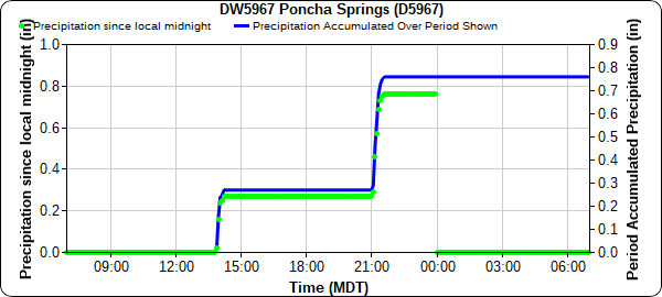
Heavy rain over Poncha Pass resulted in a series of slides that closed Highway 285 shortly after 10:00 pm last night. The time series plot from Poncha Springs shows the area received 0.76 inches of precipitation yesterday in two short bursts, one in the early afternoon around 2:00 pm, and then a greater pulse with around 0.5 inches of rain around 9:00 pm.
Colorado State Patrol in Florence shared the following picture of one of the debris flows on Twitter. Highway 285 has since opened this morning, but several vehicles, including a semi, were stranded overnight.
Poncha Pass mud slide pic.twitter.com/eepzM9OmPS
— CSP Florence (@CSP_Florence) July 7, 2021
Another instance of flash flooding occurred on Texas Creek in Fremont County. According to law enforcement, Texas Creek washed out resulting in over 3 inches of water on County Road 21. Floodwaters also caused damage to county roads 2 and 16 as well. A CoCoRaHS observer in rural Fremont county northwest of Cañon City reported 0.71 total rainfall yesterday.
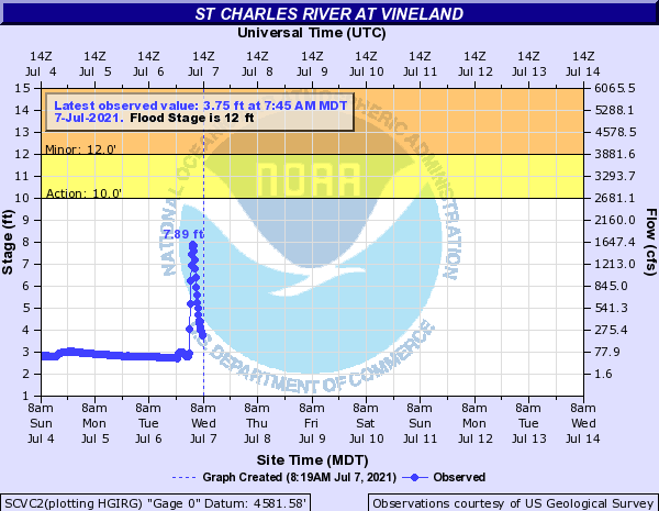
In Pueblo, 0.1 to nearly 1 inch of rain fell across the city and caused street flooding and closure of low-lying roads. East of Pueblo, the St. Charles River at Vineland stage quickly rose from around 3 feet to peaking at 7.89 feet in the early morning hours as a response to the heavy rain in the area.
For rainfall estimates in your area, check out the State Precipitation Map below.
Click Here For Map Overview

