SPM 09-16-2021: Return of Hot and Dry Weather

Issue Date: Thursday, September 16th, 2021
Issue Time: 9:45 AM MDT

Summary:

Wednesday saw the return of hot and dry weather across Colorado, and thanks to upper level high pressure over the state there is no rain to report. High temperatures were unseasonably warm yesterday, with 90s along the Urban Corridor and Northeast Plains, and 80s scattered across the high elevations and Western Slopes. In fact, September is on pace to be hottest on record in Denver.

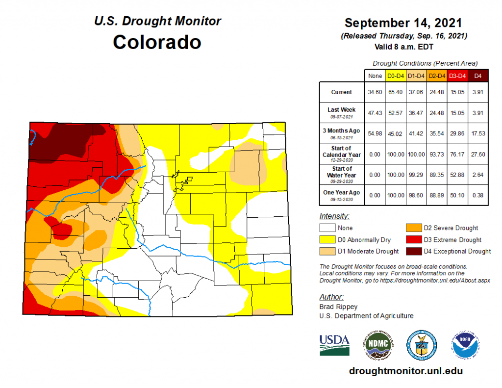
US Drought Monitor updates were published this morning, reflective of conditions up until Tuesday, 9/14, as seen in the map below. There has been no change in drought conditions west of the divide, moderate – exceptional drought still covers the western half other state, aside from areas of the San Juan Mountains and San Luis Valley. In Eastern Colorado, the area of “D0 Abnormally Dry” conditions has greatly increased from last week, up 13% in total area, extending north-south across the state on the Eastern Plains. Last weeks update included the Denver Metro Area, and the latest update now stretches across the Urban Corridor and Northeast Plains. A small area of Baca County on the Oklahoma border is now in “D1 Moderate Drought” as well.
There was no flooding reported on Wednesday. For rainfall estimates in your area, check out the State Precipitation Map below.

The Pueblo radar is currently being upgraded and is offline for the next few weeks, so radar-based precipitation estimates for Southeast Colorado are having to rely on further radars in Denver, New Mexico, Texas, and Kansas. This will result in precipitation being underestimated for this region. More information the radar upgrade can be found here.

Click Here For Map Overview

The map below shows radar-estimated, rainfall gage-adjusted Quantitative Precipitation Estimates (QPE) across Colorado. The map is updated daily during the operational season (May 1 – Sep 30) by 11AM. The following six layers are currently available: 24-hour, 48-hour and 72-hour total precipitation, as well as maximum 1-hour, 2-hour and 6-hour precipitation over the past 24 hour period (to estimate where flash flooding may have occurred). The accumulation ending time is 7AM of the date shown in the bottom right corner. Also shown optionally are vulnerable fire burn areas (post 2012), which are updated throughout the season to include new, vulnerable burn areas. The home button in the top left corner resets the map to the original zoom.

SPM 09-15-2021: Severe Thunderstorms, Heavy Rain for Southeast Colorado

Issue Date: Wednesday, September 15th, 2021
Issue Time: 10:20 AM MDT

Summary:

Portions of the Urban Corridor and Northeast Plains woke up to unusual early morning showers and thunderstorms Tuesday morning before quickly dissipating as the morning progressed. By afternoon, isolated convection began to fire up in the high elevations of the Northern, Central, Southeast, and Front Range Mountains before moving eastward. Storms became more widespread and organized on the Urban Corridor, Palmer Ridge, Southeast Plains, and Raton Ridge as well, as they formed along a surface low located to the southeast of Colorado near the Oklahoma panhandle. Large hail and high winds were the main threats from severe thunderstorms, but there was also plenty of moisture available for heavy rain.

In Colorado Springs, hail up to 1.25 inches was reported as Schriever AFB and there were several reports of heavy rain and minor street flooding across the city. Weather Nation shared the following video on twitter showing runoff from heavy rain. While some large, damaging hail was observed, most was smaller, pea-sized hail – just lots of it. Over 2 inches of hail was on the ground across Black Forest and Falcon, blanketing roads like snow, as seen in the tweet from Pueblo WFO.

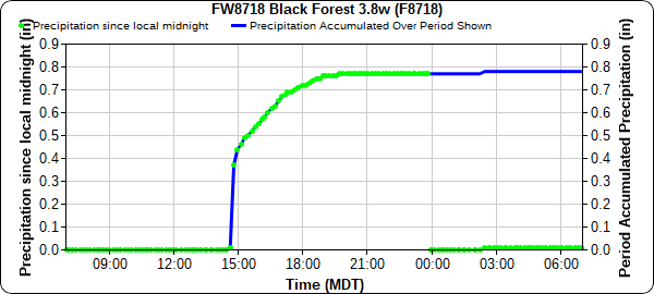
Up to 0.99 inches of rain accompanied the hail in Black Forest, according to CoCoRaHS observers, and 0.78 was recorded at the APRSWXNET gauge in the plot below. Rain began just before 3:00 pm with a quick burst of heavy rain, and then light accumulations throughout the evening. A bit further east, a CoCoRaHS observer in Peyton reported 0.90 inches of rain, with the following remark confirming the heavy rain and hail reports:

Rain and hail started at 3:25 PM yesterday and was over by 4:00 PM. There was almost 2″ of hail on the ground and still some this AM. Temp. at 3:31 yesterday got down to 45 degrees.

Severe thunderstorms caused wind damage in Ordway, La Junta, and Cheraw, where 2-3 inch tree limbs were downed and metal siding and roofing was damaged. In Cheraw alone, a 70 mph wind gust was reported by an ASOS station and a CoCoRaHS observer reported 1.70 inches of rain, which resulted in “flooding in the streets and yards.”

Some other notable rainfall totals in Southeast Colorado include:

  • 1.34 inches at Pinion Canyon RAWS
  • 1.24 inches east of Walsenburg from a CoCoRaHs observer
  • 0.88 inches at La Junta Municipal Airport

The Western Slopes and Grand Valley remained dry yesterday. For rainfall estimates in your area, check out the State Precipitation Map below. The Pueblo radar is currently being upgraded and is offline for the next few weeks, so radar-based precipitation estimates for Southeast Colorado are having to rely on further radars in Denver, New Mexico, Texas, and Kansas. This will result in precipitation being underestimated, which is especially apparent from some of the higher precipitation totals observed yesterday compared to the map. More information the radar upgrade can be found here.

Click Here For Map Overview
The map below shows radar-estimated, rainfall gage-adjusted Quantitative Precipitation Estimates (QPE) across Colorado. The map is updated daily during the operational season (May 1 – Sep 30) by 11AM. The following six layers are currently available: 24-hour, 48-hour and 72-hour total precipitation, as well as maximum 1-hour, 2-hour and 6-hour precipitation over the past 24 hour period (to estimate where flash flooding may have occurred). The accumulation ending time is 7AM of the date shown in the bottom right corner. Also shown optionally are vulnerable fire burn areas (post 2012), which are updated throughout the season to include new, vulnerable burn areas. The home button in the top left corner resets the map to the original zoom.

SPM 09-14-2021: Evening Thunderstorms for Northeast Colorado

Issue Date: Tuesday, September 14th, 2021
Issue Time: 10:20 AM MDT

Summary:

Monday morning kicked off with some cloud coverage and showers along the Wyoming border in the Northern and Front Range Mountains before dissipating and lifting to the north through morning. By early afternoon, isolated convection began to build in the Northwest Slope and Northern Mountains, filling in by late afternoon along the Front Range Mountains, Urban Corridor, Palmer Ridge, and Northeast Plains as well. Zonal west-east flow across Colorado kept storm motion moving quickly eastward, and also acted to limit precipitation to the northern half of the state. The evening hours ended up more eventful than the rest of the day, with widespread thunderstorm activity in the Urban Corridor, Palmer Ridge, and Northeast Plains starting around 7:00 pm yesterday, lasting well into the night.

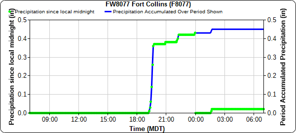
Fort Collins and Central Weld County were the biggest winners in terms of precipitation yesterday. The Colorado State University weather station observed 0.47 inches beginning after 7:00 yesterday evening, as seen in the time series plot below.

A nearby CoCoRaHS station to the east of campus also reported a similar 0.48 inches, along with the following remark:

“Intermittent strong storm of rain, thunder and lightning starting at 6:50 PM into 1010 PM and beyond”

Similar rainfall totals were seen north of Greely – a PWS in Eaton reported 0.53 inches of rain yesterday between 8:30 pm and 12:30 am. Storms mostly dissipated in the early morning hours, though a weak boundary remained and those in Denver and Boulder woke up to some unusual early morning thunder today.

Conditions remained largely dry for Southern Colorado, though thankfully not as hot as the last several days. The NWS office in Pueblo shared the following tweet with a bit of humor after Alamosa finally DID NOT set a record high temperature yesterday.

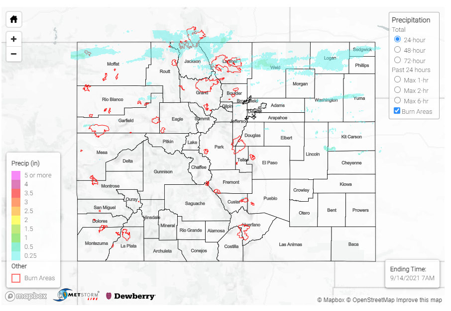
Flooding was not reported on Monday. For rainfall estimates in your area, check out the State Precipitation Map below. An area of higher rainfall totals can be seen in Lincoln-Kit Carson-Cheyenne counties, however this actually not rainfall but a radar artifact due to wind turbines in the area.

Click Here For Map Overview

The map below shows radar-estimated, rainfall gage-adjusted Quantitative Precipitation Estimates (QPE) across Colorado. The map is updated daily during the operational season (May 1 – Sep 30) by 11AM. The following six layers are currently available: 24-hour, 48-hour and 72-hour total precipitation, as well as maximum 1-hour, 2-hour and 6-hour precipitation over the past 24 hour period (to estimate where flash flooding may have occurred). The accumulation ending time is 7AM of the date shown in the bottom right corner. Also shown optionally are vulnerable fire burn areas (post 2012), which are updated throughout the season to include new, vulnerable burn areas. The home button in the top left corner resets the map to the original zoom.

Note: The 24-hour, 48-hour and 72-hour total precipitation do not contain bias corrections today due to errors in the CoCoRaHS data. This means there may be underestimations in QPE over the southwest and southeast corners of the state.

SPM 09-13-2021: Severe Thunderstorms on Eastern Plains

Issue Date: Monday, September 13th, 2021
Issue Time: 10:05 AM MDT

Summary:

Some northern portions of the Urban Corridor and Northeast Plains woke up to light showers Sunday morning along a weak trough axis, before moving eastward and lifting out of the state in the early afternoon. By that time, daytime heating allowed for convection to fire up in the Northern, Central, San Juan, and Front Range Mountains, while spilling onto the Urban Corridor and Palmer Ridge. As the afternoon progressed, thunderstorms became more organized on the Palmer Ridge, and Northeast and Southeast Plains. High winds were the main threat from these storms, though areas lucky enough to be under a thunderstorm did receive higher precipitation totals. A funnel cloud was reported by a pilot on the way to Colorado Springs, though it was not visible from ground. Additionally, up to 0.50 inches of rain was reported from CoCoRaHS observers in Colorado Springs, and 0.81 inches in Security. A bit northeast, thunderstorms produced 0.48 inches in Frankton, 0.67 inches of rain in Kiowa, and 0.83 inches in Agate.

By evening, severe thunderstorm warnings were issued for widespread storms on the Northeast and Southeast Plains. Up to 60 mph thunderstorm wind gusts were reported in Wild Horse in Cheyenne County. Nearby in Cheyenne Wells, up to 0.25 inch hail was reported and between 0.78-1.69 inches of rain from CoCoRaHS observers in town. Precipitation Frequency Estimates from NOAA Atlas 14 for Cheyenne Wells put 1.69 inches in a 6-hour period, just below a 2-year Average Recurrence Interval (or greater than 50% chance of occurring in any given year). A second round of thunderstorms formed further south by evening, dropping 0.46 inches of rain in Holly.

Even with the widespread showers, it was still a very hot day for September, especially for southern Colorado. Alamosa broke their daily record high temperature, reaching 86 degrees yesterday, topping the previous record of 84 set in 1956.

As things calmed down in eastern Colorado overnight, a weak cold front entered the state from the northwest during the very early morning hours. While most of the action has remained north of the Colorado border into Wyoming, there has been some light accumulations this morning.

No flooding was reported on Sunday. For rainfall estimates in your area, check out the State Precipitation Map below.

Click Here For Map Overview

The map below shows radar-estimated, rainfall gage-adjusted Quantitative Precipitation Estimates (QPE) across Colorado. The map is updated daily during the operational season (May 1 – Sep 30) by 11AM. The following six layers are currently available: 24-hour, 48-hour and 72-hour total precipitation, as well as maximum 1-hour, 2-hour and 6-hour precipitation over the past 24 hour period (to estimate where flash flooding may have occurred). The accumulation ending time is 7AM of the date shown in the bottom right corner. Also shown optionally are vulnerable fire burn areas (post 2012), which are updated throughout the season to include new, vulnerable burn areas. The home button in the top left corner resets the map to the original zoom.