Issue Date: Tuesday, September 14th, 2021
Issue Time: 10:20 AM MDT
Summary:
Monday morning kicked off with some cloud coverage and showers along the Wyoming border in the Northern and Front Range Mountains before dissipating and lifting to the north through morning. By early afternoon, isolated convection began to build in the Northwest Slope and Northern Mountains, filling in by late afternoon along the Front Range Mountains, Urban Corridor, Palmer Ridge, and Northeast Plains as well. Zonal west-east flow across Colorado kept storm motion moving quickly eastward, and also acted to limit precipitation to the northern half of the state. The evening hours ended up more eventful than the rest of the day, with widespread thunderstorm activity in the Urban Corridor, Palmer Ridge, and Northeast Plains starting around 7:00 pm yesterday, lasting well into the night.
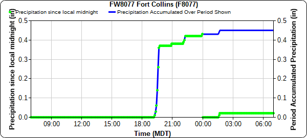
Fort Collins and Central Weld County were the biggest winners in terms of precipitation yesterday. The Colorado State University weather station observed 0.47 inches beginning after 7:00 yesterday evening, as seen in the time series plot below.
A nearby CoCoRaHS station to the east of campus also reported a similar 0.48 inches, along with the following remark:
“Intermittent strong storm of rain, thunder and lightning starting at 6:50 PM into 1010 PM and beyond”
Similar rainfall totals were seen north of Greely – a PWS in Eaton reported 0.53 inches of rain yesterday between 8:30 pm and 12:30 am. Storms mostly dissipated in the early morning hours, though a weak boundary remained and those in Denver and Boulder woke up to some unusual early morning thunder today.
Conditions remained largely dry for Southern Colorado, though thankfully not as hot as the last several days. The NWS office in Pueblo shared the following tweet with a bit of humor after Alamosa finally DID NOT set a record high temperature yesterday.
Alamosa did NOT break or tie a record high temperature today. This has been the first day a record wasn't tied or broken since September 6th. #COwx #Colorado
— NWS Pueblo (@NWSPueblo) September 13, 2021
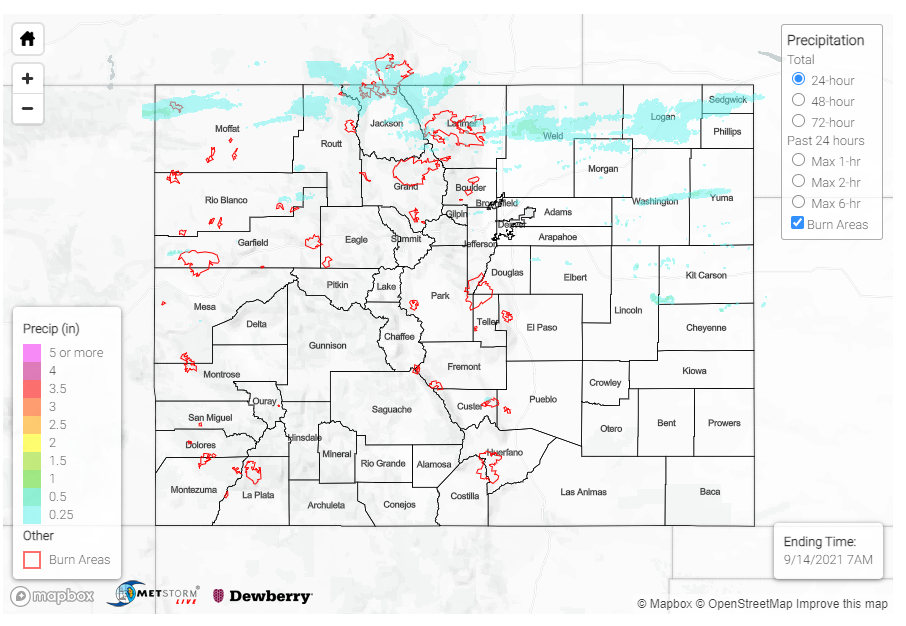
Flooding was not reported on Monday. For rainfall estimates in your area, check out the State Precipitation Map below. An area of higher rainfall totals can be seen in Lincoln-Kit Carson-Cheyenne counties, however this actually not rainfall but a radar artifact due to wind turbines in the area.
Click Here For Map Overview
Note: The 24-hour, 48-hour and 72-hour total precipitation do not contain bias corrections today due to errors in the CoCoRaHS data. This means there may be underestimations in QPE over the southwest and southeast corners of the state.

