Issue Date: Wednesday, September 15th, 2021
Issue Time: 10:20 AM MDT
Summary:
Portions of the Urban Corridor and Northeast Plains woke up to unusual early morning showers and thunderstorms Tuesday morning before quickly dissipating as the morning progressed. By afternoon, isolated convection began to fire up in the high elevations of the Northern, Central, Southeast, and Front Range Mountains before moving eastward. Storms became more widespread and organized on the Urban Corridor, Palmer Ridge, Southeast Plains, and Raton Ridge as well, as they formed along a surface low located to the southeast of Colorado near the Oklahoma panhandle. Large hail and high winds were the main threats from severe thunderstorms, but there was also plenty of moisture available for heavy rain.
In Colorado Springs, hail up to 1.25 inches was reported as Schriever AFB and there were several reports of heavy rain and minor street flooding across the city. Weather Nation shared the following video on twitter showing runoff from heavy rain. While some large, damaging hail was observed, most was smaller, pea-sized hail – just lots of it. Over 2 inches of hail was on the ground across Black Forest and Falcon, blanketing roads like snow, as seen in the tweet from Pueblo WFO.
Heavy rain and hail hit the Colorado Springs area on Tuesday, and fortunately for this trash can, a car was there to prevent it from flowing down the road. #cowx pic.twitter.com/hQPolcYqZz
— WeatherNation (@WeatherNation) September 15, 2021
Here’s a photo from the CDOT camera in Falcon showing hail accumulation across the roadway. Even though the size of the hail may not be too large, the accumulation of this hail could provide hazardous conditions. If you are traveling across these areas, please use caution. #cowx pic.twitter.com/YuClv8oxFF
— NWS Pueblo (@NWSPueblo) September 14, 2021
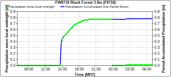
Up to 0.99 inches of rain accompanied the hail in Black Forest, according to CoCoRaHS observers, and 0.78 was recorded at the APRSWXNET gauge in the plot below. Rain began just before 3:00 pm with a quick burst of heavy rain, and then light accumulations throughout the evening. A bit further east, a CoCoRaHS observer in Peyton reported 0.90 inches of rain, with the following remark confirming the heavy rain and hail reports:
Rain and hail started at 3:25 PM yesterday and was over by 4:00 PM. There was almost 2″ of hail on the ground and still some this AM. Temp. at 3:31 yesterday got down to 45 degrees.
Severe thunderstorms caused wind damage in Ordway, La Junta, and Cheraw, where 2-3 inch tree limbs were downed and metal siding and roofing was damaged. In Cheraw alone, a 70 mph wind gust was reported by an ASOS station and a CoCoRaHS observer reported 1.70 inches of rain, which resulted in “flooding in the streets and yards.”
Some other notable rainfall totals in Southeast Colorado include:
- 1.34 inches at Pinion Canyon RAWS
- 1.24 inches east of Walsenburg from a CoCoRaHs observer
- 0.88 inches at La Junta Municipal Airport
The Western Slopes and Grand Valley remained dry yesterday. For rainfall estimates in your area, check out the State Precipitation Map below. The Pueblo radar is currently being upgraded and is offline for the next few weeks, so radar-based precipitation estimates for Southeast Colorado are having to rely on further radars in Denver, New Mexico, Texas, and Kansas. This will result in precipitation being underestimated, which is especially apparent from some of the higher precipitation totals observed yesterday compared to the map. More information the radar upgrade can be found here.
Click Here For Map Overview

