SPM 05-02-2022: Widespread Precipitation in Northern Colorado

Issue Date: Monday, May 2nd, 2022
Issue Time: 10:50 AM MDT

Summary:

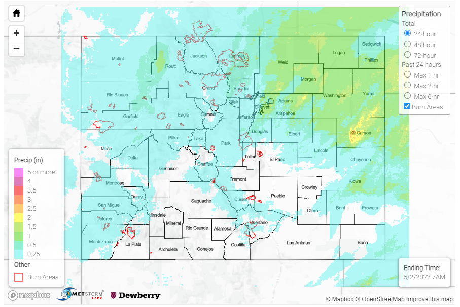
What a way to kick off May and the first forecast day of the season! As discussed in the FTB yesterday, a fast-moving upper level low pressure system brought widespread precipitation across the northern half of the state. 24-hour rainfall totals between 0.30-0.50 inches and higher were recorded across Fort Collins, and totals were even higher according to CoCoRaHS observers across the Northeast Plains. Notable observations include:

  • 1.10 inches in Sterling (Logan County)
  • 0.92 inches in Yuma (Yuma County)
  • 0.90 inches in Fort Morgan (Morgan County) with a nearby observer remarks that it’s “still coming down”

The Colorado Climate Center shared the following tweet this morning celebrating Northern Colorado’s much needed moisture from the system.

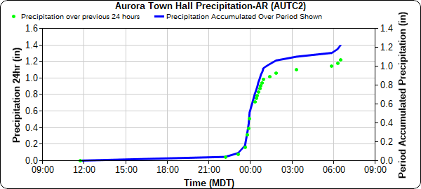
Overnight, a thunderstorm between Denver and Aurora produced impressive rainfall totals over 1 inch, verified by both CoCoRaHS observers and the MHFD gauge network. The Aurora Town Hall recorded 1.26 inches of rain yesterday, with most of that falling between 11 pm and 2 am, as seen in the hyetograph below. Several small creek/river gauges across the Metro Area are at all-time high for day of year, including Harvard Gulch and Toll Gate Creek in Denver.

For portions of Southeast Colorado, severe storms impacted the area yesterday evening. In Prowers County, 1.25 inch hail was reported in Lamar and 1.75 inch hail in Bristol, accompanied with thunderstorm wind gusts exceeding 60 mph. The first tornado warning for the state was also issued yesterday for a severe cell across Prowers and Bent counties, though no tornado was observed.

In the higher elevations, yesterday’s precipitation fell as snow and wintry mix with many mountain locations picking up an inch or more of snow. A total of 3.0 inches in was reported from a CoCoRaHS observer in Oak Creek (Southern Routt County) and 5.0 inches in Crested Butte (Gunnison County)!

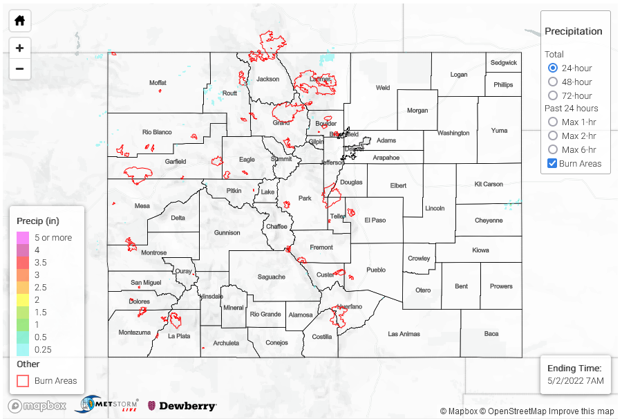
Elsewhere in the state, conditions were generally dry across Southern Colorado. For the Western Slopes and Grand Valley high winds were reported, ranging between 45-55 mph across region and up to 63 mph wind gust on Douglas Pass in Garfield County. There were no flood reports yesterday. For rainfall estimates in your area, check out the MetStormLive QPE below.
Click Here For Map Overview

The map below shows radar-estimated, rainfall gage-adjusted Quantitative Precipitation Estimates (QPE) across Colorado. The map is updated daily during the operational season (May 1 – Sep 30) by 11AM. The following six layers are currently available: 24-hour, 48-hour and 72-hour total precipitation, as well as maximum 1-hour, 2-hour and 6-hour precipitation over the past 24 hour period (to estimate where flash flooding may have occurred). The accumulation ending time is 7AM of the date shown in the bottom right corner. Also shown optionally are vulnerable fire burn areas (post 2012), which are updated throughout the season to include new, vulnerable burn areas. The home button in the top left corner resets the map to the original zoom.

SPM 05-01-2022: Welcome back to the State Precipitation Map

Issue Date: Sunday, May 1st, 2022
Issue Time: 11:35 AM MDT

Summary:

Welcome back to the State Precipitation Map for the 2022 season! The end of April finished uneventfully yesterday in terms of precipitation across the state, though April 2022 has finished as one of the windiest Aprils on record in Denver. To kick off the season, let’s take a look at the state of the snowpack and drought conditions across Colorado.

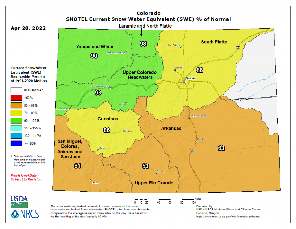
Snowmelt season has begun and as of April 29 statewide snowpack is at 80 percent of the median, according to the NRCS. However, as you can see in the map below of Snow Water Equivalent (SWE), basins in the northern half of the state are faring better than their southern counterparts. The Yampa and White, Laramie and North Platte, and Upper Colorado basins are currently at 90% of SWE or greater, with the South Platte and Gunnison Basins not far behind. However, in Southern Colorado the Arkansas, San Miguel-Dolores-Animas-San Juan, and Upper Rio Grande basins are between only 53-63% of normal.

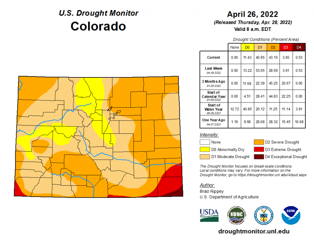
According to the latest map from the US Drought Monitor below, the entire state is experiencing drought conditions in some form. This ranges from Abnormally Dry (D0) conditions for portions of the Northern, Central, and Front Range Mountains, along with the Grand Valley, all the way to Exceptional Drought (D4) on the Southeast Plains. The vast majority of the state, over 80% in total area, is experiencing Moderate (D1) to Severe (D2) Drought.

While the current state of snowpack and drought may paint a bleak picture for the upcoming warm season, look to each day’s Flood Threat Bulletin and twice-weekly Flood Threat Outlooks to understand the potential for extreme rainfall and floods. If you happen to observe flooding this season, be sure to use our “Report a Flood” tool if you can safely do so. Flood reports from the public help verify forecasts and provide important ground-truth to Quantitative Precipitation Estimates.

There were no flood or heavy rain reports yesterday. For rainfall estimates in your area, check out the MetStormLive QPE below.
Click Here For Map Overview

The map below shows radar-estimated, rainfall gage-adjusted Quantitative Precipitation Estimates (QPE) across Colorado. The map is updated daily during the operational season (May 1 – Sep 30) by 11AM. The following six layers are currently available: 24-hour, 48-hour and 72-hour total precipitation, as well as maximum 1-hour, 2-hour and 6-hour precipitation over the past 24 hour period (to estimate where flash flooding may have occurred). The accumulation ending time is 7AM of the date shown in the bottom right corner. Also shown optionally are vulnerable fire burn areas (post 2012), which are updated throughout the season to include new, vulnerable burn areas. The home button in the top left corner resets the map to the original zoom.

SPM 09-30-2021: Widespread, Soaking Rainfall for Much of Colorado

Issue Date: Thursday, September 30th, 2021
Issue Time: 10:35 AM MDT

Summary:

Wednesday was another wet day for much of Colorado. It started off with morning showers and thunderstorms, including snow at high elevations, for the Grand Valley, Western Slopes, Central, and Northern Mountains associated with the eastward progression of a strong shortwave trough. Another morning of heavy rain combined with high accumulations yesterday resulted in several western locations experiencing flooding and debris flows.

A Flash Flood Warning was issued for the Grizzly Creek burn area before 9 am, indicating that flash flooding was already occurring in Glenwood Canyon due to heavy rain and thunderstorms, as per emergency managers. I-70 was closed by CDOT in both directions after the warning was issued – CDOT also confirmed a mud flow in the canyon, as seen in the tweets below.

A USGS gauge at Deadman’s Creek Met Station Near Glenwood Springs, reported 0.98 inches of rain yesterday and 2.33 inches in the last two days. CoCoRaHS observers around Glenwood Springs reported 0.62-0.73 inches of rain as well yesterday. A Flood Advisory was also issued for Fruita at 12:24 pm, with the language of the advisory indicating that minor flooding was also occurring due to heavy rainfall in the Little Salt Wash Creek.

On the flip side, the Ptarmigan Fire in the Central Mountains benefited from the late morning/early afternoon rainfall. The following is an excerpt from a last night’s news release:

The rain has not extinguished the fire, but it has helped reduce fire activity, which allowed firefighters to make good progress building containment lines on the southern and western flanks today. Weather limited the use of helicopters today.
Fire officials currently estimate the Ptarmigan Fire to be between 85 and 100 acres with no containment. The cause remains under investigation.

Rainfall totals around Silverthorne were less impressive, but the I-70 corridor received up to 0.39 inches of rain yesterday.

While storms dissipated from the west in the early afternoon, showers also began to pick up along the Front Range Mountains and spill into the Urban Corridor. A widespread north-south line of storms covered most of the urban corridor, bringing isolated heavy rainfall and minor runoff and street flooding. Small stream flood advisories were issued for Larimer County, including portions of Cameron Peak burn area, and Boulder County for the Calwood burn area. Both burn scars had moderate threats forecasted in the FBF yesterday, but thankfully no flooding was reported. 24-hour rainfall totals across the Urban Corridor range from less than 0.10 inches in Fort Collins and Loveland, 0.44 inches in Boulder, 0.65 in Lakewood, and 0.84 inches in Castle Rock.

Back west, another round of thunderstorms picked up again for Grand Valley and Southwest Slope in the evening. A debris flow was reported by a NWS employee in Whitewater, Southeast of Grand Junction after 5:00 pm indicating “6 to 8 inches of water and mud flowing across driveway”. Up to 0.25 inch hail was also reported from evening thunderstorms nearby in Skyway. Rainfall totals across the Grand Valley vary from 1.33 inches in Glade Park, 1.08 in Redlands, 0.33-0.68 in Grand Junction, and 0.58 in Palisade and Cedaredge. In the Southwest Slope, Montrose received 0.64 inches of rain, 0.41 in Ridgeway, 0.35 in Rico, and 0.25 in Ignacio.

The Southeast Mountains, Raton Ridge, and Southeast Plains had their turn for rainfall in the late evening, which lasted well into the overnight hours. A series of special weather statements for 50 mph winds, small hail, and frequent lightning (sub-severe thunderstorms) were issued by the Pueblo WFO yesterday evening for strong storms in Southeast Mountains and Southeast Plains. Hail up to 0.88 inches was reported in Aguilar. Some notable rainfall totals in the Southeast Mountains and Plains include:

  • 1.27 in Colorado City
  • 1.00 in Crowley
  • 0.97 in Cedarwood
  • 0.87 in Ordway (who remarked that things were so dry before this rain there was still hardly any mud)
  • 0.84 in Walsenburg
  • 0.72 in Rocky Ford

This morning US141 closed in both directions from a rock slide between Naturita and 15 miles south of Gateway – tweet from CDOT below. Due to the very rural location in this part of the state, there are few gauges to verify how much rain fell over the area. A MesoWest gauge at Nucla received 0.05 inches yesterday, which isn’t much. However, MetStormLive QPE in the State Precipitation Map below indicates up to 0.25 inches fell across the area.

The only portions of the state that remained overall dry yesterday were the San Luis Valley and Northeast Plains. For rainfall estimates in your area, check out the State Precipitation Map below.

Click Here For Map Overview

The map below shows radar-estimated, rainfall gage-adjusted Quantitative Precipitation Estimates (QPE) across Colorado. The map is updated daily during the operational season (May 1 – Sep 30) by 11AM. The following six layers are currently available: 24-hour, 48-hour and 72-hour total precipitation, as well as maximum 1-hour, 2-hour and 6-hour precipitation over the past 24 hour period (to estimate where flash flooding may have occurred). The accumulation ending time is 7AM of the date shown in the bottom right corner. Also shown optionally are vulnerable fire burn areas (post 2012), which are updated throughout the season to include new, vulnerable burn areas. The home button in the top left corner resets the map to the original zoom.

Note: The 24-hour, 48-hour and 72-hour total precipitation do not contain bias corrections today due to errors in the CoCoRaHS data. This means there may be underestimations in QPE over the southwest and southeast corners of the state.

SPM 09-29-2021: Much Needed Rainfall for Western Colorado, but Debris Flow on Pine Gulch Burn Scar

Issue Date: Wednesday, September 29th, 2021
Issue Time: 10:45 AM MDT

Summary:

Portions of the Urban Corridor and Northeast Plains woke up to some isolated showers Tuesday morning before quickly dissipating. However, the main weather story from yesterday is definitely the significant rainfall for Western Colorado. Scattered showers began to develop in the late morning in the Grand Valley and Northwest Slope associated with the late-season plume of monsoon moisture brought into the region by the cutoff low. By afternoon with the east-northeast progression of the low, there were scattered but widespread showers and thunderstorms over the Western Slopes, Grand Valley, Northern, Central, San Juan, and Southeast Mountains – even allowing for snow to fall at the highest elevations. Eventually, the eastward progression also caused enough lift for isolated shower coverage along the Palmer Ridge and Eastern Plains.

Back in the west, by early evening a trough axis moving in from Utah allowed for another round of widespread showers over the Western Slopes, Grand Valley, Northern, Central, and San Juan mountains. This provided soaking, long-duration rainfall (with some localized embedded convection) that lasted overnight and into the morning today. Rainfall totals west of the divide are impressive for late September, which is especially helpful with the drought conditions that have been plaguing the western half of the state all summer

Up to 1.30 inches was reported in Grand Junction near Colorado National Monument from a CoCoRaHS observer who also remarked:

“Rain started about 2:30 PM and was intermittent throughout the night. Heaviest rain occurred about 5:30 PM with 0.60 inches in 20 minutes causing street flooding.”

There are no precipitation frequency estimates from NOAA Atlas 14 for 20-minutes, but 0.60 inches in 30 minutes falls between a 5-year and 10-year Average Recurrence Interval (ARI) for this area, or 10-20% chance of occurring in any given year; 1.30 inches in 24-hours falls just below the 5-year ARI threshold. In addition to the heavy rain, up to 0.25 inch hail was reported nearby in Redlands, along with runoff on the roads. Other rainfall totals around Grand Junction range between 0.23 on the east side of town, and up to 0.87 in Loma and 0.69 in Fruita.

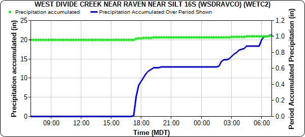
A series of arroyo and small stream flood advisories were issued north and south of Grand Junction and a flash flood warning was issued for the Pine Gulch burn area. Due to the rural nature of the burn area there are limited gauges, however West Divide Creek Station managed by CO-DWR, just southeast of the burn area, reported 1.09 inches in 24-hours, as seen in the hyetograph below. Additional gauges north of the burn area recorded between 0.58-1.53 inches of rain in 24-hours. Unfortunately, heavy rain resulted in a debris flow in De Beque, which flooded a house and rerouted Roan Creek.

A CoCoRaHS observer in Dinosaur reported 1.74 inches of rain yesterday, starting around 6:30 pm and continuing into the morning with many periods of heavy rain during the night. Precipitation Frequency Estimates for Dinosaur place 1.74 inches in 24-hours between a 10-year and 25-year ARI (or 4-10% chance in any given year). Other notable rainfall totals from Western Colorado include:

  • 1.28 in New Castle
  • 0.94-1.04 across Steamboat Springs
  • 0.86 in Parachute and Edwards, mostly from a single thunderstorm but light rain continued on/off through night
  • 0.81 in Walden
  • 0.75 in Mancos
  • 0.47-0.62 across Glenwood Springs and Carbondale
  • 0.60 in Gypsum
  • 0.53 in Cortez and Durango
  • 0.52 in Ouray

Between 0.25 and 1.04 inches of rain fell in Silverthorne and along the I-70 corridor west of the tunnels, which was helpful for moderating fire behavior from the Ptarmigan fire, but also limited firefighting efforts by grounding aircraft. As of last night, the fire has burned over 85 acres with no containment and is near residential areas. The Front Range Mountains, Urban Corridor, and Eastern Plains had much lighter precipitation accumulations yesterday – between Trace and 0.15 inches. For rainfall estimates in your area, check out the State Precipitation Map below.

Click Here For Map Overview

The map below shows radar-estimated, rainfall gage-adjusted Quantitative Precipitation Estimates (QPE) across Colorado. The map is updated daily during the operational season (May 1 – Sep 30) by 11AM. The following six layers are currently available: 24-hour, 48-hour and 72-hour total precipitation, as well as maximum 1-hour, 2-hour and 6-hour precipitation over the past 24 hour period (to estimate where flash flooding may have occurred). The accumulation ending time is 7AM of the date shown in the bottom right corner. Also shown optionally are vulnerable fire burn areas (post 2012), which are updated throughout the season to include new, vulnerable burn areas. The home button in the top left corner resets the map to the original zoom.