Issue Date: Wednesday, September 29th, 2021
Issue Time: 10:45 AM MDT
Summary:
Portions of the Urban Corridor and Northeast Plains woke up to some isolated showers Tuesday morning before quickly dissipating. However, the main weather story from yesterday is definitely the significant rainfall for Western Colorado. Scattered showers began to develop in the late morning in the Grand Valley and Northwest Slope associated with the late-season plume of monsoon moisture brought into the region by the cutoff low. By afternoon with the east-northeast progression of the low, there were scattered but widespread showers and thunderstorms over the Western Slopes, Grand Valley, Northern, Central, San Juan, and Southeast Mountains – even allowing for snow to fall at the highest elevations. Eventually, the eastward progression also caused enough lift for isolated shower coverage along the Palmer Ridge and Eastern Plains.
Back in the west, by early evening a trough axis moving in from Utah allowed for another round of widespread showers over the Western Slopes, Grand Valley, Northern, Central, and San Juan mountains. This provided soaking, long-duration rainfall (with some localized embedded convection) that lasted overnight and into the morning today. Rainfall totals west of the divide are impressive for late September, which is especially helpful with the drought conditions that have been plaguing the western half of the state all summer
Up to 1.30 inches was reported in Grand Junction near Colorado National Monument from a CoCoRaHS observer who also remarked:
“Rain started about 2:30 PM and was intermittent throughout the night. Heaviest rain occurred about 5:30 PM with 0.60 inches in 20 minutes causing street flooding.”
There are no precipitation frequency estimates from NOAA Atlas 14 for 20-minutes, but 0.60 inches in 30 minutes falls between a 5-year and 10-year Average Recurrence Interval (ARI) for this area, or 10-20% chance of occurring in any given year; 1.30 inches in 24-hours falls just below the 5-year ARI threshold. In addition to the heavy rain, up to 0.25 inch hail was reported nearby in Redlands, along with runoff on the roads. Other rainfall totals around Grand Junction range between 0.23 on the east side of town, and up to 0.87 in Loma and 0.69 in Fruita.
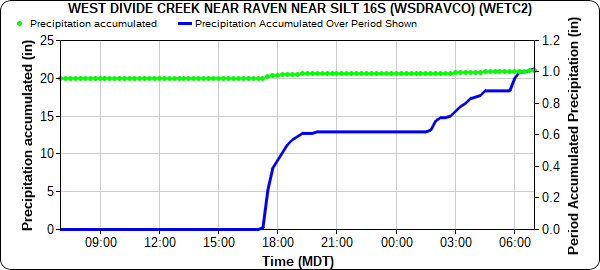
A series of arroyo and small stream flood advisories were issued north and south of Grand Junction and a flash flood warning was issued for the Pine Gulch burn area. Due to the rural nature of the burn area there are limited gauges, however West Divide Creek Station managed by CO-DWR, just southeast of the burn area, reported 1.09 inches in 24-hours, as seen in the hyetograph below. Additional gauges north of the burn area recorded between 0.58-1.53 inches of rain in 24-hours. Unfortunately, heavy rain resulted in a debris flow in De Beque, which flooded a house and rerouted Roan Creek.
A CoCoRaHS observer in Dinosaur reported 1.74 inches of rain yesterday, starting around 6:30 pm and continuing into the morning with many periods of heavy rain during the night. Precipitation Frequency Estimates for Dinosaur place 1.74 inches in 24-hours between a 10-year and 25-year ARI (or 4-10% chance in any given year). Other notable rainfall totals from Western Colorado include:
- 1.28 in New Castle
- 0.94-1.04 across Steamboat Springs
- 0.86 in Parachute and Edwards, mostly from a single thunderstorm but light rain continued on/off through night
- 0.81 in Walden
- 0.75 in Mancos
- 0.47-0.62 across Glenwood Springs and Carbondale
- 0.60 in Gypsum
- 0.53 in Cortez and Durango
- 0.52 in Ouray
Between 0.25 and 1.04 inches of rain fell in Silverthorne and along the I-70 corridor west of the tunnels, which was helpful for moderating fire behavior from the Ptarmigan fire, but also limited firefighting efforts by grounding aircraft. As of last night, the fire has burned over 85 acres with no containment and is near residential areas. The Front Range Mountains, Urban Corridor, and Eastern Plains had much lighter precipitation accumulations yesterday – between Trace and 0.15 inches. For rainfall estimates in your area, check out the State Precipitation Map below.
Click Here For Map Overview

