Issue Date: Monday, May 2nd, 2022
Issue Time: 10:50 AM MDT
Summary:
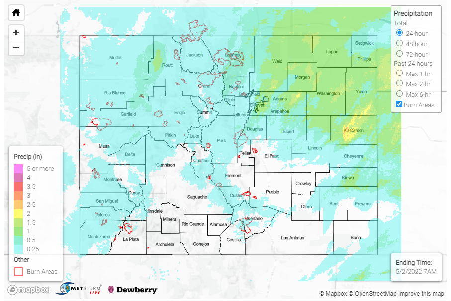
What a way to kick off May and the first forecast day of the season! As discussed in the FTB yesterday, a fast-moving upper level low pressure system brought widespread precipitation across the northern half of the state. 24-hour rainfall totals between 0.30-0.50 inches and higher were recorded across Fort Collins, and totals were even higher according to CoCoRaHS observers across the Northeast Plains. Notable observations include:
- 1.10 inches in Sterling (Logan County)
- 0.92 inches in Yuma (Yuma County)
- 0.90 inches in Fort Morgan (Morgan County) with a nearby observer remarks that it’s “still coming down”
The Colorado Climate Center shared the following tweet this morning celebrating Northern Colorado’s much needed moisture from the system.
Not a drought-buster, and not everyone got rain (yet…more still to come), but cause for a little bit of #cowx celebration 🎉 pic.twitter.com/QcBgOjgbbv
— ColoClimateCenter (@ColoradoClimate) May 2, 2022
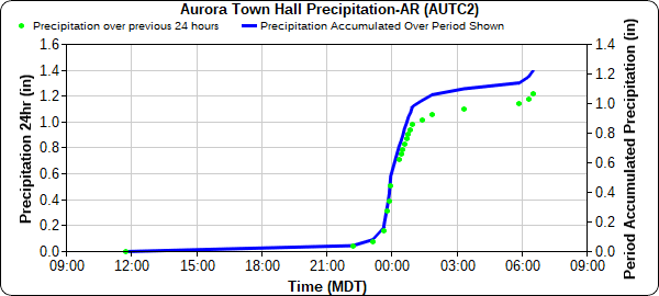
Overnight, a thunderstorm between Denver and Aurora produced impressive rainfall totals over 1 inch, verified by both CoCoRaHS observers and the MHFD gauge network. The Aurora Town Hall recorded 1.26 inches of rain yesterday, with most of that falling between 11 pm and 2 am, as seen in the hyetograph below. Several small creek/river gauges across the Metro Area are at all-time high for day of year, including Harvard Gulch and Toll Gate Creek in Denver.
For portions of Southeast Colorado, severe storms impacted the area yesterday evening. In Prowers County, 1.25 inch hail was reported in Lamar and 1.75 inch hail in Bristol, accompanied with thunderstorm wind gusts exceeding 60 mph. The first tornado warning for the state was also issued yesterday for a severe cell across Prowers and Bent counties, though no tornado was observed.
In the higher elevations, yesterday’s precipitation fell as snow and wintry mix with many mountain locations picking up an inch or more of snow. A total of 3.0 inches in was reported from a CoCoRaHS observer in Oak Creek (Southern Routt County) and 5.0 inches in Crested Butte (Gunnison County)!
Elsewhere in the state, conditions were generally dry across Southern Colorado. For the Western Slopes and Grand Valley high winds were reported, ranging between 45-55 mph across region and up to 63 mph wind gust on Douglas Pass in Garfield County. There were no flood reports yesterday. For rainfall estimates in your area, check out the MetStormLive QPE below.

