SPM 05-10-2022: Dry, Windy Conditions Continue

Issue Date: Tuesday, May 10th, 2022
Issue Time: 10:40 AM MDT

Summary:

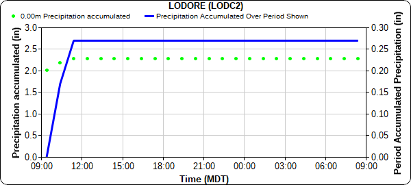
Northwest Colorado, including the Northwest Slope and Northern Mountains saw some early morning rain and snow showers yesterday, which quickly diminished as the day progressed. Precipitation totals across the region were very low, ranging from only Trace to about 0.15 inches, with the exception of the extreme northwest corner of the state. Two MesoWest Gauges in Moffat County near the Utah and Wyoming borders picked up 0.27 and 0.32 inches of rainfall. Due to the remote location and distance from any radars, these observations are not easily reflected in the QPE below. The hyetograph for Lodore, north of Dinosaur National Monument, shows the brief 0.27 inches of precipitation just after 9 am yesterday.

For the remainder of the state, it was unfortunately another day with not much else to report besides heat and high winds. While peak gusts were slightly lower than yesterday, high winds were still reported across Western and Southern Colorado. Walsenburg, which reported an 86-mph gust two days ago, saw another 77 mph non-thunderstorm gust yesterday. In terms of temperature, stations all across the Southeast Plains reached into the 90s yesterday including 97 degrees in Lamar and 98 in Granada!

There were no flood reports yesterday. For rainfall estimates in your area, check out the MetStorm Live QPE below.

Click Here For Map Overview
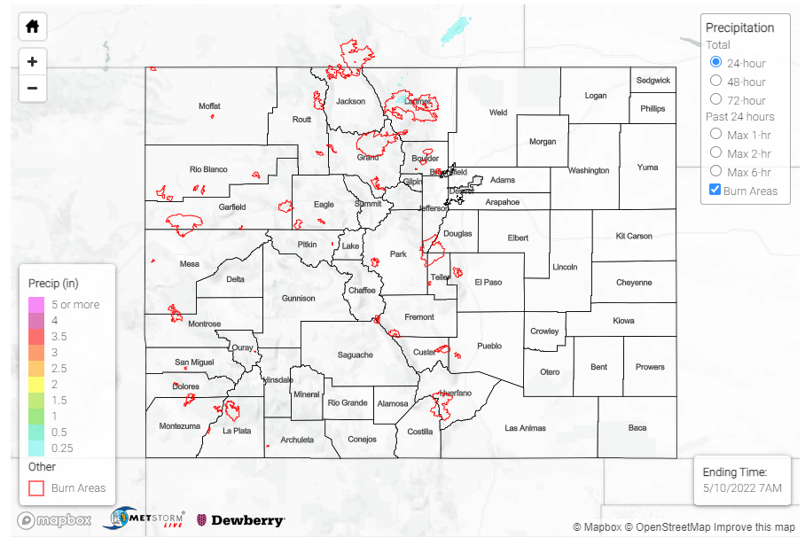
The map below shows radar-estimated, rainfall gage-adjusted Quantitative Precipitation Estimates (QPE) across Colorado. The map is updated daily during the operational season (May 1 – Sep 30) by 11AM. The following six layers are currently available: 24-hour, 48-hour and 72-hour total precipitation, as well as maximum 1-hour, 2-hour and 6-hour precipitation over the past 24 hour period (to estimate where flash flooding may have occurred). The accumulation ending time is 7AM of the date shown in the bottom right corner. Also shown optionally are vulnerable fire burn areas (post 2012), which are updated throughout the season to include new, vulnerable burn areas. The home button in the top left corner resets the map to the original zoom.

SPM 05-09-2022: Exceptionally Windy Day Across Colorado

Issue Date: Monday, May 9th, 2022
Issue Time: 11:30 AM MDT

Summary:

Yesterday saw some modest precipitation associated with a shortwave’s passage through the Northwest Slope and Northern Mountains during the late evening and overnight hours, with snow falling at higher elevations. A CoCoRaHS observer in Oak Creek, in Routt County, received 1.5 of snow yesterday (though only 0.10 inches of liquid equivalent), and left the following remark on their daily report:

“Well, woke up to a snowy surprise. Also, noting that there is a pink tinge to the snow. Desert dust? It was very windy the last 24 hours.”

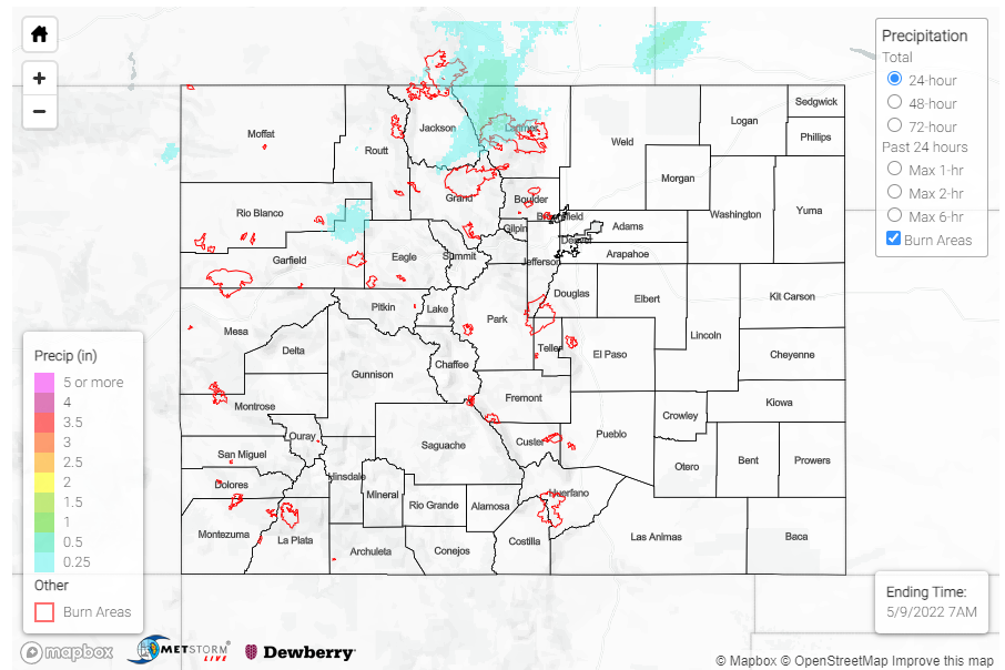
Based on their note, a bit of tint to the snow along with the noted high winds makes their guess of desert dust the likely culprit. Generally, precipitation totals were between Trace-0.15 inches for the Northwest Slope, Northern Mountains, and a bit of spillover to the Front Range and Urban Corridor. The rest of the state remained dry.

The main weather story for yesterday though was the continued wind. High wind reports were recorded all over Western and Southern Colorado, though conditions were blustery really everywhere. Gusts over 80 mph were recorded in Huerfano, San Miguel, Garfield, and Pueblo counties – including an 86-mph guest in Walsenburg yesterday afternoon!

There were no flood reports yesterday. For rainfall estimates in your area, check out the MetStorm Live QPE below.

Click Here For Map Overview

The map below shows radar-estimated, rainfall gage-adjusted Quantitative Precipitation Estimates (QPE) across Colorado. The map is updated daily during the operational season (May 1 – Sep 30) by 11AM. The following six layers are currently available: 24-hour, 48-hour and 72-hour total precipitation, as well as maximum 1-hour, 2-hour and 6-hour precipitation over the past 24 hour period (to estimate where flash flooding may have occurred). The accumulation ending time is 7AM of the date shown in the bottom right corner. Also shown optionally are vulnerable fire burn areas (post 2012), which are updated throughout the season to include new, vulnerable burn areas. The home button in the top left corner resets the map to the original zoom.

SPM 05-08-2022: Frontal Passage Brings High Winds, Rain to Northern Colorado

Issue Date: Sunday, May 8th, 2022
Issue Time: 10:30 AM MDT

Summary:

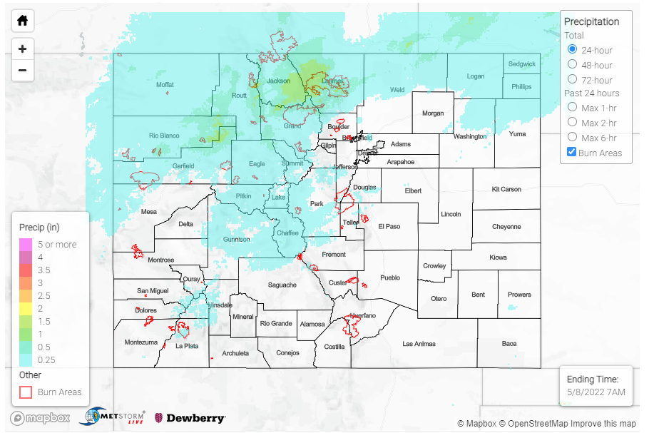
A frontal passage traversed the state yesterday, bringing additional moisture in the late afternoon to overnight hours for Northern Colorado. Rain, heavy at times, was reported for much of the Northwest Slope and Northern Mountains, as well as northern portions of Front Range Mountains and Urban Corridor. Snow was also reported at some of the higher elevations, including Cameron Pass. Notable precipitation totals from CoCoRaHS observers across the state include:

  • 0.50 in Grand Lake– where observers noted this was the first rain report for their gauge of the season
  • 0.48 in Kremmling
  • 0.44 in Steamboat Springs
  • 0.34 in Estes Park and
  • 0.05-0.25 across Fort Collins

Non-thunderstorm wind gusts were also reported all across the Western Slopes and Grand Valley. The Grand Junction NWS Office shared the following tweet with peak wind gusts from yesterday.

While wind speeds were not nearly as high as out west, windy conditions kicked up a dust storm along in the Urban Corridor/Palmer Ridge yesterday as well. Southern Colorado remained largely dry, with those high winds providing all the ingredients for critical fire weather.

There were no flood reports yesterday. For rainfall estimates in your area, check out the MetStorm Live QPE below.

Click Here For Map Overview

The map below shows radar-estimated, rainfall gage-adjusted Quantitative Precipitation Estimates (QPE) across Colorado. The map is updated daily during the operational season (May 1 – Sep 30) by 11AM. The following six layers are currently available: 24-hour, 48-hour and 72-hour total precipitation, as well as maximum 1-hour, 2-hour and 6-hour precipitation over the past 24 hour period (to estimate where flash flooding may have occurred). The accumulation ending time is 7AM of the date shown in the bottom right corner. Also shown optionally are vulnerable fire burn areas (post 2012), which are updated throughout the season to include new, vulnerable burn areas. The home button in the top left corner resets the map to the original zoom.

SPM 05-07-2022: Warm, Dry, and Breezy Day Across Colorado

Issue Date: Saturday, May 7th, 2022
Issue Time: 10:10 AM MDT

Summary:

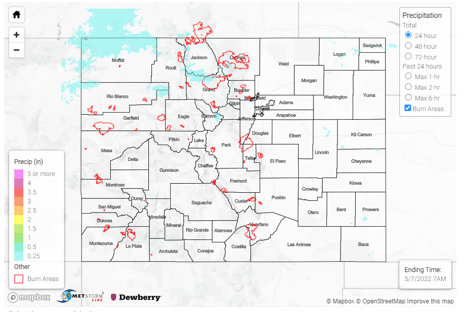
As mentioned in yesterday’s FTB, a ridge of high pressure settling in over the state kept conditions windy and dry yesterday with not much measurable precipitation to report. It was unseasonably warm as well, with high temperatures reaching into the 80s for much of the eastern half of the state and west slopes, and even in the 70s in the mountains. Colorado Springs tied their record high of 83 yesterday – the NWS in Pueblo shared the tweet below with some more information, though the record was not officially broken. One of the hottest places in the state was Granada in the Southeast Plains, which reached a daily high of 91 yesterday!

There were no flood reports yesterday. For rainfall estimates in your area, check out the MetStorm Live QPE below.

Click Here For Map Overview
The map below shows radar-estimated, rainfall gage-adjusted Quantitative Precipitation Estimates (QPE) across Colorado. The map is updated daily during the operational season (May 1 – Sep 30) by 11AM. The following six layers are currently available: 24-hour, 48-hour and 72-hour total precipitation, as well as maximum 1-hour, 2-hour and 6-hour precipitation over the past 24 hour period (to estimate where flash flooding may have occurred). The accumulation ending time is 7AM of the date shown in the bottom right corner. Also shown optionally are vulnerable fire burn areas (post 2012), which are updated throughout the season to include new, vulnerable burn areas. The home button in the top left corner resets the map to the original zoom.