SPM 05-26-2022: Sunshine!

Issue Date: Thursday, May 26th, 2022
Issue Time: 10:00 AM MDT

Summary:

After nearly a week of cold and soggy conditions, sunshine returned across the state on Wednesday, while temperatures began to rebound back towards seasonal values. Nearly the entire state was precipitation-free yesterday, save for a handful of stations that reported a trace to a few hundredths of an inch of precipitation.

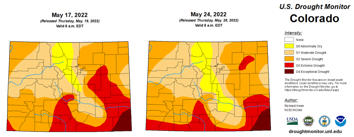
The U.S. Drought Monitor was updated this morning, with notable improvements in drought conditions across portions of eastern Colorado. The Palmer Ridge saw a reduction in extreme drought, while portions of Park, Teller, Fremont, El Paso, and Pueblo counties went from moderate drought back to abnormally dry.

In terms of statewide percentages, moderate drought went from 93.5% coverage down to 89.7%, severe drought went from 63.9% coverage down to 59.6%, and extreme drought went from 23% coverage down to 18.1%. While we still have a very long way to go, any precipitation helps, and the rain and snow this past week was certainly welcome.

Several creek and river flows across the state, most notably the Arkansas River at Las Animas, remain above normal, but none are in flood stage.

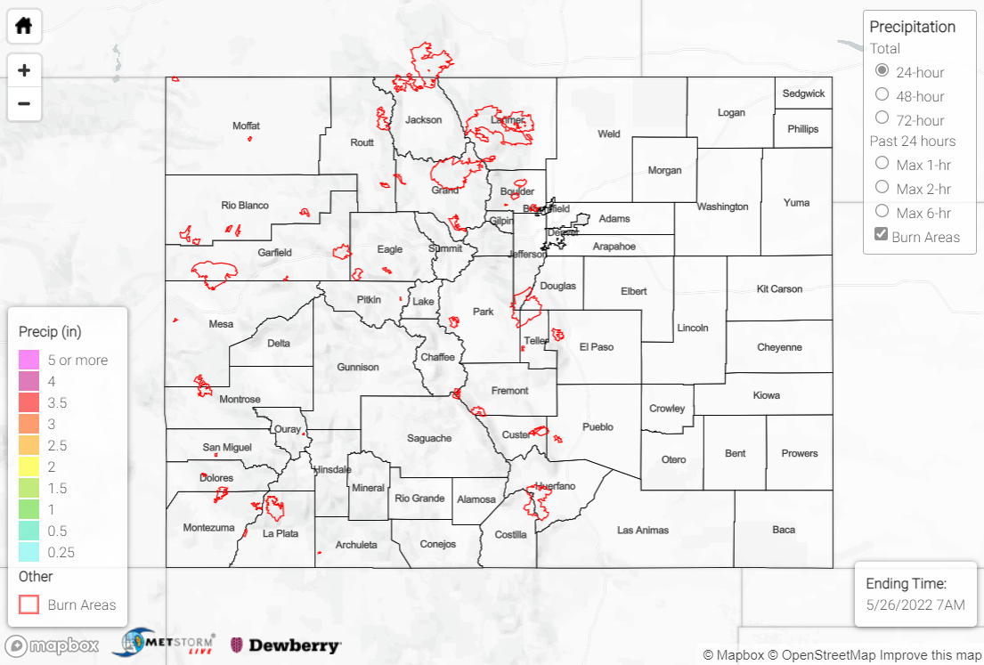
There was no flooding reported yesterday. For precipitation estimates in your area over the last few days, check out the map below.
Click Here For Map Overview

The map below shows radar-estimated, rainfall gage-adjusted Quantitative Precipitation Estimates (QPE) across Colorado. The map is updated daily during the operational season (May 1 – Sep 30) by 11AM. The following six layers are currently available: 24-hour, 48-hour and 72-hour total precipitation, as well as maximum 1-hour, 2-hour and 6-hour precipitation over the past 24 hour period (to estimate where flash flooding may have occurred). The accumulation ending time is 7AM of the date shown in the bottom right corner. Also shown optionally are vulnerable fire burn areas (post 2012), which are updated throughout the season to include new, vulnerable burn areas. The home button in the top left corner resets the map to the original zoom.

SPM 05-25-2022: Last Day of Rain and Snow before Dry Weather Returns

Issue Date: Wednesday, May 25th, 2022
Issue Time: 9:45 AM MDT

Summary:

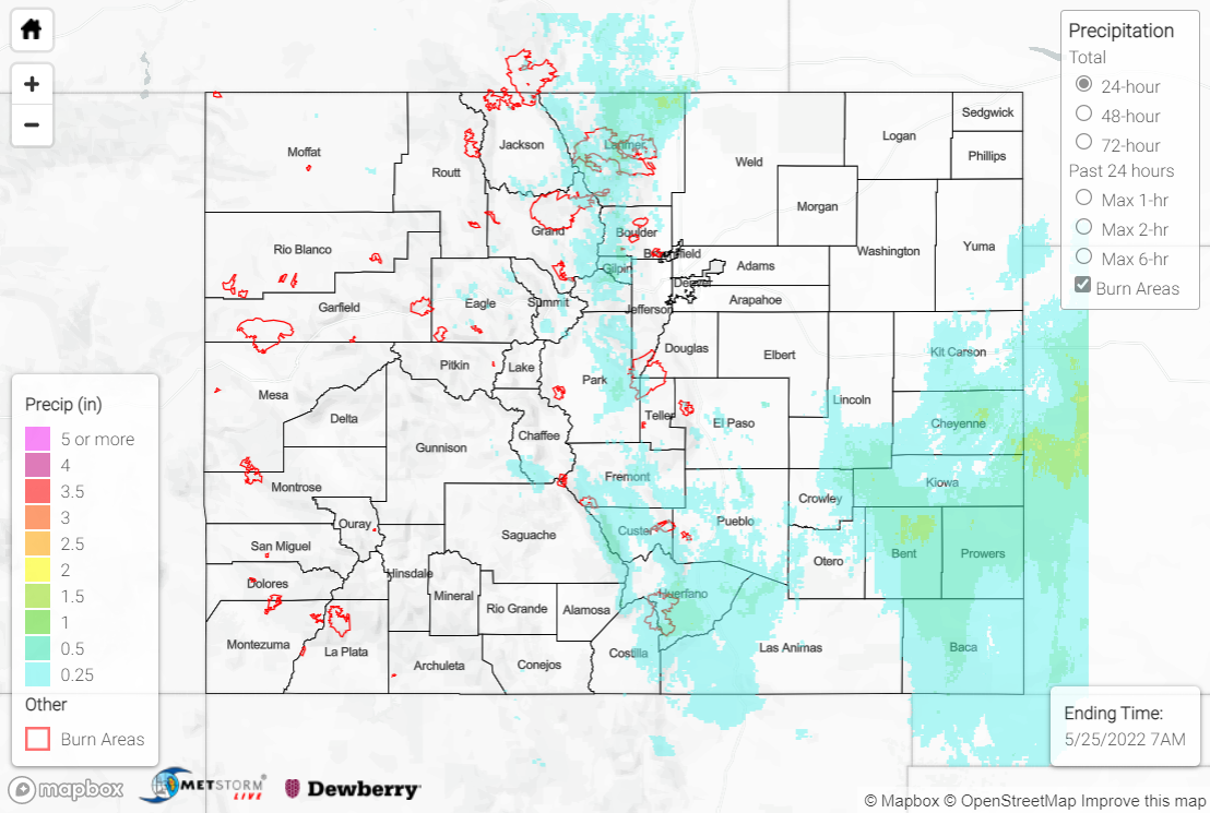
The upper-level trough responsible for our weather on Monday remained slow to depart the region on Tuesday, producing the final day of a prolonged stretch of cool and wet weather across the state. Once again, large-scale ascent and northerly upslope flow combined to produce rain and snow east of the divide. Rainfall amounts along the urban corridor were generally 0.25” or less, while the southeastern plains saw heavier rainfall totals approaching and exceeding 1”, especially Bent, Prowers, and Baca counties. A CoCoRaHS observer in Holly near the Kansas border reported 1.08” of rainfall, which was the highest precipitation total across the state.

Snowfall yesterday was confined to the high country along the urban corridor, where the previously dwindling snowpack was once again replenished with fresh powder. The central Front Range saw over half a foot, with 8.6” reported by CoCoRaHS observers near both Nederland and Dumont. The rest of the high country saw a trace to a few inches at most. The fresh snowpack on Pikes Peak was easily visible in the clear skies this morning behind yesterday’s departing storm system:

Precipitation rates on Tuesday were generally light to moderate. Several streams, creeks and rivers across the state, most notably the Arkansas River at Las Animas, are running above normal after the precipitation the past few days, but none are in flood stage.

There was no flooding reported yesterday. For precipitation estimates in your area over the last few days, check out the map below.
Click Here For Map Overview

The map below shows radar-estimated, rainfall gage-adjusted Quantitative Precipitation Estimates (QPE) across Colorado. The map is updated daily during the operational season (May 1 – Sep 30) by 11AM. The following six layers are currently available: 24-hour, 48-hour and 72-hour total precipitation, as well as maximum 1-hour, 2-hour and 6-hour precipitation over the past 24 hour period (to estimate where flash flooding may have occurred). The accumulation ending time is 7AM of the date shown in the bottom right corner. Also shown optionally are vulnerable fire burn areas (post 2012), which are updated throughout the season to include new, vulnerable burn areas. The home button in the top left corner resets the map to the original zoom.

SPM 05-24-2022: Another Cool and Wet Day East of the Divide

Issue Date: Tuesday, May 24th, 2022
Issue Time: 11:30 AM MDT

Summary:

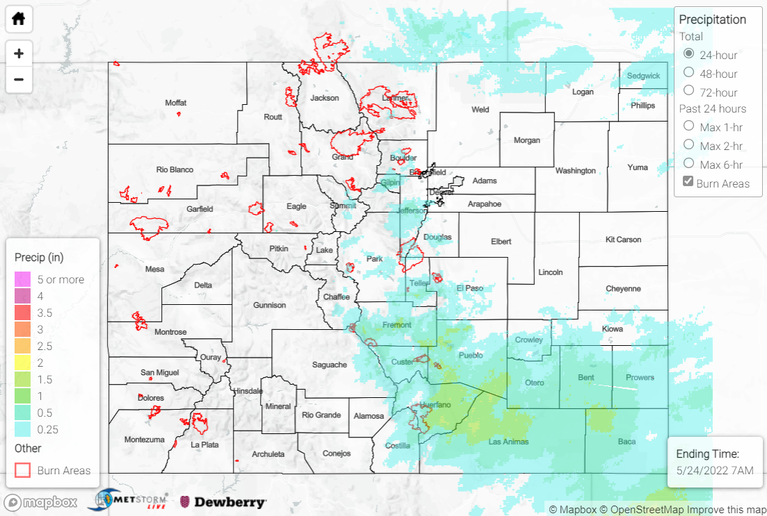
Monday saw another cool and wet day east of the continental divide, as an expansive upper-level trough continued to dominate the weather across much of the intermountain west. Large-scale ascent associated with this trough, as well as upslope flow at the surface across the eastern plains, combined to create widespread rain and snow. While precipitation lingered throughout much of the day, especially across the southeastern quadrant of the state, precipitation intensity remained light to moderate due to the lack of convection. Snowfall was confined to the high elevations west of I-25 and east of the divide, with minimal travel impacts owing to the relatively mild air and ground temperatures this time of year.

Precipitation along the northern urban corridor generally ranged from 0.25-0.75”, with most of this falling as rain. A few higher elevation locations in the north saw heavier totals nearing and exceeding 1”, including CoCoRaHS reports of 1.20” near Fairplay and 1.73” near Buena Vista, although most of this precipitation fell as snow. The highest precipitation totals were observed across the southern urban corridor and the southeastern plains of Huerfano, Las Animas, and Baca Counties, with widespread totals exceeding 1” and approaching 1.50″; this is where the most persistent precipitation was observed over the last 24 hours.

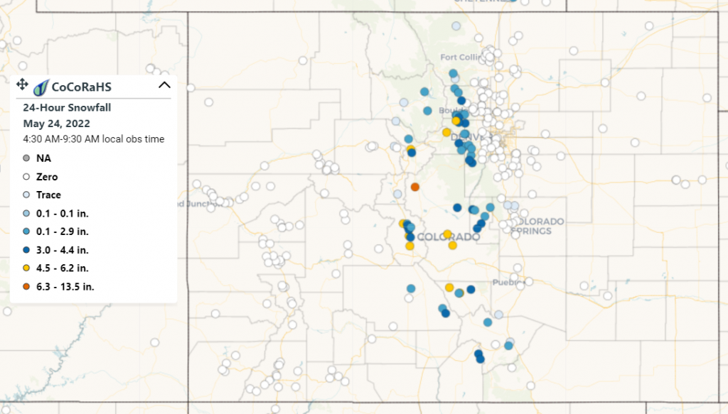
As mentioned above, high elevations received yet another late season boost to their declining snowpack. The highest snowfall amounts per CoCoRaHS were observed in the vicinity of South Park, with totals ranging from half a foot to a maximum of 13.5” near Fairplay; outside of this area, locations generally saw only a trace to several inches.

There was no flooding reported yesterday. For precipitation estimates in your area over the last few days, check out the map below.
Click Here For Map Overview

The map below shows radar-estimated, rainfall gage-adjusted Quantitative Precipitation Estimates (QPE) across Colorado. The map is updated daily during the operational season (May 1 – Sep 30) by 11AM. The following six layers are currently available: 24-hour, 48-hour and 72-hour total precipitation, as well as maximum 1-hour, 2-hour and 6-hour precipitation over the past 24 hour period (to estimate where flash flooding may have occurred). The accumulation ending time is 7AM of the date shown in the bottom right corner. Also shown optionally are vulnerable fire burn areas (post 2012), which are updated throughout the season to include new, vulnerable burn areas. The home button in the top left corner resets the map to the original zoom.

SPM 05-23-2022: Continued Rain-Snow for Southern Colorado, Palmer Ridge

Issue Date: Monday, May 23rd, 2022
Issue Time: 11:15 AM MDT

Summary:

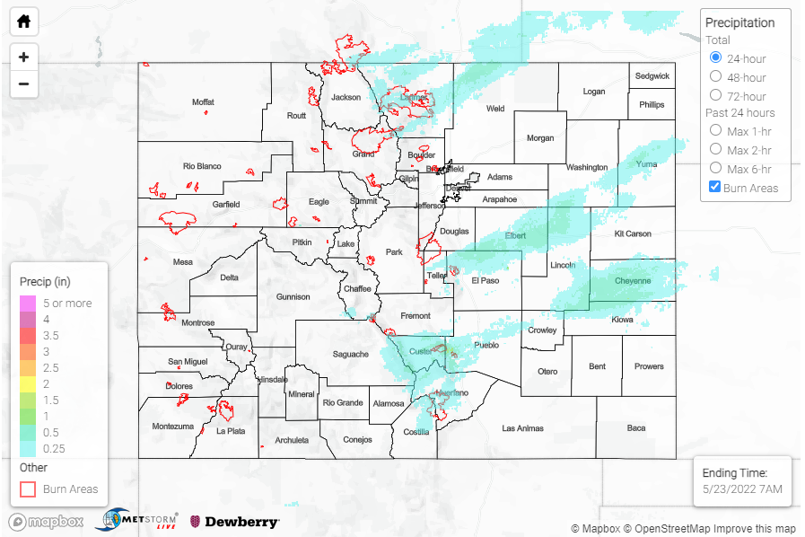
Sunday saw a continued wintry mix of snow and rain for the southern portion of the Urban Corridor and Palmer Ridge. Though it was raining or snowing off and on for much of the day, precipitation totals are modest in this region, hovering from 0.25-0.30 inches for the Monument Area and 0.16-0.29 inches in Limon – all from CoCoRaHS observers. However after a completely snowless April, Colorado Springs is now on track for the 5th snowiest May on record.


By late evening and overnight, precipitation expanded to the Southeast Mountains and Southeast Plains, with snow continuing to fall at higher elevations. A few notable totals from observers include 0.95 inches in Buelah (Pueblo County) and 0.80 inches in La Veta (Huerfano County), from 12 inches of snow depth. There was also overnight rain for Northern Front Range, Urban Corridor, and Northeast Plains last night, both the CoCoRaHS and Fort Collins gauge network have observations between 0.15-0.35 across town and the adjacent foothills.

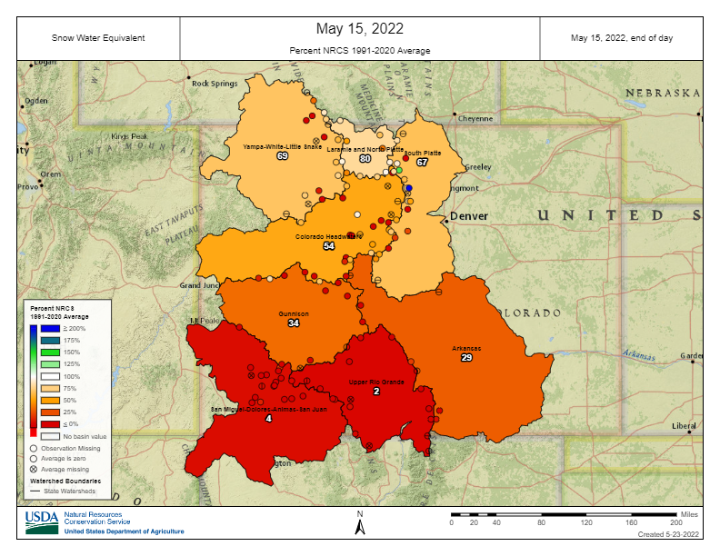
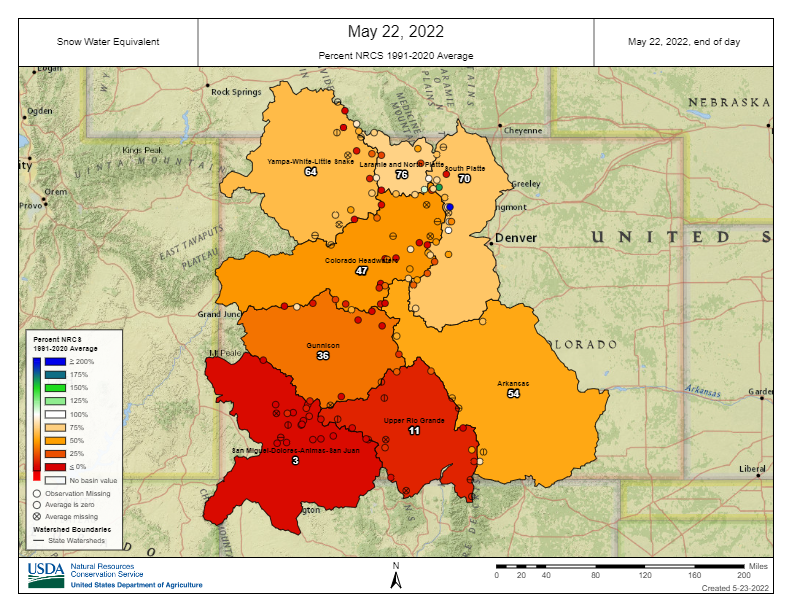
The system that impacted Central-Southern Colorado over the weekend was beneficial in rebounding some mountain snowpack after what was initially going to be a very early melt out, especially for the Arkansas basin. The top and bottom maps show basin-wide snow water equivalent (SWE) % of normal on May 15 and May 22, 2022. So even though May 22 is one week later, there was an increase in the % of normal SWE in the Arkansas basin from 29% on May 15 to 54% on May 22. Obviously 54% of normal is still not ideal, especially with the ongoing drought conditions, but it’s better than nothing. The Upper Rio Grande, South Platte, and Gunnison basins also saw a bit of a boost from this snowstorm as well. Basins in Northern and Western Colorado saw a typical decrease in SWE over the course of a week.

There was no flooding reported yesterday. For precipitation estimates in your area over the last few days, check out the State Precipitation Map below.

Click Here For Map Overview


The map below shows radar-estimated, rainfall gage-adjusted Quantitative Precipitation Estimates (QPE) across Colorado. The map is updated daily during the operational season (May 1 – Sep 30) by 11AM. The following six layers are currently available: 24-hour, 48-hour and 72-hour total precipitation, as well as maximum 1-hour, 2-hour and 6-hour precipitation over the past 24 hour period (to estimate where flash flooding may have occurred). The accumulation ending time is 7AM of the date shown in the bottom right corner. Also shown optionally are vulnerable fire burn areas (post 2012), which are updated throughout the season to include new, vulnerable burn areas. The home button in the top left corner resets the map to the original zoom.