STP 05-10-2015: Impressive Storm Delivers a Full Course of Weather, Plus Some Interesting Facts

Issue Date: Sunday, May 10th, 2015
Issue Time: 9:10 AM MDT

Summary:

The late spring storm that barreled across Colorado on Saturday certainly lived up to, if not exceeded, its expectations. Numerous waves of shower and thunderstorm activity moved in a repetitive fashion across Eastern Colorado. The rain fell over saturated soils, quickly leading to flooded fields and eventually roadways. By early evening, Logan and Morgan counties in the Northeast Plains were hit especially hard, with widespread reports of impassable roadways.

There are several interesting things to note about this event. First is that during the entirety of this event, hourly rainfall rates essentially stayed at or below 1 inch per hour. In fact, most of the hourly rain rates were in the 0.4 to 0.7 inch per hour range. Thus, it was the persistence of the rainfall and saturated soils that are equally responsible for the flooding. This shows that high rainfall intensities are not always required to cause very impactful runoff and flooding concerns in Colorado. Second, despite the fact that not everyone likes snow in May, the snowfall acted to tremendously reduce the rate of runoff and has likely saved many rivers and streams from going into much more severe flooding.

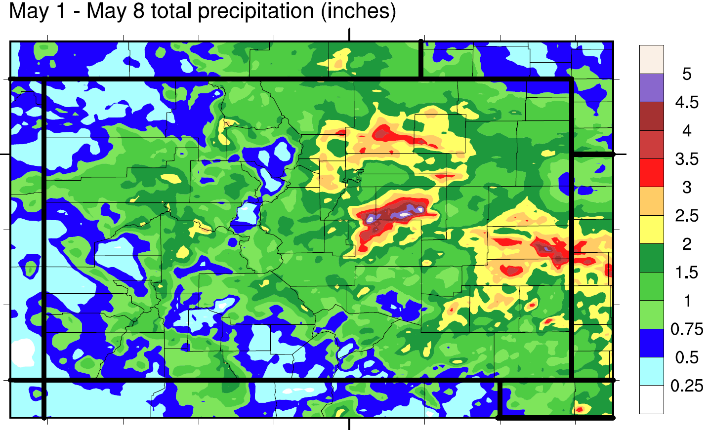
Another interesting fact we found this morning relates to consecutive rainy days in Colorado. Despite the fact that consecutive rainy (or snowy!) days in Colorado are rare, there have now been 10 days in a row where Denver has recorded precipitation. Going back to the records from Buckley Air Force Base (in Denver) that date back to 1961, we found only one instance where more consecutive days with precipitation were recorded: 11 back in July of 2011! This makes the past 10 day period as the second highest on record.

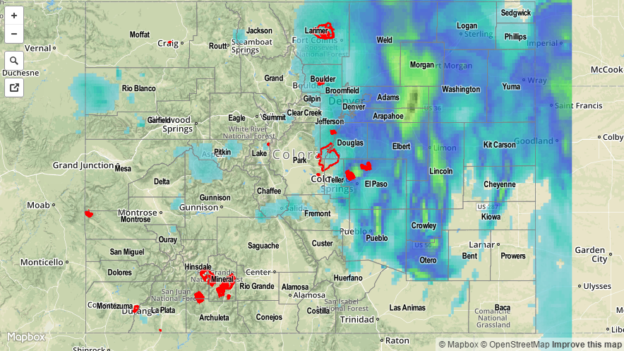
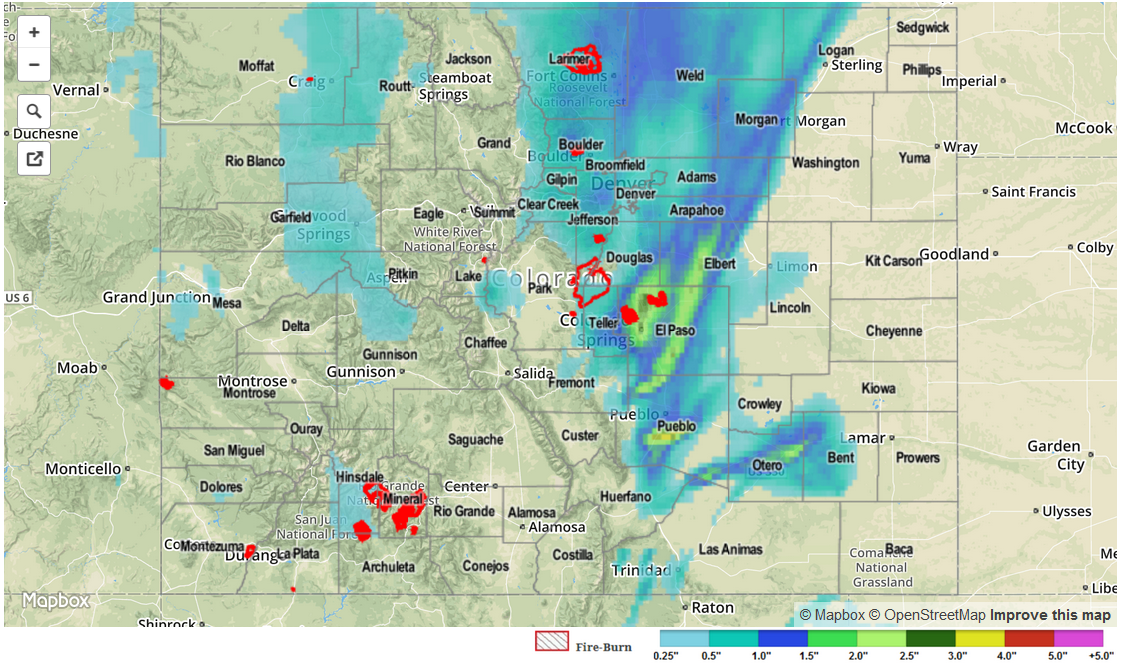
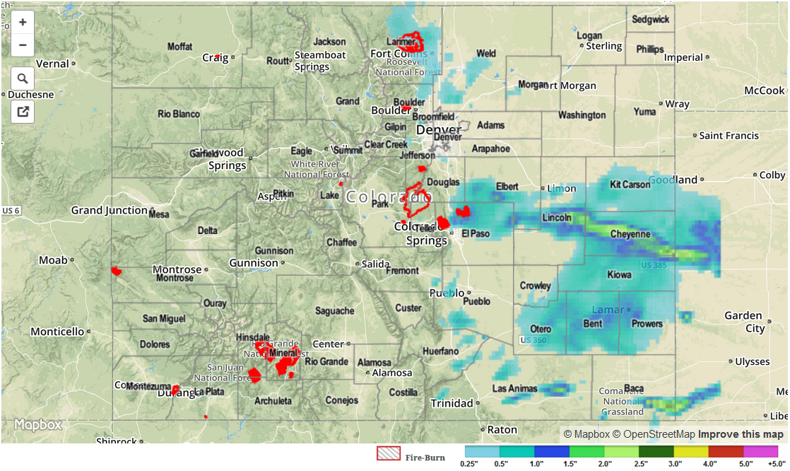
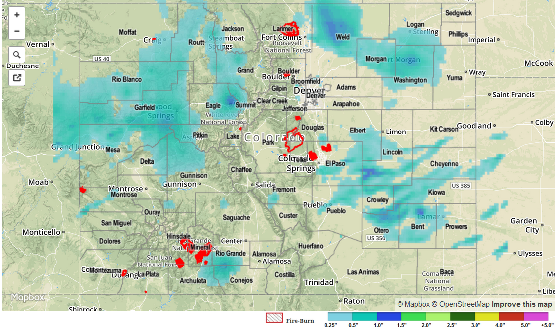
Now back to yesterday’s weather. Total 24-hour rainfall amounts over two inches were observed across many counties in eastern Colorado. Some particular amounts include:

• 3.92 in Morgan county
• 3.00 in Logan county
• 2.53 in Douglas county
• 2.11 in Lincoln county

In addition to the rainfall, numerous severe weather reports were received yesterday afternoon. The National Weather Service issued thirteen tornado warnings and over a dozen actual tornado reports were received. Numerous hail reports, stating sizes from 1 inch to 2.5 inches were received from Pueblo, Cheyenne and Kit Carson. In addition to the flooding in Morgan and Logan counties, there were a handful of scattered flooding reports of washed out roadways and high streamflows. Finally, up to 10 inches of snow was officially recorded along the Palmer Ridge. What a day!

As always, please see the map below for estimated precipitation amounts in your area.

20150510_STPImage
Storm Total Precip Legend

STP 05-09-2015: Rainfall Over Saturated Soils Took Its Toll On Friday

Issue Date: Saturday, May 9th, 2015
Issue Time: 8:55 AM MDT

Summary:

An impressive late spring cyclone marched towards Colorado on Friday bringing plenty of dynamics and moisture to cause widespread showers and thunderstorms across many regions of the state. In addition, numerous locations have experienced as much rainfall over the past week as typically falls in two to three months! The map below shows the estimated total rainfall observed from Friday, May 1 through Friday, May 8, the first full week of the Flood Threat Bulletin. And what a week it has been!.Note that this map goes through 6AM Friday, and thus does not include the additional hefty rainfall observed yesterday. We can see most of the state has seen more than one inch of rain with many locations east of the Continental Divide experiencing 2-3 inches, and up to 5 inches over the Palmer Ridge. Needless to say, soils are now saturated across almost all of eastern Colorado.

FTB_week1_precip

Now back to yesterday’s weather. As expected, morning shower and thunderstorm activity intensified in the late afternoon with multiple rounds of thunderstorms were observed in the late evening and overnight hours. Fortunately, the relatively cool weather limited the amount of moisture the atmosphere can hold, keeping hourly rainfall intensity below 1.5 inches per hour. Nonetheless, the persistence of the rainfall caused numerous flood warnings and advisories. In addition, four confirmed flooding reports were recorded:

• Fire department reported flash flooding in La Junta
• Law enforcement reported 6-8 inches of water covering I-25 near Colorado Springs
• Several debris slides were noted in Boulder county
• Two to four feet of water covered a gold course in Weld county

Observed 24-hour rain totals exceeded 3 inches in El Paso and Morgan counties, while 1 inch or more was noted across a long list of counties in Northeast Colorado. As always, please see the map below for estimated rain totals in your area.

Lastly, a few thunderstorms in the Southeast Plains had enough instability to cause large hail up to 1.75 inches in diameter. Meanwhile, smaller hail in the 0.25 to 0.75 inch range, was observed at a handful of different locations west of the Continental Divide. Note that hail (which appears as a very strong signal in radar reflectivities) may have caused slightly overestimated rainfall amounts in Pueblo, El Paso and Elbert counties.

STP_snapshot_20150509

STP 05-08-2015: Impressive Rainy Start to May, as Showers and Thunderstorms Continued

Issue Date: Friday, May 8th, 2015
Issue Time: 9:05 AM MDT

Summary:

On Thursday, sunshine peaked through the clouds to warm the ground. This combined with a favorable upper-level pattern and a moist atmosphere to cause showers and thunderstorms across many parts of Colorado. While most rainfall rates remained light enough to prevent flooding, a Flash Flood Warning was issued for El Paso County during the early afternoon for particularly heavy rainfall runoff. This was also exacerbated by saturated soils from consecutive days of rainfall. An Areal Flood Advisory was issued for Routt County during the late morning for “rain-on-snow” type streamside flooding of the Yampa River. In addition to heavy rainfall, a whole string of Severe Thunderstorm warnings were issued over the Palmer Ridge, Raton Ridge and Southeast Plain regions for large hail. A dozen or so hail reports were observed across the state ranging from 0.75 inches along the I-25 corridor from Colorado Springs southward to the New Mexico border. Larger hail, up to 1.75 inches in diameter was observed in Cheyenne county. Several funnel reports were received along with a tornado report in eastern Baca county on the Kansas border.

Highest 24-hour rainfall amounts were once again noted in El Paso county with 2.05 inches observed in northeast of Colorado Springs. Numerous additional reports of 1 inch or more were observed in El Paso, Otero, Weld, Adams, Gilpin and Lincoln Counties.

Officially, one flooding report was received when an observer noted Cottonwood Creek coming out of its banks northeast of Colorado Springs.

Please see the map below for estimated rain totals in your area.

STP_snapshot_20150508

STP 05-07-2015: Another Day of Showers and Thunderstorms, a Few Were Severe

Issue Date: Thursday, May 7th, 2015
Issue Time: 9:00 AM MDT

Summary:

Moisture has remained steady for the last few days, and this led to another day of scattered showers and thunderstorms for Colorado. A few severe storms rumbled across the Southeast Plains, though because it is very sparsely populated, no severe reports were relayed to the local NWS office. 24-hour rainfall totals across the state were generally between 0.25 and 0.50 inches, however a few locations received around 1 inch. The highest totals reported by CoCoRaHS observers were the following:

Weld County: 1.49 inches
Larimer County: 0.96 inches
Prowers County: 0.91 inches
Morgan County: 0.89 inches

Storm reports to the local NWS offices across the state showed a mix of rain, hail, and even a funnel cloud. Storm reports of note, include:

Hail: 5 miles SW of Wiley (Bent County): 0.88 inch, 4 miles SW of Pueblo (Pueblo County): 0.75 inch
Funnel cloud: 2 miles NE of Fort Lyon (Bent County)

No flash flooding occurred yesterday.

STP_snapshot_20150507