STP 06-15-2015: Scattered Showers and Thunderstorms, Once Again, Rumbled Across Colorado

Issue Date: Monday, June 15th, 2015
Issue Time: 9:00 AM MDT

Summary:

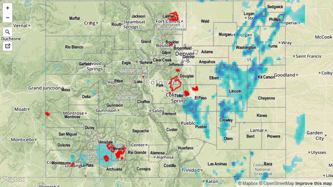
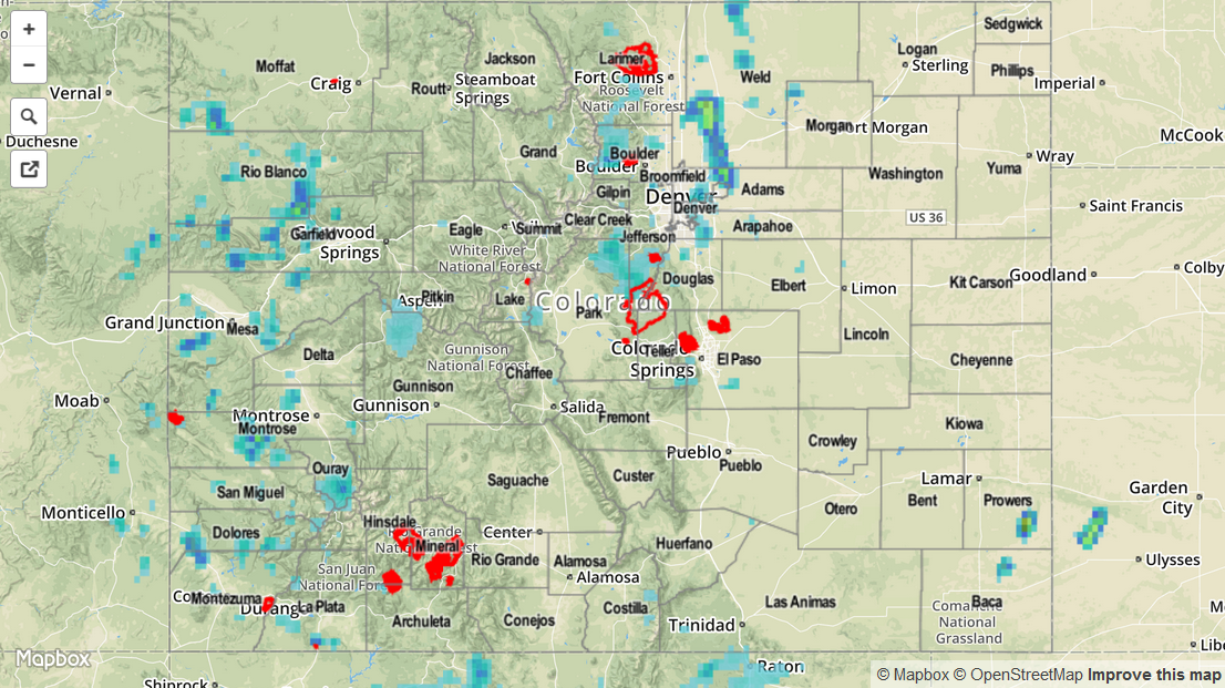
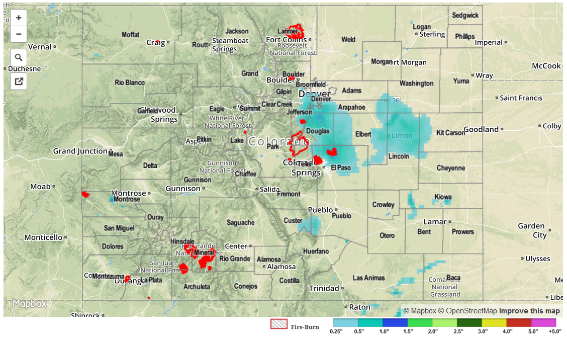
The active June marched on with another day of scattered showers and thunderstorms, with stronger storms producing heavy rain. Although no flash flooding has been reported at this time, flood advisories/warning continue across the state. A few severe storms were mixed in, producing mainly large hail and heavy rainfall. As far as storm reports are concerned, there were only 2 that reached severe criteria:

1.75 inch hail: 3 miles S of Sterling (Logan County)
1.0 inch hail: Holyoke (Phillips County)

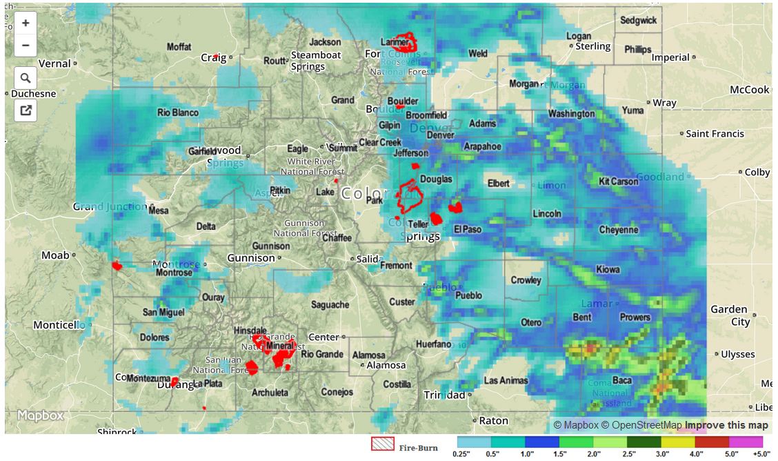
According to National Weather Service storm reports, there were a few heavy rain reports from southern Colorado, and a quick check of IPW observations shows why: Precipitable water values topped an inch in Pueblo and just below an inch in Colorado Springs, leading to very efficient rainfall production. For a statewide look at rainfall totals, be sure and check the radar-derived Storm Total Precipitation map below.

06152015_STPImage
Storm Total Precip Legend

STP 06-14-2015: A Few Heavy Rain Producers Amidst The Bunch

Issue Date: Sunday, June 14th, 2015
Issue Time: 9:25 AM MDT

The streak of active weather that Coloradoans have endured since May has easily spilled over into June. In addition to disturbances in the upper-atmosphere that have been routinely passing overhead, favoring thunderstorms, another supporting factor has been the very high soil moisture and vegetation. In most areas, especially east of the Divide, remarks have been made about how green the landscape is, or how fast the grass is growing (my backyard looks like a jungle…I hope there is not a mountain lion family that has set up shop without letting me know). Plants release an incredible amount of water into the atmosphere, and help maintain very high dewpoints that are one critical element to heavy rain-producing thunderstorms.

Dewpoint temperatures once again stayed in the 40s and 50s on Saturday and combined with favorable conditions aloft to yield thunderstorms. Early thunderstorms were mostly a nuisance in nature, with generally light rainfall amounts of well below an inch. However, as storms stayed around and combined with other storms, by mid-afternoon rain began to come down in sheets in a few places. The most intense storm in the state was likely in Weld County where an observer recorded a 24-hour rainfall of 1.74 inches; most of this fell with the aforementioned one storm in an hour or so. This storm caused flash flooding near Milliken where Highway 66 was closed due to flood waters. Meanwhile, the normally dry San Luis Valley finally notched some beneficial water, with Alamosa reporting about 0.6 inches. Thunderstorms also dotted the landscape west of the Divide, though rainfall was less than 0.5 inches for the vast majority of locations.

For estimated rainfall in your area, be sure to check out the rainfall map below.

06142015_STPImage
Storm Total Precip Legend

STP 06-13-2015: Storms Had Hard Time Battling Subsidence

Issue Date: Saturday, June 13th, 2015
Issue Time: 8:55 AM MDT

Friday’s weather began in a threatening fashion, with many residents along the Urban Corridor waking up to moderate rainfall. Over many areas, this was falling on saturated soils from the previous day’s rainfall making runoff especially high. However, once the rainfall subsided in the late morning hours, the atmosphere indicated that it needed a break! Despite high dewpoint temperatures in the 50s, and adequate precipitable water, storms that formed in the Southeast Plains and San Juans just could not muster any strength. A close inspection of yesterday afternoon’s atmosphere revealed a disturbance leaving the state, causing significant sinking air motion in the upper levels. The result: the odds of widespread heavy rainfall were much reduced. Nonetheless, at least one isolated storm took advantage of the juicy atmosphere to deliver very heavy rainfall. This storm reportedly dumped 2 inches of rain in less than 30 minutes near the town of Kim, in Las Animas County. Fortunately, this kind of action was few and far between, and no official flood reports were observed.

Many high and low elevation rivers were swollen from Thursday’s rainfall, but Friday’s drying gave them an opportunity to recede a bit. Only small stretches of the South Platte, Arkansas remain in Minor flood stage. The lowering of stream levels is expected to continue as the snowpack is now almost completely gone.

For estimated rainfall in your area, be sure to check out the rainfall map below.

STP_snapshot_20150613

STP 06-12-2015: Thursday: About As Active As It Gets

Issue Date: Friday, June 12th, 2015
Issue Time: 9:10 AM MDT

Summary:

On Thursday, very moist conditions statewide promoted an incredibly active hydrometeorological day basically across the entire state. Morning showers and storms were ongoing across the Northwest Slope and Grand Valley. These storms increased in intensity and coverage as the day wore on. By early evening, almost everyone west of the Divide saw at least some rainfall. Most storms produced light to moderate rainfall amounts, in the 0.3 to 0.7 inch per hour range. However, several stronger storms produced rain rates over 1 inch per hour. The maximum observed 24-hour rain totals were as high as 1.5 inches. But chances are that there were likely higher amounts in some remote, non-measured locations. Numerous flood warnings and advisories were in place mainly over the San Juan mountains. A flooding report was received in Gunnison County, where an emergency manager noted a washed out road near Kebler Pass.

Meanwhile, areas east of the Divide had their own set of weather to experience. Thunderstorm activity began shortly after noon with initially light to moderate rainfall amounts. But as storms grew in scale and coverage, this rapidly changed with many heavy rain producing storms scattered all the way from the Wyoming border south and east through the Arkansas River valley. Highest 30-minute rainfall totals were in the 1.8 inch range (Larimer county) while highest 1-hour rainfall was around 2.2-2.4 inches. A few notable 24-hour rainfall amounts were:

  • 3.92 inches in Elbert County
  • 3.84 inches in Douglas County
  • 3.47 inches in Denver County
  • 3.34 inches at a USGS gauge in Las Animas County

As dry air was initially present over the Southeast Plains, early storms there were supercellular in nature. The result was some very large hail (up to 3 inches in far southeast Colorado!), and even a few tornado sightings in Baca County.

For estimated rainfall in your area, be sure to check out the rainfall map below.

STP_snapshot_20150612