SPM 06-15-2022: Seasonal Temps Statewide, Showers and Storms for Northeast Plains

Issue Date: Wednesday, June 15th, 2022
Issue Time: 10:30 AM MDT

Summary:

Cooler temperatures near seasonal norms were widespread across Colorado yesterday, making for a comfortable Tuesday after the record-breaking heat of late. Most of the state saw a fair amount of sunshine, as well.

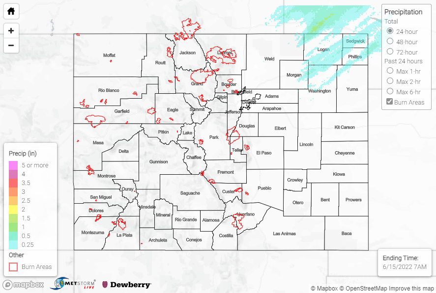
Later in the day, a weak shortwave trough passing overhead led to a strengthening low-level jet atop a frontal boundary draped across the Southeast Plains. The nose (or terminus) of this jet was able to extend its way into the Northeast Plains, where some elevated instability led to showers and storms developing by late afternoon/evening.

Precipitation was mainly confined to the far Northeast Plains, where amounts 0.25-0.50” were observed under the more intense showers and storms. The highest rain gauge observation was 0.35” near Holyoke, although rain gauge coverage in this part of the state is sparse. QPE data suggests amounts closer to and exceeding 1.00” may have been observed at a few locations. No severe weather was reported.

Red Flag Warnings continued Tuesday for much of south and southwest Colorado, with low relative humidities and deep mixing producing gusty winds. Several non-thunderstorm wind gusts of 45-50 mph were reported west of I-25.

The Boulder WFO allowed the Flood Advisory for the upper reaches of the Colorado River and Tonahutu Creek in Grand County to expire early this morning, as water levels continue returning to normal. The high waters of the past several days prompted Rocky Mountain National Park to temporarily close at least one trail and several access roads on the Park’s west side, per Colorado Public Radio. Before reopening, the affected roads and trails will be evaluated for damage from the snowmelt flooding. Flows on several other creeks, streams, and rivers in the Northern Mountains, Central Mountains, and Front Range are also returning to normal.

There was no flooding reported yesterday. For precipitation estimates in your area, check out the map below.
Click Here For Map Overview

The map below shows radar-estimated, rainfall gage-adjusted Quantitative Precipitation Estimates (QPE) across Colorado. The map is updated daily during the operational season (May 1 – Sep 30) by 11AM. The following six layers are currently available: 24-hour, 48-hour and 72-hour total precipitation, as well as maximum 1-hour, 2-hour and 6-hour precipitation over the past 24 hour period (to estimate where flash flooding may have occurred). The accumulation ending time is 7AM of the date shown in the bottom right corner. Also shown optionally are vulnerable fire burn areas (post 2012), which are updated throughout the season to include new, vulnerable burn areas. The home button in the top left corner resets the map to the original zoom.

SPM 06-14-2022: Rain for Northwest Slope, Northern Mountains, and Front Range

Issue Date: Tuesday, June 14th, 2022
Issue Time: 11:00 AM MDT

Summary:

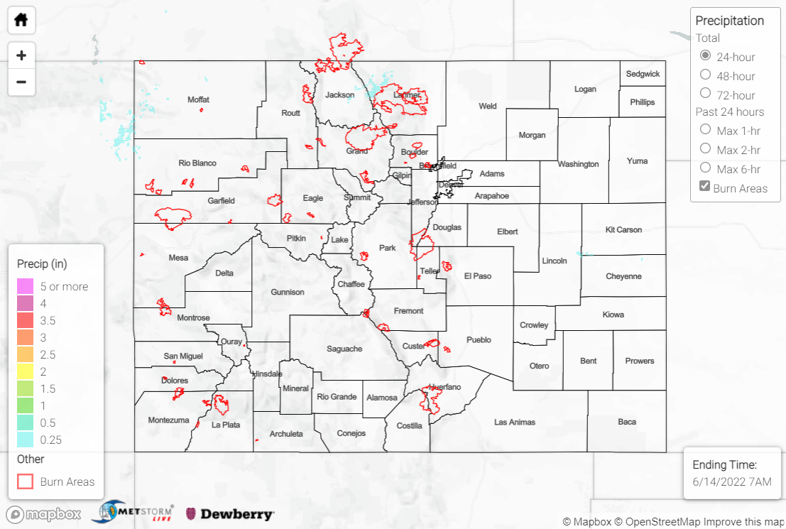
Yesterday featured another day of heat before a slight respite today following a frontal passage across the state last night. An approaching upper-level trough over the Great Basin/Northern Rockies and the surface cold front preceding it helped to produce showers and storms by early Monday evening across the Northwest Slope, Northern Mountains, and northern Front Range.

Precipitation amounts with these showers and storms were light, with T-0.15” generally observed. The heaviest precipitation fell across northwestern Moffat County and northwestern Larimer County, where amounts closer to and slightly exceeding 0.25” were observed. To the east of the mountains across the Plains, dry westerly downslope flow prevented precipitation from falling.

Fort Collins, Colorado Springs, Pueblo, and Burlington all broke record high temperatures yesterday, while Denver and Greeley tied record highs. Deep mixing across the state tapping into strong southwesterly flow aloft, along with a tightening surface pressure gradient, led to another day of windy conditions; gusts of 35-50 mph were widespread, with some areas seeing gusts of 60-70+ mph, including 74 mph near Douglas Pass. Red Flag Warnings, High Wind Warnings, and Wind Advisories were once again widespread.

Smoke from wildfires in Arizona, along with dust from New Mexico, was transported northeastward across much of southeastern Colorado yesterday, with notable reductions in air quality and visibility. Thankfully, most of this dust and smoke was cleared out with the passage of the cold front.

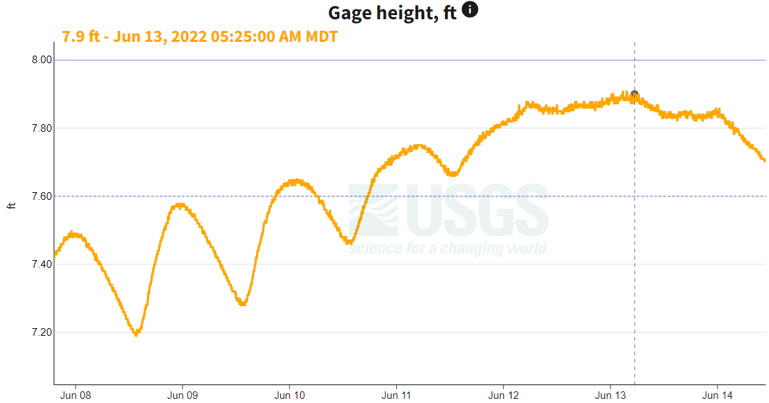
The Flood Advisory for the upper reaches of the Colorado River and Tonahutu Creek in Grand County remains in effect until 6:30 AM MDT tomorrow. The river appears to have peaked at 7.9 feet early Monday morning (flood stage is 8.0 feet), with flows decreasing since, per the USGS (see the gage height graph below near Grand Lake). Several other creeks, streams, and rivers in the Northern Mountains, Central Mountains, and Front Range continue observing above normal flows due to snowmelt.

There was no flooding reported yesterday. For precipitation estimates in your area, check out the map below.
Click Here For Map Overview

The map below shows radar-estimated, rainfall gage-adjusted Quantitative Precipitation Estimates (QPE) across Colorado. The map is updated daily during the operational season (May 1 – Sep 30) by 11AM. The following six layers are currently available: 24-hour, 48-hour and 72-hour total precipitation, as well as maximum 1-hour, 2-hour and 6-hour precipitation over the past 24 hour period (to estimate where flash flooding may have occurred). The accumulation ending time is 7AM of the date shown in the bottom right corner. Also shown optionally are vulnerable fire burn areas (post 2012), which are updated throughout the season to include new, vulnerable burn areas. The home button in the top left corner resets the map to the original zoom.

SPM 06-13-2022: Heat Statewide, Showers and Storms East of I-25

Issue Date: Monday, June 13th, 2022
Issue Time: 10:45 AM MDT

Summary:

Sunday was another hot day across Colorado thanks to the southern U.S. ridge that continues to dominate weather in the region. Thermometers tagged triple digits in many locations, with Grand Junction reaching 101 degrees and breaking the old record that had stood for 104 years!

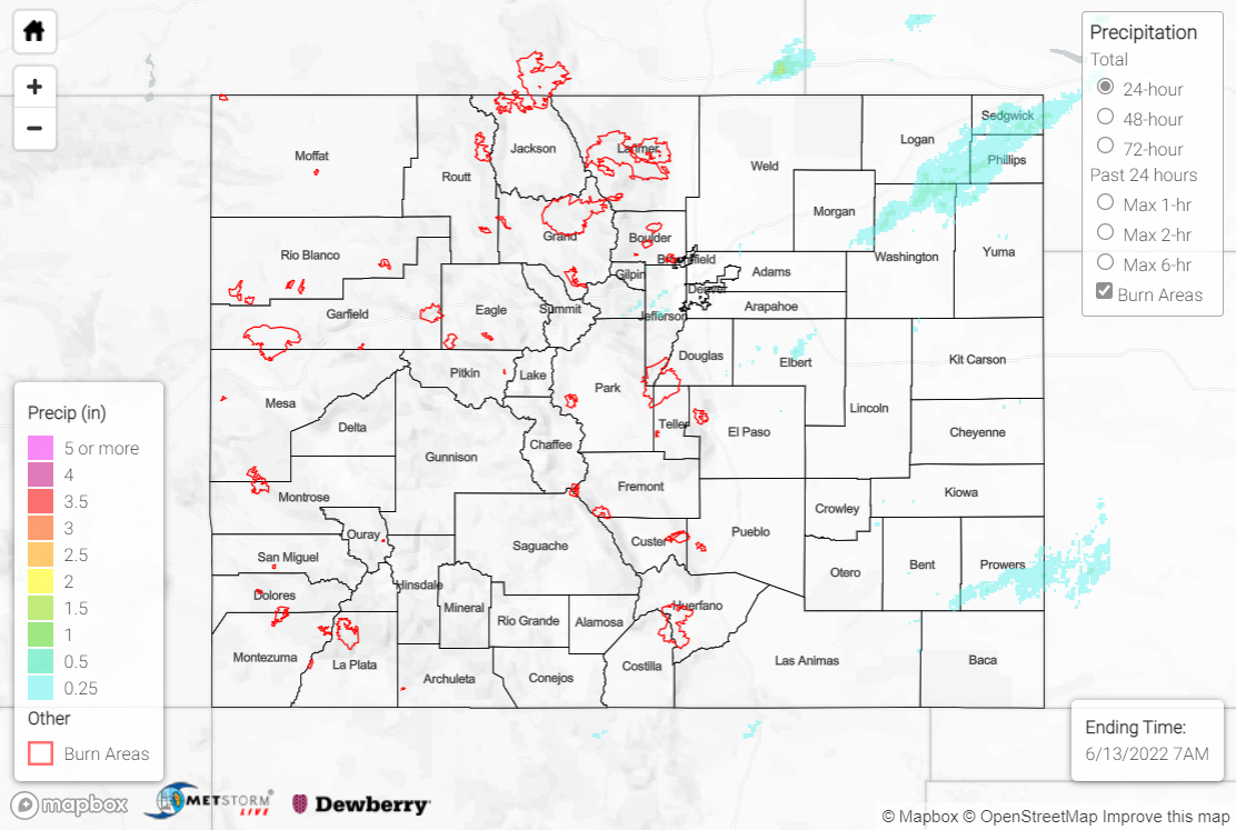
With diurnal heating and a weak disturbance passing overhead, high-based showers and storms once again broke out in the afternoon along the I-25 corridor before tracking eastward into the Plains. The atmosphere was not overly conducive to severe weather compared to previous days, but a few storms became marginally severe and prompted numerous Severe Thunderstorm Warnings. Downbursts with gusts of 50-60 mph were reported, along with 1” hail near Burdett. One cell even spawned a brief landspout tornado just north of Denver International Airport:


Precipitation was mainly confined to the Urban Corridor, Palmer Ridge, and Northeast/Southeast Plains, with amounts of 0.25-0.50” observed under most of the showers and storms. The exceptions were along the I-76 corridor northeast of Fort Morgan, and Bent and Prowers Counties, where localized amounts of 1.00-1.50+” were observed; storms in these locations were able to tap into better moisture from the east and produce heavier rainfall.

For the western half of the state, Sunday was dry, windy, and hot, with Heat Advisories, Wind Advisories, and Red Flag Warnings blanketing the map. A new wildfire, the Lopez Fire, was sparked 10 miles north of Del Norte, with an estimated 88 acres burned so far; U.S. Forest Service personnel are on scene.

Water levels remain high along the upper reaches of the Colorado River in Grand County, and the Tonahutu Creek is also now producing minor lowland/meadow flooding. As such, the Boulder WFO extended the Flood Advisory for snowmelt flooding through 6:30 AM MDT Wednesday. Several other creeks, streams, and rivers in the Northern Mountains, Central Mountains, and Front Range continue observing above normal flows due to snowmelt.

There was no flooding reported yesterday. For precipitation estimates in your area, check out the map below.
Click Here For Map Overview

The map below shows radar-estimated, rainfall gage-adjusted Quantitative Precipitation Estimates (QPE) across Colorado. The map is updated daily during the operational season (May 1 – Sep 30) by 11AM. The following six layers are currently available: 24-hour, 48-hour and 72-hour total precipitation, as well as maximum 1-hour, 2-hour and 6-hour precipitation over the past 24 hour period (to estimate where flash flooding may have occurred). The accumulation ending time is 7AM of the date shown in the bottom right corner. Also shown optionally are vulnerable fire burn areas (post 2012), which are updated throughout the season to include new, vulnerable burn areas. The home button in the top left corner resets the map to the original zoom.

SPM 06-12-2022: Heat Continues, Showers and Storms Late in Day

Issue Date: Sunday, June 12th, 2022
Issue Time: 11:45 AM MDT

Summary:

Saturday saw dry conditions for most of the state as the heat continued to build across the region. Denver tied its record high of 100 degrees set back in 2013 and also tied its record for earliest calendar day to reach 100 degrees. Grand Junction reached 102 degrees, breaking its old record of 101 set back in 1918!

A few high-based showers and storms were able to develop by late afternoon in the high terrain thanks to a weak disturbance passing overhead; little to no precipitation (T-0.05”) reached the ground with this activity given the dry sub-cloud layer, but a few cells produced gusty outflow winds as they moved out into the eastern Plains. Late in the evening one cluster of storms along the far eastern I-70 corridor was able to intensify, overcome the dry low levels, and produce meaningful precipitation across Cheyenne and Kit Carson Counties with amounts of 0.50-1.00” falling. This same cluster prompted the issuance of a Severe Thunderstorm Warning, but no severe weather was reported statewide.

A unique atmospheric phenomenon was observed last night in the far eastern Plains and into northwest Kansas, as heat bursts occurred after midnight with the dissipating showers and storms. Heat bursts are relatively rare and usually occur after dark under certain atmospheric conditions when the outflow of dissipating storms loses its moisture to evaporation, and then warms due to compression as it descends to the surface. Heat bursts usually bring gusty winds, rapid increases in surface temperature, and rapid decreases in relative humidity. Check out this example from just across the border in Bird City, KS:

The Flood Advisory for snowmelt along the upper reaches of the Colorado River in Grand County remains in effect until 6:45 AM MDT tomorrow; numerous other creeks, streams, and rivers in the high country continue observing above normal flows due to snowmelt.

There was no flooding reported yesterday. For precipitation estimates in your area, check out the map below.
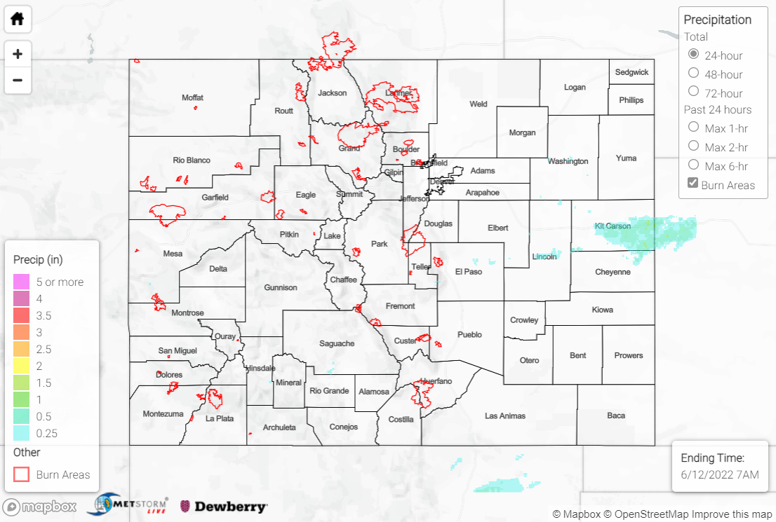
Click Here For Map Overview

The map below shows radar-estimated, rainfall gage-adjusted Quantitative Precipitation Estimates (QPE) across Colorado. The map is updated daily during the operational season (May 1 – Sep 30) by 11AM. The following six layers are currently available: 24-hour, 48-hour and 72-hour total precipitation, as well as maximum 1-hour, 2-hour and 6-hour precipitation over the past 24 hour period (to estimate where flash flooding may have occurred). The accumulation ending time is 7AM of the date shown in the bottom right corner. Also shown optionally are vulnerable fire burn areas (post 2012), which are updated throughout the season to include new, vulnerable burn areas. The home button in the top left corner resets the map to the original zoom.