STP 06-26-2016: Bulk of Precipitation Occurred Over Southeast Colorado

Issue Date: Sunday, June 26th, 2016
Issue Time: 9:00 AM MDT

Summary:

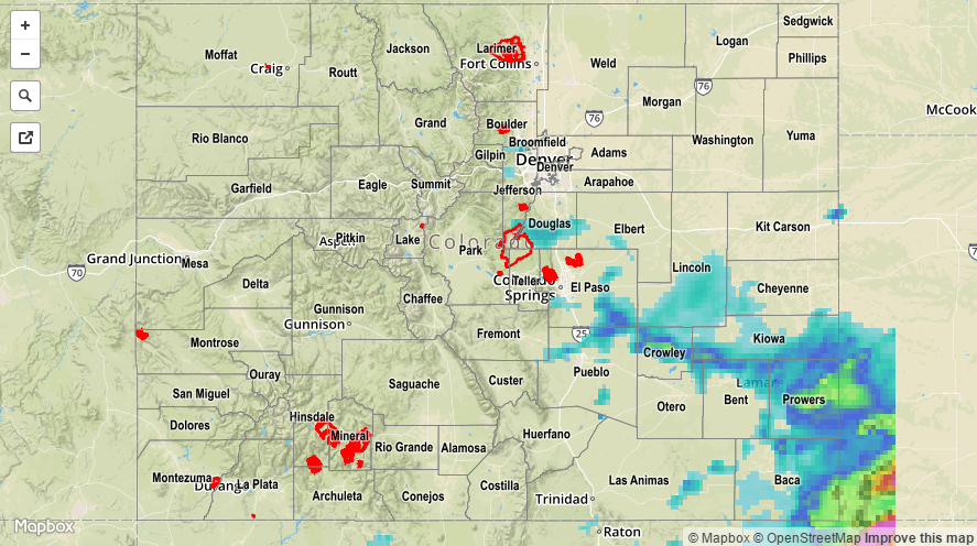
Dry air aloft worked in from the west/northwest yesterday while a cool front drifted southward across the state. These two features, if you will, set up the southeastern quadrant of Colorado to receive the bulk of rainfall yesterday. A few isolated showers/weak thunderstorms dotted areas of the northern Front Range/Urban Corridor, Northern Mountains, Central Mountains, San Juan Mountains, and Southwest Slope, but those resulted in more gusty winds and virga than rainfall.

Scattered-to-widespread showers and thunderstorms worked across the southern Front Range, Urban Corridor, Palmer Ridge, Southeast Plains, Southeast Mountains, and Raton Ridge. A few strong thunderstorms were able to develop, fueled by good instability. Storm reports from yesterday include:

0.75 inch hail: 3 miles ESE of Perry Park (Douglas County) and 3 miles N of Larkspur (Douglas County)
60 mph Thunderstorm Wind Gust: 4 miles S of Cheraw (Otero County)
Thunderstorm Wind Damage: 3 miles N of Ordway (Crowley County), 5 miles NE of Blende (Pueblo County)

No flash flooding was reported yesterday. Please see the STP map below for a look at 24-hour precipitation totals.

20160626_STPImage
Storm Total Precip Legend

STP 06-25-2016: Another Round of Showers/Thunderstorms over the Mountains and East

Issue Date: Saturday, June 25th, 2016
Issue Time: 9:00 AM MDT

Summary:

A battle between dry and moist air was waged across the region yesterday, with dry air only winning out over extreme western/northwestern Colorado. In those locations, dry and hot conditions prevailed during the afternoon, highlighted by fire weather concerns and Red Flag conditions. A few isolated showers/weak thunderstorms developed during the evening/overnight hours as a cool front pushed through the area.

Further to the east, the moist plume fueled another day of scattered showers and thunderstorms. A few were strong, producing small hail, lightning, gusty winds, and periods of heavy rainfall. The majority of the heaviest rain fell over the Northeast Plains and Southeast Plains where low-level moisture was best. Only one severe storm report was filed yesterday, for 1.50 inch hail 3 miles NW of Snyder (Morgan County). The combination of hail/wind also caused tree damage.

No flash flooding was reported yesterday. Please see the STP map below for a look at 24-hour precipitation totals.

20160625_STPImage
Storm Total Precip Legend

STP 06-24-2016: Uptick in Thunderstorms as the Ridge Weakened, Some were Severe

Issue Date: Friday, May 1st, 2015
Issue Time: 9:00 AM MDT

Summary:

Yesterday was quite an active day with widespread showers/thunderstorms across much of Colorado, thanks to a disturbance that shifted across the region. Across the western slope, much of the activity was in shower form, aside from a few stronger thunderstorms that developed during peak heating. To the east, thunderstorms were the main result as better moisture fueled convective activity. A few storms became strong-to-severe. Here are the severe storm reports:

60 mph wind gust: 3 miles N of Crook (Logan County), Crook (Logan County), 1 mile N of Strasburg (Adams County)
80 mph wind gust: 8 miles N of Fort Collins (Larimer County)
Tornado: 5 miles E of Canon City (Fremont County)
1 inch hail: 16 miles NW of Merino (Logan County)
1.5 inch hail: 3 miles NNW of Pawnee Pass (Logan County)

No flash flooding was reported yesterday. For a statewide look at 24-hour precipitation totals, please take a look at the Storm Total Precipitation map below.

20160624_STPImage
Storm Total Precip Legend

STP 06-23-2016: Good Rainfall Coverage, No Flooding Problems

Issue Date: Thursday, June 23nd, 2016
Issue Time: 9:00 AM MDT

Wednesday saw temperatures that were up to 25F cooler than Tuesday. Along with the cool down, some mid-level moisture helped support scattered to widespread shower and thunderstorm activity. In general, many locations picked up from 0.25 to 0.50 inches, with higher values being skewed towards higher elevations. The highest rain intensities across the state were about 0.8 inches per hour. The highest 24-hour observed amount was just over 1 inch in Fremont County. However, rural parts of southeast Colorado saw up to 1.5 inches of rainfall. In addition to the rain, scattered reports of small hail and gusty winds were also noted.

Meanwhile, the Beaver Creek fire of northern Jackson County almost doubled in size on Wednesday, and covered about 7,000 acres of forest land. Containment efforts are ongoing, though gusty winds were an obstacle.

No flooding reports were received yesterday. For specific rainfall estimates in your area, check out our Storm Total Precipitation map below.

20160623_STPImage
Storm Total Precip Legend