STP 07-16-2016: Scattered But Impactful Storms East Of The Continental Divide

Issue Date: Saturday, July 16, 2016
Issue Time: 9:30AM MDT

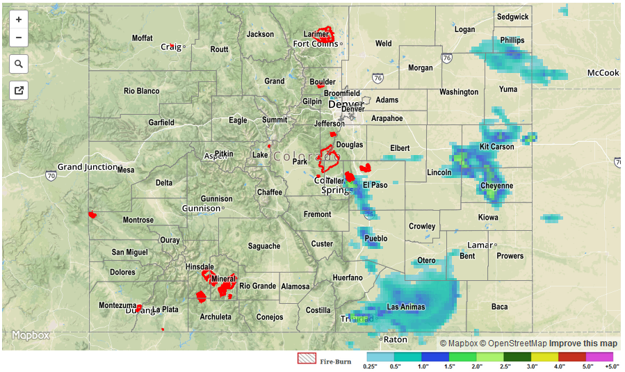
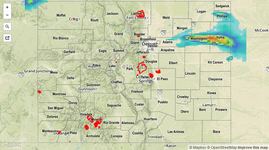
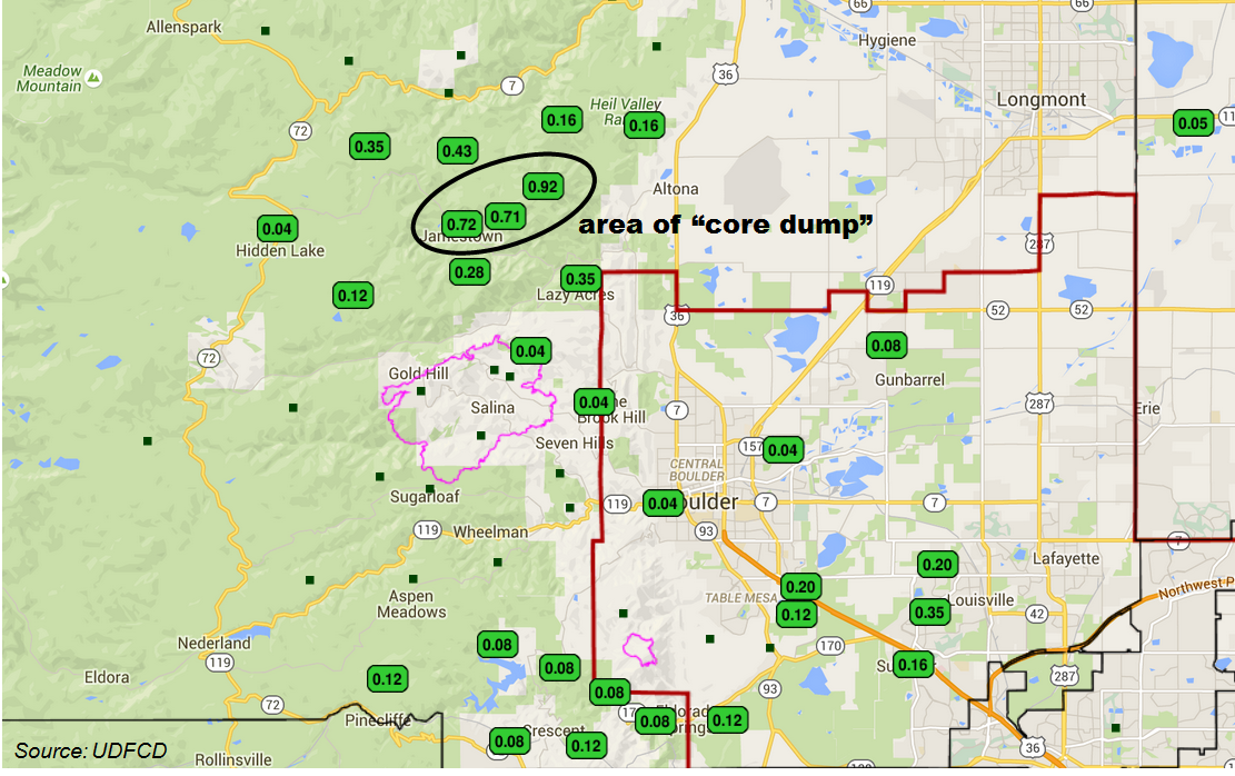
The dog days of summer (a reference to the annual emergence of the Canis Major constellation) are upon us, and that means hot conditions that are capable of producing thunderstorms even with otherwise marginal atmospheric forcing. We saw an example of this on Friday as two pockets of scattered thunderstorms developed in the late afternoon. The first area was in the Front Range and Urban Corridor, where Mother Nature seized a narrow window of opportunity right before the passage of a stabilizing cool front to produce a small cluster of storms that moved across the Denver metro area. One particularly strong cell produced a 30-minute rain rate near 0.75 inches during its “core dump” phase just northeast of Jamestown. This occurs when the storm’s feed of unstable air is rapidly cut-off leading to a quick vertical drop of all the suspended water mass that has recently entered the updraft. We can see this in the 24-hour rainfall map below taken from the Urban Drainage and Flood Control District’s gage totals. Note that several gages show values much higher than surrounding sites, indicating where the storm abruptly collapsed. In addition to the heavy rainfall, 2 inch hail was observed near Centennial.

coredump

The second area was in the Southeast Plains right along the KS border, south of I-70, where very impressive storms raced southward with initial nudging from a southward moving cool front. These storms produced the full gamut of severe weather: hail up to 2.75 inches, straight-line winds over 60 mph, several tornadoes and of special relevance to us, heavy rainfall. Despite the impressive southward storm motions of 45 mph, one hour rainfall rates between 1.5 – 2.0 inches occurred in far eastern Cheyenne and Kiowa counties.

Across the western part of the state, dry and hot conditions continued to support an elevated wildfire risk. There are now four active wildfires classified under the “large incident” category. Please keep informed through local NWS updates as well as the USDA’s Forest Service wildfire page.

There were no official flooding reports yesterday. For specific rainfall estimates in your area, check out our Storm Total Precipitation map below.

STP_20160716

STP 07-15-2016: Uptick in Thunderstorm Activity/Intensity over Eastern Colorado

Issue Date: Friday, July 15th, 2016
Issue Time: 9:00 AM MDT

Summary:

Mother Nature put on a show yesterday from the Front Range/Southeast Mountains and eastward. Strong-to-severe thunderstorms rumbled and produced large hail, strong winds, and periods of heavy rainfall. The Urban Corridor, Palmer Ridge, Southeast Plains, and Raton Ridge experienced the most coverage of storms, with lesser coverage for the Front Range, Southeast Mountains, and Northeast Plains. To the west, mostly sunny and dry conditions were the weather story.

Last night’s severe storms produced plenty of hail. Below are the reports meeting severe criteria (> 1.0 inches in diameter):

2.5 inch hail: Flagler (Kit Carson), 16 miles N of Bethune (Kit Carson)
2.0 inch: 2 miles S of Peterson AFB (El Paso), Peterson AFB (El Paso), 12 miles N of Kit Carson (Kit Carson),
1.75 inch: 3 miles NE of Model (Las Animas), 4 miles SSE of Pueblo Reservoir (Pueblo), 1 mile S of Pinion (Pueblo), 10 miles SSW of Blende (Pueblo), 8 miles SE of Elbert (Elbert), 2 miles S of Elbert (Elbert), 2 miles W of Flagler (Kit Carson), 3 miles S of Seibert (Kit Carson), Vona (Kit Carson), 6 miles N of Stratton (Kit Carson)
1.0 inch: Seibert (Kit Carson)

Street/field flooding likely occurred underneath strong/severe storms. For a closer look at rainfall totals in your area, please see the STP map below for a look at 24-hour precipitation totals.

STP_20160716

STP 07-14-2016: Mainly Dry Afternoon, Thunderstorms Evening and Overnight

Issue Date: Thursday, July 14th, 2016
Issue Time: 9:00 AM MDT

Summary:

Another day, another moisture surge for eastern Colorado led to the development of isolated-to-scattered showers and thunderstorms. The moisture surge was a bit later than previous days’, with the magnitude being similar to that of Monday afternoon/evening. A subtle shortwave moving overhead allowed for scattered coverage, with the bulk of activity south of I-76, east of I-25, and north of Highway 50. Thunderstorms are ongoing this morning across northeast Colorado. According to CoCoRaHS observers (reports as of 7 AM MDT), these counties were the big rainfall winners:

Kit Carson County: 0.28 inches
Yuma County: 0.27 inches
El Paso County: 0.14 inches

No flash flooding was reported. For a more complete look at 24-hour precipitation totals, please take a look at the Storm Total Precipitation map below.

20160714_STPImage
Storm Total Precip Legend

STP 07-13-2016: Line of Thunderstorms Developed over the Northeast Plains

Issue Date: Wednesday, July 13th, 2016
Issue Time: 9:00 AM MDT

Summary:

Overall, the majority of Colorado experienced a mostly sunny and warm day yesterday as dry air continued to be transported in from the west. A moisture surge from the southeast brought low-level moisture back into eastern Colorado, providing the fuel for a line of strong-to-severe thunderstorms across the Northeast Plains. Anchored to a surface boundary and driven by westerly flow aloft, the storms trained over roughly the same locations, leading to good rainfall totals. Yuma County and Washington County were the big rainfall winners. According to CoCoRaHS observers, totals of 1.66 inches, 2.31 inches, and 2.35 inches were reported across Yuma County.

Only one severe storm observation was reported to the NWS: 1 inch hail fell in Abarr (Yuma County). No flash flooding was reported. For a statewide look at 24-hour precipitation totals, please take a look at the Storm Total Precipitation map below, keeping in mind that hail likely contaminated the radar estimates, and actual totals are likely a bit lower.

20160713_STPImage
Storm Total Precip Legend