STP 08-25-2016: Widespread Showers, But Fewer Storms

Issue Date: Thursday, August 25th, 2016
Issue Time: 9:00AM MDT

Summary

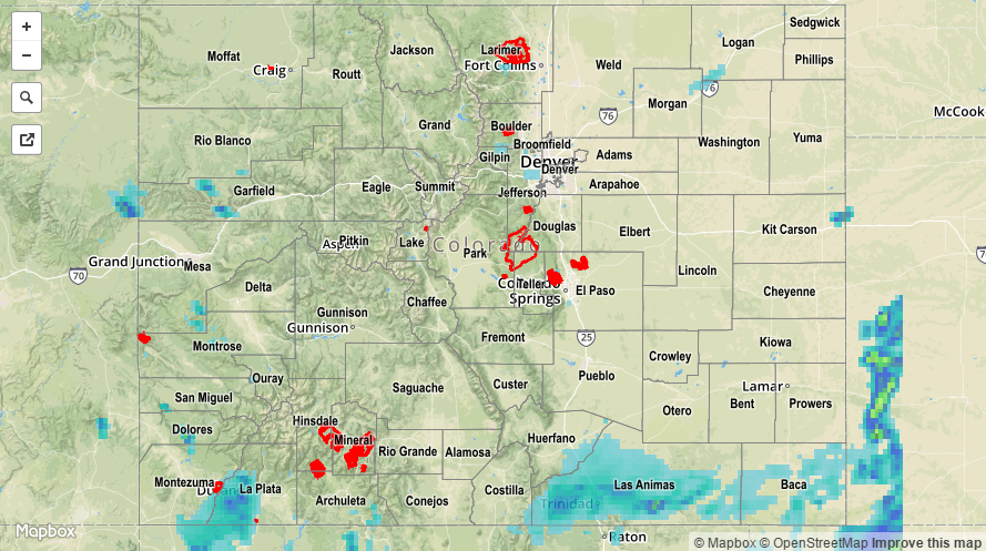
Widespread rainfall made it across the Continental Divide to affect almost all of eastern Colorado, courtesy of a compact but strong shortwave moving across the state. Many Coloradoans along the entire I-25 corridor woke up to find light to moderate rain showers. Rain rates up to 0.25 inches per hour were common, providing beneficial rainfall without causing a runoff threat.

Farther south where more sunshine and warmer temperatures were present, some thunderstorms were found though coverage was reduced compared to the past few days. Highest rainfall rates occurred in three areas. The first was in the southern part of the San Juan Mountains where close to 1 inch of rainfall fell. The second was along the central and southern parts of the Sangre de Cristos where 1 inch fell at a SNOTEL site on the CO/NM border. The third was in the far southeast part of the state where a warm front provided a source of convergence and warm moist air, resulting in instability. Just over 2 inches of rainfall was observed at a CoCoRaHS station in Baca County with even higher amounts possible as indicated by radar. A flood advisory was posted for the region, but fortunately no flooding reports were received as of this morning. Finally, we should note that the Hayden Pass burn area only received 0.1 to 0.3 inches of rainfall yesterday, which was fortunately not enough to cause any runoff.

For rainfall estimates specific to your area, check out our Storm Total Precipitation map below.

20160825_STPImage
Storm Total Precip Legend

STP 08-24-2016: Thunderstorms And Showers Continued Over Southwest, Spilled Over the Divide

Issue Date: Wednesday, August 24th, 2016
Issue Time: 9:00AM MDT

Summary

Rainfall activity further expanded in coverage on Tuesday as a strong cut-off disturbance approach the Four Corners from the southwest. Shower and storm activity started before noon over the San Juans, then quickly spread eastward and northward throughout the mid-afternoon. Limited instability helped subdue rainfall rates for many areas. However, where the sun was able to peek out, higher rain rates occurred. The highest rain rates were located in the far southwest part of the state, notably Montezuma and La Plata Counties. There, up to 1 inch per hour fell at some point in the afternoon and evening. One flash flood advisory was issued for this region and several reports of mud flows resulted in the closer of a few roadways that connected to highway 160. Another patch of higher rates were found just north of I-70 in Rio Blanco County where up to 1 inch also fell. Although no official rain totals were found from this area, there were reports of mud flows on county road 5. The other region where flooding was observed was in Fremont County, in association with the Hayden Pass burn scar. Although rainfall rates were not that high by conventional standards, several days of rainfall plus the lack of infiltration on the scar’s surface resulted in quick runoff. Flash flooding was reported on Big Cottonwood Creek that impacted residential areas as well as a bridge.

Elsewhere, persistent westerly upslope flow provided steady light to moderate rainfall for the high-country near I-70. Up to 1 inch of rainfall was reported in Park County. However, dry air from farther north was again a culprit that limited rainfall rates in northeast Colorado. Nonetheless, a cyclonic circulation developed by late afternoon that resulted in upslope flow along the immediate Front Range. Although rain rates were far from impressive, in the 0.1 – 0.25 inch range, they were certainly welcome in a region that has been unlucky to received rainfall over the past 6 – 8 weeks.

For rainfall estimates specific to your area, check out our Storm Total Precipitation map below.

STP_20160824
Storm Total Precip Legend

STP 08-23-2016: Widespread Moderate Rainfall, Mainly Across Southwest

Issue Date: Tuesday, August 23rd, 2016
Issue Time: 9:00AM MDT

Summary

A noticeable change in the weather pattern led to an increase in rainfall coverage and intensity on Monday. A large-scale trough, supported by a broad subtropical jet spanning across Colorado provide the lift necessary to sustain a long round of thunderstorm and shower activity focused on the San Juans, Southwest Slope, Central Mountains, Southeast Mountains and mainly southern parts of the Grand Valley. With limited instability, rainfall rates were generally kept below the 1 inch per hour range. However, a few isolated areas did manage to tally over 1 inch of rainfall. The highest observed value from CoCoRaHS was 0.59 inches, but several SNOTEL sites in the San Juans picked up 0.8 inches, while a lucky SNOTEL site in the Sangre de Cristo Mountains picked up 1.7 inches of rainfall! In all, four areal flood advisories were issued for parts of the region, though no official flooding reports were received as of this morning.

Meanwhile, farther east, thunderstorm formation was inhibited by drier air that was downsloping off the Continental Divide. Rainfall totals were limited to about 0.25 inches.

For rainfall estimates specific to your area, check out our Storm Total Precipitation map below.

STP_20160823
Storm Total Precip Legend

STP 08-22-2016: Showers and Storms in the South Again

Issue Date: Monday, August 22nd, 2016
Issue Time: 9:00AM MDT

Summary

The weather pattern on Sunday resembled that of Saturday, with round of showers and thunderstorms being limited to the climatologically favored far southern tier of the state. Storms popped up early, but were initially of the garden variety type with very short-term heavy rainfall. By later in the afternoon, outflow boundaries were able to create more favorable convergence zones allowing for some larger and stronger thunderstorms to form. In all, rainfall coverage was quite similar to Saturday, with slightly lower amounts. Highest gaged totals were near 0.75 inches in Archuleta County. However, radar estimates suggest up to 1 inch fell over a few different locations in the Southeast Mountains and San Juans. Notably, even the San Luis Valley picked up appreciable rainfall amounts exceeding 0.5 inches. No official flooding reports were received as of this morning.

Elsewhere, afternoon temperatures on Sunday were up to 20F warmer than Saturday, though only putting them slightly above seasonal normal for this time of year.

For rainfall estimates specific to your area, check out our Storm Total Precipitation map below.

STP_20160822
Storm Total Precip Legend