Issue Date: Wednesday, August 24th, 2016
Issue Time: 9:00AM MDT
Summary
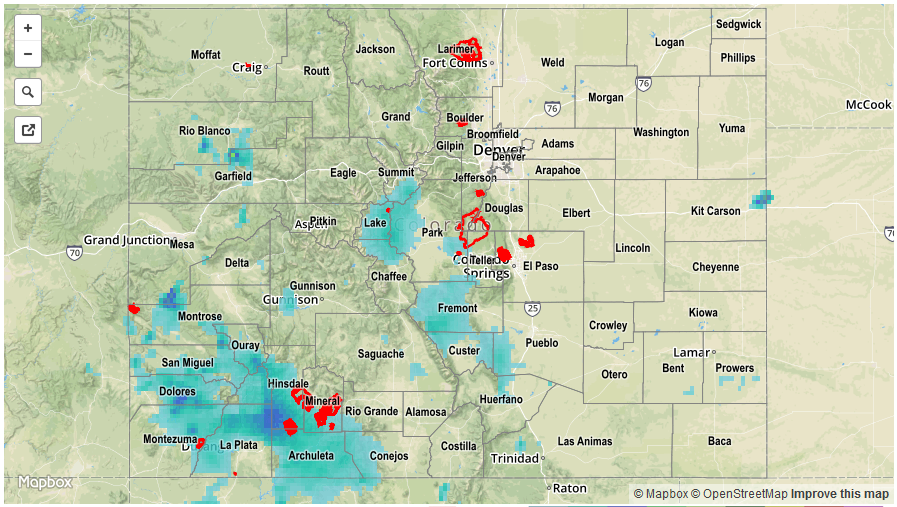
Rainfall activity further expanded in coverage on Tuesday as a strong cut-off disturbance approach the Four Corners from the southwest. Shower and storm activity started before noon over the San Juans, then quickly spread eastward and northward throughout the mid-afternoon. Limited instability helped subdue rainfall rates for many areas. However, where the sun was able to peek out, higher rain rates occurred. The highest rain rates were located in the far southwest part of the state, notably Montezuma and La Plata Counties. There, up to 1 inch per hour fell at some point in the afternoon and evening. One flash flood advisory was issued for this region and several reports of mud flows resulted in the closer of a few roadways that connected to highway 160. Another patch of higher rates were found just north of I-70 in Rio Blanco County where up to 1 inch also fell. Although no official rain totals were found from this area, there were reports of mud flows on county road 5. The other region where flooding was observed was in Fremont County, in association with the Hayden Pass burn scar. Although rainfall rates were not that high by conventional standards, several days of rainfall plus the lack of infiltration on the scar’s surface resulted in quick runoff. Flash flooding was reported on Big Cottonwood Creek that impacted residential areas as well as a bridge.
Elsewhere, persistent westerly upslope flow provided steady light to moderate rainfall for the high-country near I-70. Up to 1 inch of rainfall was reported in Park County. However, dry air from farther north was again a culprit that limited rainfall rates in northeast Colorado. Nonetheless, a cyclonic circulation developed by late afternoon that resulted in upslope flow along the immediate Front Range. Although rain rates were far from impressive, in the 0.1 – 0.25 inch range, they were certainly welcome in a region that has been unlucky to received rainfall over the past 6 – 8 weeks.
For rainfall estimates specific to your area, check out our Storm Total Precipitation map below.